Myersville, Maryland facts for kids
Quick facts for kids
Myersville, Maryland
|
|||
|---|---|---|---|
| Town of Myersville | |||

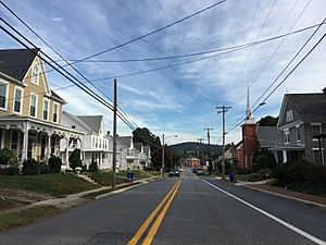
Main Street in Myersville
|
|||
|
|||

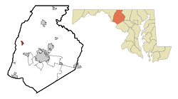
Location of Myersville, Maryland
|
|||
| Country | |||
| State | |||
| County | |||
| Incorporated | 1904 | ||
| Area | |||
| • Total | 1.12 sq mi (2.90 km2) | ||
| • Land | 1.12 sq mi (2.90 km2) | ||
| • Water | 0.00 sq mi (0.00 km2) | ||
| Elevation | 620 ft (190 m) | ||
| Population
(2020)
|
|||
| • Total | 1,748 | ||
| • Density | 1,559.32/sq mi (602.24/km2) | ||
| Time zone | UTC-5 (Eastern (EST)) | ||
| • Summer (DST) | UTC-4 (EDT) | ||
| ZIP code |
21773
|
||
| Area code(s) | 301, 240 | ||
| FIPS code | 24-54875 | ||
| GNIS feature ID | 2391320 | ||
Myersville is a small town in Frederick County, Maryland, United States. It is a community where people live and work. In 2020, about 1,748 people lived there.
Contents
History of Myersville
Myersville became an official town in 1904. At that time, only about 150 people lived there.
In the same year, a special electric train called the Blue Ridge Trolley connected Myersville to the nearby town of Hagerstown. This made travel much easier.
On January 4, 1919, a big fire happened in the center of town. It sadly destroyed many shops and buildings.
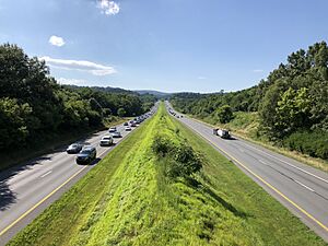
In 1968, a major highway, Interstate 70, was built through Myersville. This helped connect the town to bigger cities.
The town's official borders were made larger for the first time in 1981. This allowed Myersville to grow.
An old farm, the Peter of P. Grossnickel Farm, was added to a special list called the National Register of Historic Places in 1998. This means it is an important historical place.
Catching the D.C. Snipers
In October 2002, two people who were wanted by the police were caught at a rest stop in Myersville. They were found along I-70 when a truck driver recognized their car from police reports.
Geography of Myersville
Myersville covers an area of about 1.02 square miles (2.64 square kilometers). All of this area is land.
A stream called Catoctin Creek starts near Myersville. It flows in a "C" shape around the edges of the town.
Transportation in Myersville
Most people travel to and from Myersville by road. The main highway serving the town is Interstate 70. This highway goes east from Myersville towards Baltimore and west towards Pittsburgh.
You can get to Myersville from I-70 using Maryland Route 17. This other highway runs north and south through the western part of Frederick County. U.S. Route 40 is another highway that passes close to Myersville. It offers another way for people to travel east and west.
Population of Myersville
| Historical population | |||
|---|---|---|---|
| Census | Pop. | %± | |
| 1870 | 139 | — | |
| 1880 | 138 | −0.7% | |
| 1910 | 240 | — | |
| 1920 | 239 | −0.4% | |
| 1930 | 262 | 9.6% | |
| 1940 | 310 | 18.3% | |
| 1950 | 250 | −19.4% | |
| 1960 | 355 | 42.0% | |
| 1970 | 450 | 26.8% | |
| 1980 | 432 | −4.0% | |
| 1990 | 464 | 7.4% | |
| 2000 | 1,382 | 197.8% | |
| 2010 | 1,626 | 17.7% | |
| 2020 | 1,748 | 7.5% | |
| U.S. Decennial Census | |||
2020 Census Information
In 2020, a census (a count of all people) showed that 1,748 people lived in Myersville. There were also 590 homes, and about 71.4% of the people had jobs.
2010 Census Information
The 2010 census counted 1,626 people living in Myersville. There were 531 households (places where people live) in the town.
See also
 In Spanish: Myersville (Maryland) para niños
 | Delilah Pierce |
 | Gordon Parks |
 | Augusta Savage |
 | Charles Ethan Porter |


