Jefferson, Maryland facts for kids
Quick facts for kids
Jefferson, Maryland
|
|
|---|---|

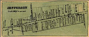
An 1858 Frederick County detail map of Jefferson from Isaac Bond
|
|
| Country | |
| State | |
| County | |
| Area | |
| • Total | 2.79 sq mi (7.22 km2) |
| • Land | 2.79 sq mi (7.22 km2) |
| • Water | 0.00 sq mi (0.00 km2) |
| Elevation | 538 ft (164 m) |
| Population
(2020)
|
|
| • Total | 2,697 |
| • Density | 968.05/sq mi (373.76/km2) |
| Time zone | UTC−5 (Eastern (EST)) |
| • Summer (DST) | UTC−4 (EDT) |
| ZIP code |
21755
|
| Area code(s) | 301, 240 |
| FIPS code | 24-42350 |
| GNIS feature ID | 2583640 |
Jefferson is a small community in Frederick County, Maryland, United States. It is an unincorporated community and a census-designated place (CDP). This means it's an area the government counts for population, but it doesn't have its own city government.
As of the 2020 census, about 2,697 people lived in the Jefferson CDP. The community was first started in 1774. It even became an official town in 1831. However, just one year later, in 1832, the people decided they didn't need a town government. Since then, Jefferson has remained an unincorporated community.
Contents
History of Jefferson, Maryland
Early Beginnings: New Town and New Freedom
Jefferson was first planned in 1774. It was laid out on a 96-acre piece of land owned by Mrs. Eleanor Medley. This original area was called "New Town." It had 40 rectangular lots, with 20 on each side of what is now Maryland Route 180.
Later, in 1795, 22 more lots were added by Elias Delashmutt. These new lots were called "New Freedom." In 1831, both "New Town" and "New Freedom" officially joined together and were named "Jefferson" by the Maryland Legislature.
Growth and Trade in the 19th Century
Jefferson grew a lot in the 1800s. This was mainly because of its important location on the main road between Frederick and Harpers Ferry. Today, this road is Maryland Route 180.
Many wagons and livestock traveled along this road. Because of this, more businesses opened in Jefferson. These businesses served the local farms and also the many travelers passing through. Jefferson became a center for farming trade. During the late 1700s and most of the 1800s, many enslaved people lived and worked there.
Transportation Changes in the 20th Century
In 1907, the Hagerstown and Frederick Railway connected Jefferson to Frederick and Hagerstown. However, Jefferson Pike was still the only way to reach the closest steam-powered train station in Brunswick.
The Name "Trap Town"
Old maps from the late 1700s show Jefferson on what is now MD 180. At the end of the 18th century, it was sometimes called "Trap Town." Local stories say this name came from the many taverns (like inns or pubs) that were in town. There were supposedly taverns at both ends of town. So, a traveler might get "trapped" on their way into or out of town!
Historic Places Nearby
Two important historic properties are located near Jefferson. These are the Lewis Mill Complex and the George Willard House. Both are listed on the National Register of Historic Places.
Geography and Location
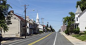
Jefferson is located in the southwestern part of Frederick County. It sits at the western base of Catoctin Mountain. Maryland Route 180 goes right through the community. U.S. Route 340 goes around Jefferson to the south, forming the southern edge of the CDP.
US 340 leads northeast about 9 miles to Frederick, which is the main city and county seat of Frederick County. It also leads southwest about 13 miles to Harpers Ferry, West Virginia.
According to the U.S. Census Bureau, the Jefferson CDP covers an area of 5.4 square kilometers (about 2.1 square miles). All of this area is land.
Mar-Lu-Ridge Summer Camp
The Mar-Lu-Ridge Summer Camp and Education and Conference Center is located on top of Catoctin Mountain. It's about 4 miles south of Jefferson. This center has been a popular retreat and outdoor ministry site for the Evangelical Lutheran Church in America since 1959.
Population and Demographics
| Historical population | |||
|---|---|---|---|
| Census | Pop. | %± | |
| 2020 | 2,697 | — | |
| U.S. Decennial Census | |||
Notable People from Jefferson
- Debbie Ricker (born 1965), a scientist who studies reproduction and a university leader.
See also
 In Spanish: Jefferson (Maryland) para niños
 | Toni Morrison |
 | Barack Obama |
 | Martin Luther King Jr. |
 | Ralph Bunche |


