Burkittsville, Maryland facts for kids
Quick facts for kids
Burkittsville, Maryland
|
|||
|---|---|---|---|
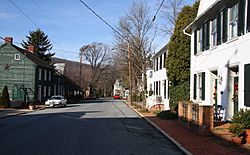
Main Street in Burkittsville
|
|||
|
|||
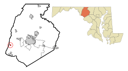
Location of Burkittsville, Maryland
|
|||
| Country | United States | ||
| State | Maryland | ||
| County | Frederick | ||
| Incorporated | 1894 | ||
| Area | |||
| • Total | 0.46 sq mi (1.19 km2) | ||
| • Land | 0.45 sq mi (1.18 km2) | ||
| • Water | 0.00 sq mi (0.01 km2) | ||
| Elevation | 551 ft (168 m) | ||
| Population
(2020)
|
|||
| • Total | 142 | ||
| • Density | 312.78/sq mi (120.70/km2) | ||
| Time zone | UTC−05:00 (Eastern (EST)) | ||
| • Summer (DST) | UTC−04:00 (EDT) | ||
| ZIP Code |
21718
|
||
| Area code(s) | 301, 240 | ||
| FIPS code | 24-11400 | ||
| GNIS feature ID | 2390762 | ||
Burkittsville is a small, historic village in Frederick County, Maryland, United States. It is located in the southern part of the Middletown Valley. This valley sits at the eastern base of South Mountain.
Burkittsville is mostly a residential area. Its economy relies on farming and tourism. The village was an important site during the Civil War. The Battle of Crampton's Gap happened here on September 14, 1862. This battle was part of the larger Battle of South Mountain during the Maryland Campaign. Burkittsville also became famous as the setting for the 1999 horror movie The Blair Witch Project. You can find fun places nearby like Gathland State Park and the Appalachian Trail. There's even a Gravity hill on Gapland Road, which makes things look like they roll uphill!
In 2020, about 142 people lived in Burkittsville.
Contents
History of Burkittsville
People from England started settling in this area in the early 1700s. Land was being measured and claimed in the Middletown Valley starting in the 1720s. The first piece of land within what is now Burkittsville was called "Dawson's Purchase." It was claimed on May 14, 1741. The Harley/Arnold Farm, which is on the western edge of the village, is on this original land.
How Burkittsville Started
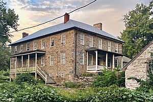
Burkittsville was first created by two landowners: Major Joshua Harley and Henry Burkitt. The western part of the village was first called "Harley's Post Office" in 1824. After Major Harley passed away in 1828, Henry Burkitt renamed the area Burkittsville. Over the next 30 years, the community grew. It had stores, shops, blacksmiths, a schoolhouse, and a tannery.
Burkittsville and the Civil War
On September 13, 1862, soldiers from the Confederate army, led by Colonel Thomas Munford, took over Burkittsville. The next day, September 14, the Union and Confederate armies fought the Battle of Crampton's Gap. This was a very important battle that happened just before the famous Battle of Antietam.
The local Reformed and Lutheran churches, along with the schoolhouse, were used as hospitals. More than 300 wounded soldiers from both sides were cared for there. These buildings are still standing today.
Winning at Crampton's Gap was a key part of the Union army's plan. Union General George B. McClellan had found a secret order from Confederate General Robert E. Lee. This order showed Lee's army movements. McClellan wanted to "cut the enemy in two" and defeat them.
After taking Crampton's Gap, General William B. Franklin's Union forces did not manage to help the Union soldiers at Harpers Ferry. They also failed to stop Confederate Generals James Longstreet and "Stonewall" Jackson from joining up again at Sharpsburg. This led to the huge Battle of Antietam, which was the bloodiest single day in American history. After this battle, President Abraham Lincoln used the Union's small victory to announce the Emancipation Proclamation. This changed the goals of the war. Without the fall of Crampton's Gap, the Battle of Antietam might not have happened.
Burkittsville's Historic District
Almost all of Burkittsville is a historic district. This means it's a special area recognized for its history. It was added to the National Register of Historic Places on November 20, 1975. The district covers about 300 acres (121 hectares) and includes about 70 important historic buildings. The Burkittsville Historic District is also part of a larger area called the Crampton's Gap Historic District. This larger district covers the southern part of the lands where the Battle of South Mountain took place.
Geography of Burkittsville
Burkittsville covers a total area of about 0.45 square miles (1.17 square kilometers). Almost all of this area is land.
Transportation in Burkittsville
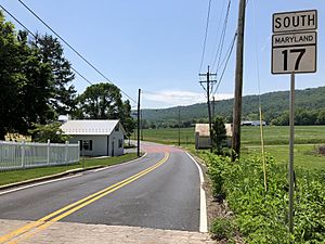
The main way to travel to and from Burkittsville is by road. The most important highway serving the town is Maryland Route 17. This road is called Potomac Street within the town. To the north, MD 17 connects to Middletown. It eventually reaches Interstate 70 near Myersville. If you head south on MD 17, it connects with U.S. Route 340 before reaching Brunswick.
Population of Burkittsville
| Historical population | |||
|---|---|---|---|
| Census | Pop. | %± | |
| 1870 | 293 | — | |
| 1880 | 280 | −4.4% | |
| 1890 | 273 | −2.5% | |
| 1900 | 229 | −16.1% | |
| 1910 | 228 | −0.4% | |
| 1920 | 200 | −12.3% | |
| 1930 | 173 | −13.5% | |
| 1940 | 177 | 2.3% | |
| 1950 | 190 | 7.3% | |
| 1960 | 208 | 9.5% | |
| 1970 | 221 | 6.3% | |
| 1980 | 202 | −8.6% | |
| 1990 | 194 | −4.0% | |
| 2000 | 171 | −11.9% | |
| 2010 | 151 | −11.7% | |
| 2020 | 142 | −6.0% | |
| U.S. Decennial Census | |||
2010 Census Information
According to the 2010 census, there were 151 people living in Burkittsville. These people lived in 69 households, and 42 of these were families. The town had about 336 people per square mile (130 people per square kilometer).
Most of the people living in Burkittsville were White (99.3%). A small number (0.7%) were Asian. About 1.3% of the population identified as Hispanic or Latino.
The average age of people in the town was 50.5 years old. About 15.9% of residents were under 18 years old. About 15.2% were 65 years or older. The population was almost evenly split between males (50.3%) and females (49.7%).
Things to See and Do
- P.J. Gilligan Dry Goods & Mercantile Co. (built in 1821)
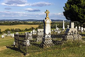
- Burkittsville Union Cemetery
- South Mountain Heritage Society Museum (opened in 2002)
- Spook Hill Cider & Wine 4-Mile Run
See also
 In Spanish: Burkittsville para niños
 | Kyle Baker |
 | Joseph Yoakum |
 | Laura Wheeler Waring |
 | Henry Ossawa Tanner |


