Rosemont, Maryland facts for kids
Quick facts for kids
Rosemont, Maryland
|
||
|---|---|---|
|
Village
|
||
| Village of Rosemont | ||

Rosemont
|
||
|
||
 |
||
| Country | ||
| State | ||
| County | ||
| Incorporated | 1953 | |
| Government | ||
| • Type | Municipality | |
| Area | ||
| • Total | 0.56 sq mi (1.44 km2) | |
| • Land | 0.56 sq mi (1.44 km2) | |
| • Water | 0.00 sq mi (0.00 km2) | |
| Elevation | 495 ft (151 m) | |
| Population
(2020)
|
||
| • Total | 272 | |
| • Density | 489.21/sq mi (188.81/km2) | |
| Time zone | UTC-5 (Eastern (EST)) | |
| • Summer (DST) | UTC-4 (EDT) | |
| FIPS code | 24-68600 | |
| GNIS feature ID | 2391099 | |
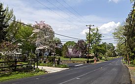
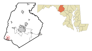
Rosemont is a small village located in Frederick County, Maryland, in the United States. In 2020, about 272 people lived there. Even though it's a small place, it's an official village, which means it has its own local government. Main roads like Route 79 and Route 871 go through Rosemont.
Village Geography
Rosemont covers a total area of about 1.44 square kilometers (0.56 square miles). All of this area is land, meaning there are no large lakes or rivers within the village limits.
Getting Around Rosemont
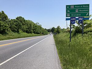
Most people travel to and from Rosemont by car. Even though it's a small village, four different state highways serve the area.
- Maryland Route 17: This important road runs along the southwest side of the village. It goes south to Brunswick and then crosses the Potomac River into Virginia. To the north, Route 17 connects with U.S. Route 340. It then continues to towns like Burkittsville, Middletown, and Myersville, where it meets Interstate 70.
- Other State Highways: Other roads that help people get around Rosemont include Maryland Route 79, Maryland Route 464, and Maryland Route 871.
Village Population
The population of Rosemont has changed over the years. Here's how many people have lived there during different census counts:
| Historical population | |||
|---|---|---|---|
| Census | Pop. | %± | |
| 1960 | 212 | — | |
| 1970 | 250 | 17.9% | |
| 1980 | 223 | −10.8% | |
| 1990 | 256 | 14.8% | |
| 2000 | 273 | 6.6% | |
| 2010 | 294 | 7.7% | |
| 2020 | 272 | −7.5% | |
| U.S. Decennial Census | |||
Population in 2010
In 2010, the village had 294 people living in 114 households. About 84 of these were families. The village had about 210 housing units per square mile.
Most people in Rosemont were White (92.9%). A small number were African American (1.4%), Asian (0.3%), or Pacific Islander (0.3%). Some people were from other backgrounds (0.7%) or mixed races (4.4%). About 1.4% of the population identified as Hispanic or Latino.
- Households: About 22.8% of households had children under 18 living with them. Most households (58.8%) were married couples. Some households had a single female parent (9.6%) or a single male parent (5.3%). About 26.3% of households were not families.
- Living Alone: About 18.4% of all households had only one person living in them. Of these, 10.6% were people aged 65 or older living alone.
- Average Size: The average household had 2.58 people, and the average family had 2.93 people.
- Age: The average age in the village was 49.6 years old.
- 14.6% of residents were under 18.
- 8.2% were between 18 and 24.
- 19% were between 25 and 44.
- 38.4% were between 45 and 64.
- 19.7% were 65 or older.
- Gender: The population was almost evenly split between males (49.3%) and females (50.7%).
See also
 In Spanish: Rosemont (Maryland) para niños
 | James Van Der Zee |
 | Alma Thomas |
 | Ellis Wilson |
 | Margaret Taylor-Burroughs |


