Adamstown, Maryland facts for kids
Quick facts for kids
Adamstown
|
|
|---|---|

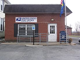
The Adamstown post office in March 2004
|
|
 |
|
| Country | |
| State | |
| County | |
| First named | 1840 |
| Area | |
| • Total | 1.06 sq mi (2.76 km2) |
| • Land | 1.06 sq mi (2.76 km2) |
| • Water | 0.00 sq mi (0.00 km2) |
| Elevation | 312 ft (95 m) |
| Population
(2020)
|
|
| • Total | 2,331 |
| • Density | 2,190.79/sq mi (845.87/km2) |
| ZIP code |
21710
|
| Area codes | 240 and 301 |
| FIPS code | 24-00350 |
| GNIS feature ID | 2583568 |
Adamstown is a small community in Frederick County, Maryland, United States. It's called an "unincorporated community" and a "census-designated place" (CDP). This means it's a recognized area for gathering census data, but it doesn't have its own local government like a city or town.
Adamstown got its name from Adam Kohlenberg. He was an important person in the early days of the community. He worked as a station agent for the railroad and was also the first merchant in town. In 2010, about 2,372 people lived in Adamstown.
Contents
History of Adamstown
Adamstown is located in a rich valley between two mountains: Sugarloaf and Catoctin Mountain. This area was once part of a huge estate called Carrollton Manor. It covered about 17,000 acres (about 69 square kilometers).
For a long time, Adamstown looked much like it did in the mid-1800s. It has many different kinds of old buildings. You can find homes, shops, factories, schools, farm buildings, and churches there.
How Adamstown Began
An old road from Jefferson to Greenfield Mills followed the path of today's Mountville Road. In 1832, the railroad arrived in the area. This was a big deal! It brought new ways to transport goods and helped the community grow.
Adamstown was first known as "Davis' Warehouse." Around 1835, a Quaker miller named Dr. Meredith Davis built a warehouse here. He used it to store flour from his mills. The warehouse was located where Mountville Road crossed the Baltimore and Ohio Railroad.
The very first person to settle in Adamstown was Robert Palmer. He was an African American man who also ran a general store around 1835.
Naming the Town
In 1840, Adam Kohlenburg became the first railway agent for the Baltimore and Ohio Railroad. Because of him, the community started to be called "Adamstown." He was also the first postmaster and ran a general store. This store was located near his brick home and the railroad tracks.
Later, in the 1840s, Edward Hebb created building lots on the north side of the railroad. In 1856, Daniel Rhodes from Pennsylvania bought land on the south side of the railroad. He divided it into 12 building lots.
Adamstown During the Civil War
Adamstown was close to the Potomac River and Virginia. During the American Civil War, many people in Adamstown supported the Southern states. Both Union and Confederate soldiers were often in the area.
For a few months in 1861, a local group called the Minute Men of Adamstown flew the Confederate flag near the railroad. The town saw many small battles and was often raided. One famous group, Mosby's Rangers, raided the town in 1864. During one of these raids, Adam Kohlenburg's store lost all its goods.
Local stories say that one family in Adamstown had a son fighting for the North and another fighting for the South.
Growth in the 1900s
In 1902, more areas were added to Adamstown, including Washington, Adams, and Tuscarora streets. The Adamstown Bank opened in 1917. By 1921, Adamstown had several businesses. These included two large grain elevators, a blacksmith shop, a carriage works, two garages, a general store, a hardware store, a butcher shop, and the bank. Electric lights were also installed in the town in 1921.
Population and People
| Historical population | |||
|---|---|---|---|
| Census | Pop. | %± | |
| 2020 | 2,331 | — | |
| U.S. Decennial Census | |||
Adamstown has grown over the years. In 1880, only 66 people lived there. By 1971, the population was about 500.
Since the year 2000, three new housing developments have been built in Adamstown. These are Green Hill Manor, Saddle Ridge, and Adamstown Commons. They added a total of 540 new homes.
According to the census in 2000, there were 2,920 people living in Adamstown. Most people were White (92.7%). About 4.9% were Black or African American. A small number of people were Native American, Asian, or from other backgrounds. About 1.6% of the population was Hispanic or Latino.
Many families live in Adamstown. In 2000, about 36.4% of households had children under 18 living with them. The average household had about 2.77 people. The average family had about 3.12 people.
Education
Children in Adamstown attend Carroll Manor Elementary School. This school teaches students from pre-kindergarten up to 5th grade. Carroll Manor Elementary also has special programs for children with autism and other communication needs. There is also a special education pre-kindergarten. The school is supported by the Carroll Manor Elementary School PTA. After elementary school, students usually go to Ballenger Creek Middle School and then Tuscarora High School.
Geography
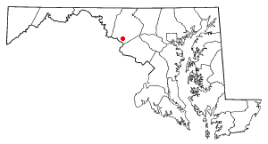
Adamstown is located in the southern part of Frederick County. It is about 9 miles (14.5 kilometers) southwest of Frederick, which is the county seat. It is also about 5 miles (8 kilometers) northeast of the Potomac River at Point of Rocks.
Highways
See also
 In Spanish: Adamstown (Maryland) para niños
 | Precious Adams |
 | Lauren Anderson |
 | Janet Collins |

