Point of Rocks, Maryland facts for kids
Quick facts for kids
Point of Rocks, Maryland
|
|
|---|---|

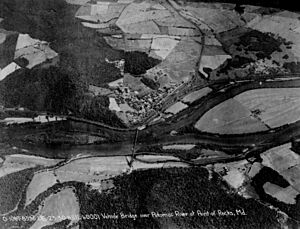
Aerial image, 1930
|
|

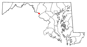
Location of Point of Rocks in Maryland
|
|
| Country | |
| State | |
| County | |
| Area | |
| • Total | 1.13 sq mi (2.92 km2) |
| • Land | 1.13 sq mi (2.92 km2) |
| • Water | 0.00 sq mi (0.00 km2) |
| Elevation | 276 ft (84 m) |
| Population
(2020)
|
|
| • Total | 1,886 |
| • Density | 1,674.96/sq mi (646.99/km2) |
| Time zone | UTC−5 (Eastern (EST)) |
| • Summer (DST) | UTC−4 (EDT) |
| ZIP Code |
21777
|
| Area code(s) | 301, 240 |
| FIPS code | 24-62575 |
| GNIS feature ID | 2583673 |
Point of Rocks is a small community in Frederick County, Maryland. It's called a "census-designated place" (CDP), which means it's a specific area the government counts for population. In 2010, about 1,466 people lived here.
The town gets its name from a cool rock formation on the nearby Catoctin Mountain. This formation was created when the Potomac River cut through the mountain, making a "water gap." You can't see this rock formation from the town itself. You need to be on a boat in the river or on the Virginia side to see it.
Contents
History of Point of Rocks

In 1828, there was a big argument over a narrow passage between the river and Catoctin Mountain. Two large companies, the Chesapeake and Ohio (C&O) Canal Company and the B&O Railroad, both wanted to build there.
After many years of disagreements, they finally found a way to share the space. Both the canal and the railroad were built through the passage. They even built a wall between them. This wall was to stop the trains from scaring the mules that pulled the canal boats!
Point of Rocks During the Civil War
During the American Civil War, Point of Rocks was often attacked. These attacks came from Confederate soldiers, like John S. Mosby, who operated from across the river in Loudoun County, Virginia.
The town was an important target because it had the B&O Railroad and the C&O Canal. Also, many people who supported the Union had moved there from Loudoun County.
In 1864, Mosby's Rangers arrived across the river from Point of Rocks. They found about 350 Union soldiers in the village. Some soldiers were on an island in the Potomac River. Others were in a small fort above the C&O Canal.
Mosby's Rangers first cleared the island. They used a small cannon and sharpshooters. The Union soldiers on the island retreated to the Maryland shore. They even broke a small bridge over the canal as they crossed.
The Rangers then quickly crossed the river to Maryland. They fixed the bridge and rushed into the town. They quickly drove the Union soldiers out.
After taking control, the Rangers burned canal boats. They also cut the telegraph wires that ran from Washington to Harpers Ferry. Point of Rocks was important because of its location. It was also a place where many Union supporters from Loudoun County lived.
The Rangers took supplies from the town's shops and warehouses. Some of these belonged to Union supporters. The raid became known as the "Calico Raid" because the Rangers returned with many nice clothes. After the raid, they went back to Virginia.
The next morning, Mosby sent some Rangers to take the supplies back to Fauquier County. He also sent a message to General Early, who was camped nearby. Mosby then planned to continue his raid into Maryland.
However, the Union army in Washington knew about the raid. They sent the 8th Illinois Cavalry to Point of Rocks. When Mosby's Rangers returned, they found the 8th Illinois holding the village. A long fight happened across the river. Mosby then decided to leave and head south. The 8th Illinois Cavalry later fought in the Battle of Monocacy.
Recent History and Landmarks
In 2001, a company called Duke Energy wanted to build a power plant near Point of Rocks. But in 2002, they decided not to build it.
The Point of Rocks railroad station is a very old and important building. It was added to the National Register of Historic Places in 1973. St. Paul's Episcopal Church was also listed in 1978.
Geography of Point of Rocks
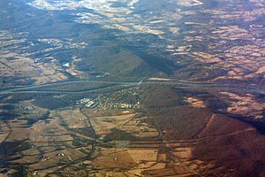
Point of Rocks is in the southern part of Frederick County. It sits on the north bank of the Potomac River. To its west is U.S. Route 15, which runs along the base of Catoctin Mountain.
If you travel north on US 15, it's about 13 miles to Frederick, the main town of the county. If you go south, it's about 12 miles across the Potomac River to Leesburg, Virginia. Maryland Route 28 goes east from Point of Rocks. It leads through rural areas for about 29 miles to Rockville, Maryland.
The U.S. Census Bureau says that Point of Rocks covers about 2.85 square kilometers (1.10 square miles) of land. There is no water area.
Population of Point of Rocks
| Historical population | |||
|---|---|---|---|
| Census | Pop. | %± | |
| 2020 | 1,886 | — | |
| U.S. Decennial Census | |||
In 2020, the population of Point of Rocks was 1,886 people.
Transportation in Point of Rocks
Bridges and Roads
The community has the Point of Rocks Bridge for U.S. Route 15. This bridge crosses the Potomac River into Virginia. It's the first bridge upstream from the American Legion Memorial Bridge near Washington, D.C. The only other way to cross the river between them is White's Ferry.
Railroad History and Service
Train service started in Point of Rocks in 1834. This was when the Baltimore and Ohio Railroad's main line opened. The line first ended nearby in Sandy Hook, Maryland. Later, in 1839, the Harpers Ferry Crossing opened, allowing trains to cross the Potomac into Virginia.
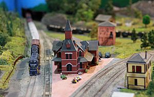
Today, Point of Rocks is a stop on the MARC Brunswick Line. The train station was built in 1876. It was designed by Ephraim Francis Baldwin for the Baltimore and Ohio (B&O). This station is a famous landmark for railroad fans. It marks where two important train lines meet.
Notable Person
- Craig Davis, an author and expert in international development.
See also
 In Spanish: Point of Rocks (Maryland) para niños
 | Stephanie Wilson |
 | Charles Bolden |
 | Ronald McNair |
 | Frederick D. Gregory |


