
Rockville, Maryland facts for kids
Quick facts for kids
Rockville, Maryland
|
|||||
|---|---|---|---|---|---|
| The Mayor and Council of Rockville | |||||

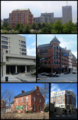
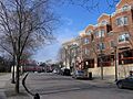
Downtown Rockville in 2001, the Montgomery County Judicial Center in 2010, the Rockville Town Square in 2010, the Beall-Dawson House in 2005, and downtown Rockville in 2008
|
|||||
|
|||||

Location in Montgomery County and Maryland
|
|||||

Rockville, Maryland
Location in Maryland

Rockville, Maryland
Location in the United States
|
|||||
| Country | |||||
| State | |||||
| County | |||||
| Settled | 1717 | ||||
| Founded | 1803 | ||||
| Incorporated | 1860 | ||||
| Government | |||||
| • Type | Council–manager | ||||
| Area | |||||
| • Total | 13.64 sq mi (35.33 km2) | ||||
| • Land | 13.60 sq mi (35.23 km2) | ||||
| • Water | 0.04 sq mi (0.09 km2) | ||||
| Elevation | 449 ft (137 m) | ||||
| Population
(2020)
|
|||||
| • Total | 67,117 | ||||
| • Density | 4,933.62/sq mi (1,904.92/km2) | ||||
| Time zone | UTC−5 (EST) | ||||
| • Summer (DST) | UTC−4 (EDT) | ||||
| ZIP Codes |
20847–20853 & 20857
|
||||
| Area codes | 301, 240 | ||||
| FIPS code | 24-67675 | ||||
| GNIS feature ID | 2390645 | ||||


Rockville is a city in Montgomery County, Maryland, in the United States. It is the main city of the county, meaning it's where the local government is located. Rockville is also part of the larger Washington metropolitan area.
In 2020, about 67,117 people lived in Rockville. This makes it the fourth-largest city in Maryland. Rockville, along with nearby Gaithersburg and Bethesda, is a major center for technology. Many software and biotechnology companies are located here. You can also find several important government offices in the area. Rockville is also a big shopping spot in Montgomery County, with many popular shopping centers.
Contents
- History of Rockville
- Geography and Climate of Rockville
- People and Economy in Rockville
- Rockville's Economy and Jobs
- Sports and Recreation in Rockville
- Education in Rockville
- Transportation in Rockville
- Law Enforcement in Rockville
- Famous People from Rockville
- Sister Cities of Rockville
- Images for kids
- See also
History of Rockville
Early Days: Native Americans and First Settlers
Rockville is located in a hilly area called the Piedmont region. It has three creeks: Rock Creek, Cabin John Creek, and Watts Branch. These creeks made it a great place for early Native Americans to live. They were semi-nomadic, meaning they moved around. Some groups settled down into farming communities around 8000 BC. They grew plants like sunflowers.
Around 1200 AD, these groups, sometimes called Montgomery Indians, faced conflicts. Other tribes like the Senecas and Susquehannocks moved south. Over time, six ancient sites have been found in Rockville. Many old tools and items, thousands of years old, have also been discovered. By 1700, most of the original people had left due to European settlers.
Native Americans created a path on high ground, called Sinequa Trail. This trail is now where downtown Rockville is. Later, a main road, the Rock Creek Main Road, was built here. In the mid-1700s, Lawrence Owen opened a small inn called Owen's Ordinary. This inn became important when Major General Edward Braddock stopped there in 1755. He was on a mission from George Town (now Washington, D.C.). The road's high location kept it dry all year.
The 1700s: How Rockville Got Its Start
The first land claims in the Rockville area were made by Arthur Nelson between 1717 and 1735. Within 30 years, the first permanent buildings were built in what would become Rockville. At first, Rockville was part of Prince George's County. But as nearby Frederick Town grew, the western part of the county, including Rockville, became Frederick County in 1748.
Because it was a small, unincorporated town (meaning it didn't have its own official government yet), early Rockville had many names. People called it Owen's Ordinary, Hungerford's Tavern, or Daley's Tavern. The first time the settlement was written about was during the Braddock Expedition in 1755. A soldier wrote about marching to "Owings Oardianary," calling it "a Single House, it being 18 miles and very dirty." Owen's Ordinary was a small stop on Rock Creek Main Road. This road went from George Town to Frederick Town. It was one of the busiest roads in Maryland at the time.
On September 6, 1776, Maryland decided to divide Frederick County into three smaller areas. Rockville was in the southern part, which was named Montgomery County. George Town was the biggest town in this new county. But it was too far south to be the county seat (the center of local government). Rockville was small but centrally located and well-traveled. So, it was chosen as the county seat. At this time, Rockville still didn't have an official name. People often called it Hungerford's Tavern. After it became the county seat, people started calling it Montgomery Court House. The tavern served as the first courthouse on May 20, 1777.
In 1784, a local landowner named William Prather Williams hired someone to map out the town. In his honor, many started calling the town Williamsburg. But people still used Williamsburg and Montgomery Court House interchangeably. Rockville became more important when Montgomery County was created. It also grew when George Town was given to the federal government to create the District of Columbia.
The 1800s: Naming the City and Civil War Times
A plan to name the town Wattsville, after the nearby Watts Branch creek, didn't happen. People thought the creek was too small to name the town after. On July 16, 1803, the area was officially recorded as "Rockville." This name came from Rock Creek. Even so, the name Montgomery Court House still appeared on maps until the 1820s.


On March 10, 1860, Rockville officially became an incorporated village. This meant it had its own local government. During the American Civil War, General George B. McClellan stayed at the Beall Dawson house in 1862. Also, General J.E.B. Stuart and 8,000 Confederate soldiers marched through Rockville. They occupied the town on June 28, 1863, on their way to the Battle of Gettysburg. They stayed at the Prettyman house. Another general, Jubal Anderson Early, also passed through Rockville in 1864.
In 1873, the Baltimore and Ohio Railroad came to Rockville. This made it easy to travel to and from Washington, D.C.. In 1891, Rockville got its first trolley service. It connected to a railway line that went to Georgetown.
From the 1900s to Today: Growth and Changes


The new railroad and trolley service connected Rockville to Washington, D.C. Trolley service ran for 40 years. But by 1935, more people were using automobiles, so the trolley stopped. Bus service was available from 1924 to 1955. Rockville didn't have much public transportation again until the 1970s. That's when the Washington Metropolitan Area Transit Authority (WMATA) started extending the Washington Metro subway system.
The Rockville Metro station opened on July 25, 1984. The Twinbrook station opened on December 15, 1984. Metrobus service also expanded into Montgomery County. In 1979, Montgomery County started its own Ride On bus service. The MARC commuter train also serves Rockville. It connects to Washington Union Station in Washington D.C. and to Frederick. Amtrak, the national passenger train system, also has service from Rockville to Chicago and Washington D.C.
Rockville grew a lot in the mid-1900s. The Twinbrook area became part of the city in 1949. This added hundreds of new homes and thousands of residents. In 1954, Congressional Airport closed. Its land was used to build homes and a shopping center called Congressional Plaza, which opened in 1958. These new areas offered affordable homes for young families after World War II.
During the Cold War, people thought it was safer to stay in Rockville. This was in case of a nuclear attack on Washington, D.C. Bomb shelters were built, including a large one at Glenview Mansion. The I-270 highway was even planned as an emergency landing strip for aircraft.
From the 1960s, Rockville's town center started to decline. It used to be a main shopping area. Rockville became the first city in Maryland to try a government-funded urban renewal program. This meant tearing down most of the old business district. They built the Rockville Mall, but it didn't do well and was torn down in 1994. They also built new government buildings, like the Montgomery County Judicial Center.
Even though the plan had problems, efforts to improve the town center continued. Most of the city's business activity moved along Rockville Pike. In 2004, Rockville Mayor Larry Giammo announced plans to update the Rockville Town Square. This included new stores, homes, and moving the city's library. Today, the new Rockville Town Center has many unique stores, restaurants, and apartments. It also has stages, fountains, and the Rockville Library. The U.S. Nuclear Regulatory Commission's main office is just south of the city.
Rockville is also connected to nearby towns like Kensington and North Bethesda. The Music Center at Strathmore, an arts center, opened in 2005. It is a second home for the Baltimore Symphony Orchestra. The Fitzgerald Theatre in Rockville Civic Center Park has offered entertainment since 1960. In 1998, Regal Cinemas opened in the Town Center, and the city added 900 acres of land.
Rockville also has a brass band that plays in the British style. The band R.E.M. released a song in 1984 called "(Don't Go Back To) Rockville". It was written about not wanting someone to return to Rockville. In 1975, the famous writer F. Scott Fitzgerald and his wife Zelda Fitzgerald were buried at St. Mary's Catholic Church in Rockville.
Historic Places to Visit
Many historic buildings in and around Rockville are listed on the National Register of Historic Places. These are important places that have been preserved.
- Beall–Dawson House (built in 1815)
- Bingham-Brewer House (built in 1821)
- Dawson Farm (built in 1874)
- Glenview Mansion (built in 1926)
- Montgomery County Courthouse Historic District (built in 1939)
- New Mark Commons (built in 1967)
- Old St. Mary's Church (built in 1817)
- Rockville Park Historic District (built in 1884)
- Rockville Railroad Station (built in 1873)
- West Montgomery Avenue Historic District (built in 1880)
Historic Places Near Rockville
- Montrose Schoolhouse (built in 1909)
Geography and Climate of Rockville

Rockville covers about 13.57 square miles (35.15 square kilometers). Most of this area is land, with a small amount of water.
What's the Weather Like?
Rockville has hot, humid summers. Winters are usually mild to cool. This type of weather is called a humid subtropical climate. The average lowest winter temperature is between 0 and 5 degrees Fahrenheit (-18 to -15 degrees Celsius). The first frost usually happens around October 21. The last frost is typically around April 16.
| Climate data for Rockville, Maryland, 1981–2010 normals, extremes 1907–2007 | |||||||||||||
|---|---|---|---|---|---|---|---|---|---|---|---|---|---|
| Month | Jan | Feb | Mar | Apr | May | Jun | Jul | Aug | Sep | Oct | Nov | Dec | Year |
| Record high °F (°C) | 78 (26) |
82 (28) |
89 (32) |
100 (38) |
97 (36) |
102 (39) |
105 (41) |
104 (40) |
99 (37) |
93 (34) |
85 (29) |
80 (27) |
105 (41) |
| Mean maximum °F (°C) | 62.7 (17.1) |
67.4 (19.7) |
77.8 (25.4) |
84.9 (29.4) |
89.0 (31.7) |
92.5 (33.6) |
95.0 (35.0) |
93.0 (33.9) |
89.5 (31.9) |
80.7 (27.1) |
74.3 (23.5) |
65.4 (18.6) |
96.2 (35.7) |
| Mean daily maximum °F (°C) | 40.4 (4.7) |
43.7 (6.5) |
53.3 (11.8) |
64.5 (18.1) |
72.8 (22.7) |
81.3 (27.4) |
85.0 (29.4) |
83.2 (28.4) |
75.8 (24.3) |
64.8 (18.2) |
54.7 (12.6) |
43.8 (6.6) |
63.6 (17.6) |
| Daily mean °F (°C) | 33.7 (0.9) |
36.4 (2.4) |
44.8 (7.1) |
55.2 (12.9) |
63.8 (17.7) |
72.8 (22.7) |
76.9 (24.9) |
75.2 (24.0) |
67.7 (19.8) |
56.2 (13.4) |
46.9 (8.3) |
37.2 (2.9) |
55.6 (13.1) |
| Mean daily minimum °F (°C) | 27.0 (−2.8) |
29.2 (−1.6) |
36.2 (2.3) |
45.9 (7.7) |
54.8 (12.7) |
64.3 (17.9) |
68.8 (20.4) |
67.2 (19.6) |
59.7 (15.4) |
47.7 (8.7) |
39.1 (3.9) |
30.5 (−0.8) |
47.5 (8.6) |
| Mean minimum °F (°C) | 5.4 (−14.8) |
8.5 (−13.1) |
16.2 (−8.8) |
27.4 (−2.6) |
36.8 (2.7) |
45.8 (7.7) |
52.2 (11.2) |
50.7 (10.4) |
40.4 (4.7) |
29.4 (−1.4) |
21.0 (−6.1) |
11.9 (−11.2) |
1.8 (−16.8) |
| Record low °F (°C) | −13 (−25) |
−12 (−24) |
1 (−17) |
18 (−8) |
28 (−2) |
35 (2) |
38 (3) |
39 (4) |
28 (−2) |
20 (−7) |
10 (−12) |
−12 (−24) |
−13 (−25) |
| Average precipitation inches (mm) | 2.88 (73) |
2.71 (69) |
3.61 (92) |
3.22 (82) |
4.13 (105) |
3.49 (89) |
3.67 (93) |
2.90 (74) |
3.83 (97) |
3.29 (84) |
3.53 (90) |
3.00 (76) |
40.26 (1,024) |
| Average snowfall inches (cm) | 8.3 (21) |
3.4 (8.6) |
2.6 (6.6) |
0.1 (0.25) |
0.0 (0.0) |
0.0 (0.0) |
0.0 (0.0) |
0.0 (0.0) |
0.0 (0.0) |
0.0 (0.0) |
0.5 (1.3) |
2.2 (5.6) |
17.1 (43.35) |
| Average precipitation days (≥ 0.01 in) | 9.7 | 8.1 | 10.7 | 10.1 | 11.8 | 9.7 | 10.0 | 7.8 | 9.0 | 8.0 | 8.2 | 8.9 | 112.0 |
| Average snowy days (≥ 0.1 in) | 3.0 | 1.9 | 1.1 | 0.1 | 0.0 | 0.0 | 0.0 | 0.0 | 0.0 | 0.0 | 0.3 | 1.3 | 7.7 |
| Source: NOAA (mean maxima/minima 1971–2000) | |||||||||||||
People and Economy in Rockville
Population Growth Over Time
Rockville has grown a lot over the years. Here's how its population has changed:
| Historical population | |||
|---|---|---|---|
| Census | Pop. | %± | |
| 1900 | 1,110 | — | |
| 1910 | 1,181 | 6.4% | |
| 1920 | 1,145 | −3.0% | |
| 1930 | 1,422 | 24.2% | |
| 1940 | 2,047 | 44.0% | |
| 1950 | 6,934 | 238.7% | |
| 1960 | 26,090 | 276.3% | |
| 1970 | 42,739 | 63.8% | |
| 1980 | 43,811 | 2.5% | |
| 1990 | 44,835 | 2.3% | |
| 2000 | 47,388 | 5.7% | |
| 2010 | 61,209 | 29.2% | |
| 2020 | 67,117 | 9.7% | |
| U.S. Decennial Census 2010–2020 |
|||
Understanding the Community
In 2020, the average income for a household in Rockville was $111,797. For families, it was $98,257 in 2007. About 7.8% of the people and 5.6% of families lived below the poverty line. This means they had very low incomes.
Based on the 2010 census, there were 61,209 people living in Rockville. There were 23,686 households, which are groups of people living together. The city had about 4,530 people per square mile.
The people living in Rockville come from many different backgrounds. About 60.4% were White, 9.6% African American, and 20.6% Asian. About 14.3% of the population was Hispanic or Latino.
The average age in Rockville was 38.7 years. About 21.5% of residents were under 18 years old. And 14% were 65 years or older. The city had slightly more females (52.1%) than males (47.9%).
Rockville's Economy and Jobs
Choice Hotels, Westat, and Bethesda Softworks/ZeniMax Media have their main offices in Rockville. These are big companies that provide many jobs.

Top Employers in the City
Here are the biggest employers in Rockville, based on a 2023 report:
| # | Employer | Employees |
|---|---|---|
| 1 | Montgomery County | 5,165 |
| 2 | Montgomery County Public Schools | 2,500 |
| 3 | U.S. Nuclear Regulatory Commission | 2,391 |
| 4 | Montgomery College | 2,000 |
| 5 | Westat | 1,750 |
| 6 | Northwestern Mutual Life Insurance | 623 |
| 7 | Lockheed Martin Information Systems | 565 |
| 8 | City of Rockville | 501 |
| 9 | Choice Hotels | 500 |
| 10 | Quest Diagnostics | 500 |
Sports and Recreation in Rockville
- The Rockville Express is a baseball team. They were champions of the Cal Ripken, Sr. Collegiate Baseball League in 2007.
- The Rockville Baseball Association is a youth baseball and softball group. It has offered programs every year since 1954.
- The city also has many sports leagues for adults and young people. These include softball, pickleball, soccer, kickball, and volleyball.
Education in Rockville
Rockville is part of the Montgomery County Public Schools system.
Public High Schools
- Thomas S. Wootton High School
- Richard Montgomery High School
- Rockville High School
Before schools were integrated in 1961, Black students went to George Washington Carver High School in Rockville. The John L. Gildner Regional Institute helps children with special educational needs.
Private Schools
St. Elizabeth Catholic School is in Rockville. Other private schools with Rockville addresses include:
- Charles E. Smith Jewish Day School (in North Bethesda)
- Melvin J. Berman Hebrew Academy (in Aspen Hill)
Colleges and Universities
The main campus of Montgomery College (MC) is in Rockville. Over 15,000 students attend this college. It is approved by the Middle States Association of Colleges and Schools.
Other colleges and universities in Rockville include:
- The University of Maryland Global Campus
- The Johns Hopkins University Montgomery County Campus
- The Universities at Shady Grove, which is a group of nine Maryland public colleges.
Public Library Services
The Rockville Memorial Library serves the people of Rockville. It offers books, databases, newspapers, magazines, and internet access.
Transportation in Rockville
_from_the_overpass_for_West_Gude_Drive_in_Rockville,_Montgomery_County,_Maryland.jpg)
Main Roads and Highways
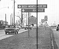
The most important highway in Rockville is Interstate 270. This highway leads northwest from the Washington, D.C. area. It starts at Interstate 495 and goes to Interstate 70 in Frederick. Maryland Route 355 was the older main road before I-270. It now serves as the main shopping road through Rockville. Other state highways in Rockville include Maryland Route 28, Maryland Route 189, Maryland Route 586, Maryland Route 660, and Maryland Route 911.
Public Transportation Options
You can use the Washington Metro Red Line subway system at the Rockville station and Twinbrook station. The Brunswick Line of the MARC commuter rail system also runs through Rockville. It goes to and from Washington, D.C.. Amtrak trains also stop in Rockville.
Bus services connect Rockville to the Baltimore–Washington International Airport and downtown Baltimore. Ride On buses provide service within Rockville and to other places in the county like Gaithersburg and Silver Spring.
Law Enforcement in Rockville
The Rockville City Police Department keeps the city safe. They are also helped by the Montgomery County Police Department.
Famous People from Rockville
Many well-known people have lived in or are connected to Rockville:
- Tori Amos, a singer-songwriter and pianist
- BT, a musician
- Gordy Coleman, a Major League Baseball player
- Jerome Dyson, a professional basketball player
- Elden Henson, an actor known for The Mighty Ducks movies
- Spike Jonze, a film director
- Charles Lazarus, who founded Toys "R" Us and opened the first store in Rockville
- Logic, a rapper and record producer
- Helen Maroulis, an Olympic wrestler
- Rachel Parsons, a figure skater
- Haley Skarupa, a professional ice hockey player
- Josh Tillman ("Father John Misty"), a musician
- James Wood, a professional baseball player
Sister Cities of Rockville
Rockville has two sister cities. These are cities in other countries that have a special friendship with Rockville.
 Pinneberg, Schleswig-Holstein, Germany
 Yilan City, Yilan County, Taiwan
Rockville also has friendly relations with another city:
 Jiaxing, Zhejiang Province, China
Images for kids
-
Downtown Rockville in 2001, the Montgomery County Judicial Center in 2010, the Rockville Town Square in 2010, the Beall-Dawson House in 2005, and downtown Rockville in 2008
-

The official flag of Rockville.
-
The official seal of Rockville.
-

The wordmark logo for Rockville.
-
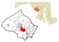
A map showing Rockville's location in Montgomery County.
-
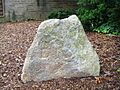
A stone marker from 1803 when Rockville's streets were first laid out.
-
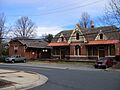
The Rockville Railroad Station, built in 1873.
-
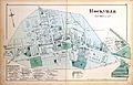
A map of Rockville from 1879.
-
Downtown Rockville in 1970.
-
Downtown Rockville in 2001.
-
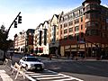
Rockville Town Center in 2006.
-
Downtown Rockville in 2009.
-
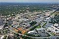
A view of Rockville, Maryland, looking Northwest.
-
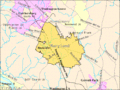
A map showing the boundaries of Rockville in 2004.
-

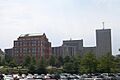
The Tower Building in Rockville, looking West.
-

Interstate 270 northbound in Rockville.
See also
 In Spanish: Rockville (Maryland) para niños
