Kensington, Maryland facts for kids
Quick facts for kids
Kensington, Maryland
|
|||
|---|---|---|---|
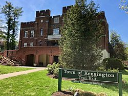
Kensington Town Hall
|
|||
|
|||
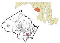
Location of Kensington in Montgomery County and Maryland
|
|||
| Country | |||
| State | |||
| County | |||
| Incorporated | 1894 | ||
| Area | |||
| • Total | 0.50 sq mi (1.30 km2) | ||
| • Land | 0.50 sq mi (1.30 km2) | ||
| • Water | 0.00 sq mi (0.00 km2) | ||
| Elevation | 299 ft (91 m) | ||
| Population
(2020)
|
|||
| • Total | 2,122 | ||
| • Density | 4,218.69/sq mi (1,630.37/km2) | ||
| Time zone | UTC-5 (Eastern (EST)) | ||
| • Summer (DST) | UTC-4 (EDT) | ||
| ZIP code |
20895
|
||
| Area codes | 301, 240 | ||
| FIPS code | 24-43500 | ||
| GNIS feature ID | 2391252 | ||
Kensington is a town in Montgomery County, Maryland, in the United States. In 2020, about 2,122 people lived there. The larger area known as Greater Kensington, which shares the 20895 ZIP code, had a population of 19,753 in 2020.
Contents
History of Kensington
The area where Kensington is located was mostly farmland until 1873. That's when the B&O Railroad built a new train line across Montgomery County. A small community started to grow where the new railroad crossed an old road. This early settlement was first called "Knowles Station."
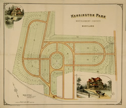
In the early 1890s, a developer from Washington named Brainard Warner started buying land. He wanted to build a planned community with a church, library, and even a local newspaper. Warner had recently visited London and was very impressed. So, he named his new development "Kensington Park." It was the tenth and largest neighborhood he developed in the area. When the town officially became a town in 1894, Warner convinced the leaders to name it Kensington.
Kensington began as a farming area at Knowles Station. Later, it became a popular summer escape for people from Washington, D.C., who wanted to get away from the hot weather. As more people started living there all year, Kensington grew into a commuter suburb. This means many people lived in Kensington but traveled to jobs in downtown Washington, D.C. They used B&O passenger trains and, starting in 1895, a streetcar line.
The oldest part of Kensington, which Warner planned, still looks much the same today. It is a historically protected area. The main changes over time include a bridge built over the railroad crossing in 1937. Also, Connecticut Avenue, the town's main road, was made longer and wider in 1957. The path of the old streetcar line, which stopped running in 1935, was paved and became Kensington Parkway.
In 1980, the historic center of Kensington was added to the National Register of Historic Places. This means it's recognized as an important historical site.
In the early 2000s, Kensington gained national attention a few times. In 2001, there was a big protest when Santa Claus was briefly banned from the annual holiday parade. Many people, including dozens of Santas, showed up to protest. In 2002, an Amtrak train derailed near the town center, injuring 95 people.
Geography of Kensington
Kensington is located in Montgomery County, Maryland. It is northwest of Silver Spring, northeast of Bethesda, west of Wheaton, and southeast of Rockville.
The town covers about 0.50 square miles (1.30 square kilometers) of land.
The Kensington post office uses ZIP Code 20895. This ZIP code actually covers a larger area than just the town itself. It includes nearby places like Chevy Chase View and parts of North Kensington, South Kensington, North Bethesda, and the Wheaton area.
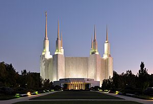
The Washington D.C. Temple is a famous building in South Kensington. It's known for its unique design and can be easily seen from the Capital Beltway. Traffic reports in the D.C. area often mention the "Mormon temple" when talking about this landmark.
Population Information
| Historical population | |||
|---|---|---|---|
| Census | Pop. | %± | |
| 1900 | 477 | — | |
| 1910 | 689 | 44.4% | |
| 1920 | 874 | 26.9% | |
| 1930 | 948 | 8.5% | |
| 1940 | 931 | −1.8% | |
| 1950 | 1,611 | 73.0% | |
| 1960 | 2,175 | 35.0% | |
| 1970 | 2,322 | 6.8% | |
| 1980 | 1,822 | −21.5% | |
| 1990 | 1,713 | −6.0% | |
| 2000 | 1,873 | 9.3% | |
| 2010 | 2,213 | 18.2% | |
| 2020 | 2,122 | −4.1% | |
| U.S. Decennial Census | |||
In 2010, there were 2,213 people living in Kensington. There were 870 households, and 563 families. The town had about 4,610 people per square mile (1,779 people per square kilometer).
About 82% of the people were White, 6.1% were African American, and 5.7% were Asian. About 6.4% of the population was Hispanic or Latino.
About 33.7% of households had children under 18 living with them. The average household had 2.54 people, and the average family had 3.17 people.
The average age of people in Kensington was 42.1 years. About 26.2% of residents were under 18, and 14.8% were 65 or older.
Local Businesses
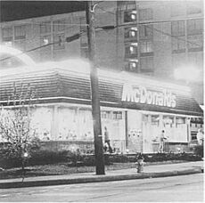
Kensington is mainly a "bedroom community." This means that many people who live here travel to work in the Washington, D.C., area. However, Kensington also has its own businesses.
You can find "Antique Row" on Howard Avenue, which is a popular spot for antique shops. There are also art shops, restaurants, supermarkets, auto repair shops, and hardware stores. The town has a website called Explore Kensington that lists local businesses, services, news, and events.
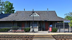
Kensington also hosts a farmers' market every Saturday. It's held from 9 a.m. to 1 p.m. at the train station.
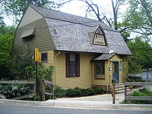
The town is home to the Noyes Library for Young Children. This is the oldest public library in Montgomery County.
Fun Events
- April 23 or the closest Sunday: The Kensington Day of the Book Festival is celebrated around World Book Day. This afternoon street festival has live music, authors reading their books, an open mic, and activities for kids and adults. Local authors, artists, publishers, and booksellers set up along Howard Avenue to share and sell their works. There's also a craft fair on Armory Avenue.
- Labor Day: Kensington has an annual Labor Day parade.
- Late September: The Kensington 8K Race has been held since 1994. It includes 8-kilometer, 2-mile, and 1-kilometer races. The races go through the historic part of town and along Beach Drive.
- Saturdays: Kensington parkrun is a free, timed 5K (about 3.1 miles) run or walk on the Rock Creek Trail.
Schools in Kensington
The schools in Kensington are part of the Montgomery County Public Schools system.
Schools serving the town of Kensington include:
- Kensington-Parkwood Elementary School
- North Bethesda Middle School
- Walter Johnson High School
Schools serving the larger Greater Kensington area include:
- Garrett Park Elementary School
- Kensington-Parkwood Elementary School
- Rosemary Hills Elementary School
- North Chevy Chase Elementary School
- Oakland Terrace Elementary School
- Rock View Elementary School
- Newport Mill Middle School
- North Bethesda Middle School
- Tilden Middle School
- Silver Creek Middle School
- Albert Einstein High School
- Bethesda-Chevy Chase High School
- Walter Johnson High School
Kensington is also home to several private schools:
- Spring Bilingual Montessori Academy
- Kensington Nursery School
- Holy Redeemer Catholic School (a Roman Catholic school)
- Grace Episcopal Day School
- Academy of the Holy Cross (an all-girls Roman Catholic high school)
Getting Around
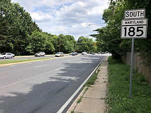
Four main state highways serve Kensington. The most important one is Maryland Route 185 (also known as Connecticut Avenue). This road connects Kensington directly to Interstate 495 (the Capital Beltway) and Washington, D.C..
Another major state highway is Maryland Route 193. This road follows University Boulevard and Greenbelt Road, going east from Kensington through the northern and northeastern suburbs of Washington. The other two state highways, Maryland Route 192 and Maryland Route 547, are shorter roads that link Kensington to nearby communities.
The MARC Brunswick Line has a stop at Kensington station. This train connects downtown Kensington to Washington, D.C., at Union Station. It also goes to places west of Kensington, like Point of Rocks, Maryland, and Harpers Ferry, West Virginia.
Kensington also has bus service from Ride On buses. Lines 4, 5, 33, 34, and 37 connect downtown Kensington to places like Silver Spring, Glenmont station, Medical Center station, and Wheaton.
Places to Worship
- Cedar Lane Unitarian Universalist Church
- Christ Episcopal Church
- First Baptist Church, Kengar
- Holy Redeemer Catholic Church
- Jehovah's Witnesses Kensington Kingdom Hall
- Kensington Baptist Church
- Lee Memorial AME Church
- Saint Paul's United Methodist Church
- Temple Emmanuel
- Warner Memorial Presbyterian Church
- Washington D.C. Temple of the Church of Jesus Christ of Latter-day Saints
- Kensington Ward of The Church of Jesus Christ of Latter-day Saints
See also
 In Spanish: Kensington (Maryland) para niños
 | Misty Copeland |
 | Raven Wilkinson |
 | Debra Austin |
 | Aesha Ash |


