
Chevy Chase View, Maryland facts for kids
Quick facts for kids
Chevy Chase View, Maryland
|
||
|---|---|---|
 |
||
|
||

Location of Chevy Chase View, Maryland
|
||
| Country | ||
| State | ||
| County | Montgomery | |
| Special Tax District | 1924 | |
| Incorporated | October 28, 1993 | |
| Area | ||
| • Total | 0.27 sq mi (0.69 km2) | |
| • Land | 0.27 sq mi (0.69 km2) | |
| • Water | 0.00 sq mi (0.00 km2) | |
| Elevation | 322 ft (98 m) | |
| Population
(2020)
|
||
| • Total | 1,005 | |
| • Density | 3,750.00/sq mi (1,446.46/km2) | |
| Time zone | UTC-5 (Eastern (EST)) | |
| • Summer (DST) | UTC-4 (EDT) | |
| ZIP code |
20895
|
|
| Area code(s) | 240 and 301 | |
| FIPS code | 24-16775 | |
| GNIS feature ID | 2390789 | |
Chevy Chase View is a small town located in Montgomery County, Maryland, in the United States. It's a quiet, friendly place where about 1,000 people live. The town officially became a special tax district in 1924 and then a full town on October 28, 1993.
Contents
How Chevy Chase View Began
The story of Chevy Chase View started on April 18, 1910. A map, called a "plat," was officially recorded for the area. A real estate developer named Claude Livingstone had designed the community the year before. He then transferred the land to Harry E. Smith and John L. Whitmore.
Livingstone's original design for the streets and layout has mostly stayed the same. In 1924, the area became a "special tax district." This meant residents paid taxes to help fund local services.
Later, on August 3, 1993, the Montgomery County Council voted. They decided to let the people living there vote on whether to become an official town. Residents voted "yes" in a special election on September 21, 1993. The county council then made it official on October 28, 1993. This made Chevy Chase View a fully incorporated town.
Where is Chevy Chase View?
Chevy Chase View is in the southern part of Montgomery County, Maryland. To its north, you'll find the town of Kensington. On all other sides, it's surrounded by an area called South Kensington.
The town is about 2 miles (3.2 km) north of other communities known as Chevy Chase. The United States Census Bureau says the town covers about 0.27 square miles (0.69 square kilometers) of land. There is no water area within the town limits.
A main road, Maryland Route 185 (Connecticut Avenue), cuts through the town. The Capital Beltway is about 1 mile (1.6 km) to the south. Nearby cities include Silver Spring (4 miles east), Garrett Park (2 miles northwest), and Bethesda (3 miles southwest). To the south, you'll find Rock Creek Stream Valley Park and North Chevy Chase.
Chevy Chase View is mostly a neighborhood with homes. There are only three places of worship inside its borders. The streets are lined with old oak, maple, and evergreen trees. The town also takes care of pretty plants along the roads. People tend to live here for a long time, so houses don't go up for sale very often.
Who Lives in Chevy Chase View?
| Historical population | |||
|---|---|---|---|
| Census | Pop. | %± | |
| 2000 | 863 | — | |
| 2010 | 920 | 6.6% | |
| 2020 | 1,005 | 9.2% | |
| U.S. Decennial Census | |||
In 2010, about 920 people lived in Chevy Chase View. There were 298 households, which are groups of people living together. Most of the people were White (94.3%). There were also African American (2.2%), Asian (2.0%), Native American (0.1%), and Pacific Islander (0.1%) residents. About 1.3% of people were from two or more races. Around 4.0% of the population was Hispanic or Latino.
Many households (42.3%) had children under 18 living with them. Most families (76.5%) were married couples. The average household had about 3 people, and the average family had about 3.4 people.
The average age of people in the town was 44.1 years old. About 32% of residents were under 18. Another 32% were between 45 and 64 years old. About 16% were 65 or older. The town had slightly more females (51.5%) than males (48.5%).
Schools in Chevy Chase View
Students living in Chevy Chase View go to schools in the Montgomery County Public Schools district.
Younger students attend Rosemary Hills Elementary School (PreK–2nd grade) and North Chevy Chase Elementary School (3rd–5th grade). Middle schoolers go to Silver Creek Middle School (6th–8th grade). For high school, students attend Bethesda-Chevy Chase High School (9th–12th grade).
Getting Around Town
The main state highway that goes through Chevy Chase View is Maryland Route 185, also known as Connecticut Avenue. This road connects to Interstate 495, which is a big highway called the Capital Beltway. This connection is just south of the town. MD 185 also provides a direct route to Washington, D.C..
Images for kids
-
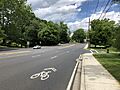
MD 185 northbound in Chevy Chase View
_just_south_of_Franklin_Street_in_Chevy_Chase_View,_Montgomery_County,_Maryland.jpg)
See also
 In Spanish: Chevy Chase View (Maryland) para niños
