
Georgetown (Washington, D.C.) facts for kids
Quick facts for kids
Georgetown
|
|
|---|---|
|
Neighborhood of Washington, D.C.
|
|
  .JPG)  .jpg) Top: Riggs Bank (left) and Georgetown University (right); Middle: Washington Harbour; Bottom: Wisconsin Avenue (left) and C&O Canal (right)
|
|
 |
|
| Country | United States |
| District | Washington, D.C. |
| Quadrant | Northwest |
| Ward | 2 |
Georgetown is a cool, old neighborhood in Washington, D.C.. It's located in the northwest part of the city, right next to the Potomac River. Georgetown was actually started in 1751, long before Washington, D.C. even existed! It was part of the Province of Maryland, a British colony back then.
For many years, Georgetown was its own town. But in 1871, the United States Congress decided to combine it with the rest of Washington, D.C. Later, in 1895, Georgetown's streets were even renamed to match the street names in D.C.
Today, Georgetown is famous for its busy shopping areas. You'll find lots of fancy shops, restaurants, and cafes along Wisconsin Avenue and M Street. There's also Washington Harbour on K Street, which has restaurants right by the water.
Georgetown is also home to Georgetown University, a well-known college. You can also visit the Old Stone House, which was built in 1765 and is the oldest building still standing in Washington, D.C. Another cool spot is the Chesapeake and Ohio Canal, a historic waterway. Many countries also have their embassies in Georgetown, like France and Sweden.
| Top - 0-9 A B C D E F G H I J K L M N O P Q R S T U V W X Y Z |
Discovering Georgetown's Past
Georgetown's location was very important because it was the farthest point up the Potomac River that boats could travel from the Atlantic Ocean. This made it a great place for trade.
Early Days: 17th and 18th Centuries
In 1632, an English fur trader named Henry Fleet found a Native American village called Tohoga where Georgetown is now. He started trading there. This area was then part of the Province of Maryland, an English colony.
Around 1745, a merchant named George Gordon built a tobacco inspection house by the Potomac River. This area was already a trading spot. Soon, warehouses and docks were built, and a small community grew. Georgetown became a busy port, helping to trade goods for the Maryland colony.
In 1751, Maryland's government bought 60 acres of land from Gordon and George Beall. The town was officially surveyed in 1752. Some people think Georgetown was named after King George II, while others believe it was named after its founders, George Gordon and George Beall. In 1789, the Maryland government officially recognized Georgetown as a town. Robert Peter, a tobacco merchant, became the town's first mayor in 1790.
Many churches were built in Georgetown during this time. The first was a Lutheran church, followed by a Presbyterian church in 1784, and a Catholic church in 1795. St. John's Episcopal Church started construction in 1797. Newspapers also began in Georgetown, with the Republican Weekly Ledger starting in 1790.
Famous taverns like City Tavern and Union Tavern opened in the 1790s. Only the City Tavern Club remains today, near Wisconsin Avenue and M Street. George Washington often visited Georgetown, including Suter's Tavern, where he made deals to buy land for the new capital city.
Georgetown in the 19th Century
In 1800, the U.S. capital moved from Philadelphia to Washington, D.C. Georgetown became one of three independent local governments within the new District of Columbia.
By the 1820s, the Potomac River near Georgetown became too shallow for large boats. So, in 1828, construction began on the Chesapeake & Ohio Canal. This canal was meant to connect Georgetown to places further west, like Harper's Ferry. However, it faced competition from the faster Baltimore and Ohio Railroad and was never very profitable.
Still, the canal helped Georgetown's economy. In the 1820s and 1830s, Georgetown was a big shipping hub. Goods like tobacco were moved between the canal and riverboats. Later, flour mills and other industries used the canal for cheap power. In 1862, a horsecar line started running along M Street, making it easier to travel between Georgetown and Washington.
In 1871, the U.S. Congress officially ended Georgetown's independent government. Its powers were given to the District of Columbia. In 1895, Georgetown's streets were renamed to match Washington's street system.
During the 1800s, many African Americans lived in Georgetown, both enslaved and free. Enslaved people were forced to work in building construction and on tobacco farms. Slave trading happened in Georgetown until it was banned in 1850. Slavery was completely ended in the entire District of Columbia on April 16, 1862, a day now celebrated as Emancipation Day. After the Civil War, many African Americans moved to Georgetown, creating a strong community.
One important place for the African American community is the Mount Zion United Methodist Church. It's the oldest African American church in Washington. Before this church, African Americans had to sit in a crowded balcony at another church. The Mount Zion Cemetery also offered free burials for African Americans.
By the late 1800s, industries like flour milling in Georgetown started to decline. The canals and waterways kept getting filled with dirt. A big flood in 1890 also hurt the C&O Canal. Georgetown's waterfront became more industrial, with many old homes preserved because the area wasn't developing quickly.
Georgetown in the 20th and 21st Centuries
.jpg)
.jpg)


In 1915, the Buffalo Bridge (on Q Street) opened, connecting Georgetown to the rest of the city. New apartment buildings started to appear. In the 1930s, people began to think about how to preserve Georgetown's historic look.
The Chesapeake and Ohio Canal stopped operating in 1924. After a big flood in 1936, the canal was sold to the National Park Service. The waterfront area remained industrial for a while, with lumber yards and mills. In 1949, the Whitehurst Freeway was built over K Street, allowing cars to bypass Georgetown.
In 1950, a law was passed to create the "Old Georgetown" historic district. This law means that any changes to buildings in this area must be approved to keep its historic feel. In 1967, the entire Georgetown neighborhood was listed on the U.S. National Register of Historic Places as a historic district.
Today, Georgetown is a popular place for politicians and people who work in government. The waterfront area was improved in 2003, adding hotels and more restaurants. Georgetown's shopping district is very popular, with many unique stores and boutiques.
Georgetown's Location and Features
Georgetown is bordered by the Potomac River to the south and Rock Creek to the east. To the north are neighborhoods like Burleith and Glover Park, and to the west is Georgetown University. Much of Georgetown is surrounded by parks and green spaces, like Rock Creek Park and Dumbarton Oaks. These areas help protect the neighborhood and offer places to relax.
The neighborhood is built on hills overlooking the Potomac River. This means some streets running north-south are quite steep! The famous "Exorcist steps" connect M Street to Prospect Street because of this hilly land.
The main shopping streets are M Street and Wisconsin Avenue. They have many fashion stores that attract tourists and local shoppers. The Washington Harbour complex on K Street has outdoor restaurants by the water, which are great for watching boat races. Between M and K Streets is the historic Chesapeake and Ohio Canal, where you can take tour boats or jog along the trails.
Learning in Georgetown
Schools for All Ages


Because many wealthy families lived in Georgetown, many private schools were built there over the years. One of the first was the Columbian Academy, started in 1781.
Today, private schools in Georgetown include Georgetown Visitation Preparatory School. Nearby is Georgetown Day School. Public schools in the area are run by District of Columbia Public Schools. These include Hyde-Addison Elementary School. For older students, there's Hardy Middle School and Jackson-Reed High School. The Duke Ellington School of the Arts, a public magnet school, is also in Georgetown.
Georgetown University: A Historic College

The main campus of Georgetown University is on the western edge of the Georgetown neighborhood. It was founded in 1789 by Father John Carroll as a Jesuit private university. Even though it had financial struggles early on, it grew into a large university after the American Civil War. As of 2007, it had thousands of undergraduate and graduate students.
The campus is over 102 acres and has 58 buildings. Many buildings are in a collegiate Gothic or Georgian brick style. The campus has green areas, fountains, and gardens. Healy Hall, built from 1877 to 1879, is a beautiful building and a National Historic Landmark.
The movie The Exorcist (1973) was partly filmed at Georgetown University. The famous "Exorcist steps" are a stairway connecting Prospect Street (near the campus) and M Street.
Public Libraries for Everyone
The District of Columbia Public Library has the Georgetown Neighborhood Library. It first opened in 1935. An earlier public library was started in Georgetown in 1867.
The current library building was badly damaged by a fire in 2007. It was renovated and expanded, reopening in 2010. It's now a modern building with a special third floor for researching Georgetown's history.
Getting Around Georgetown


Georgetown's location near the fall line of the Potomac River made it important for transportation. The Potomac Aqueduct Bridge (and later the Key Bridge) connected Georgetown to Virginia. Before bridges, a ferry service connected Georgetown to Virginia. In 1788, a bridge was built over Rock Creek to connect M Street with the Federal City.
Georgetown was also where the Alexandria Canal and the Chesapeake and Ohio Canal met. The C&O Canal started in Georgetown in 1829 and operated until 1924. Wisconsin Avenue follows an old road used for rolling tobacco barrels. The oldest bridge in the city, which carries Wisconsin Avenue over the C&O Canal, was built in 1831 and restored in 2007.
In the past, streetcars and interurban railways connected Georgetown to other areas. These lines ended in 1962. A railroad line also connected Silver Spring, Maryland, to Georgetown, mainly for shipping coal until 1985. This old railroad path is now the Capital Crescent Trail, a popular trail for walking and biking.
No Metro Station?
There isn't a Metro subway station in Georgetown. Some people didn't want one, but also, building a subway tunnel there would be very difficult because of the steep hills near the Potomac River. The Metro was planned mostly for commuters, and Georgetown doesn't have many large office buildings or apartments.
Even without a Metro station, you can still get to Georgetown easily. Three Metro stations are about a mile away: Rosslyn (across the Key Bridge in Virginia), Foggy Bottom-GWU, and Dupont Circle. Georgetown is also served by several Metrobuses and the DC Circulator bus. You can also use scooters from companies like Bird and Lime to get around.
Historic Places in Georgetown
|
Georgetown Historic District
|
|
| Location | Roughly bounded by Whitehaven Street, Rock Creek Park, the Potomac River, and the Georgetown University campus |
|---|---|
| Area | 750 acres (300 ha) |
| NRHP reference No. | 67000025 |
| Significant dates | |
| Added to NRHP | May 28, 1967 |
| Designated NHLD | May 28, 1967 |
The entire Georgetown neighborhood is a special place called the Georgetown Historic District. It was given this title in 1967 because it has so many well-preserved buildings from the colonial and Federal periods.
Georgetown is also home to several other important historic landmarks:
- The City Tavern Club, built in 1796, is the oldest commercial building in Washington, D.C.
- The Chesapeake and Ohio Canal, which started being built in 1829.
- Dumbarton Oaks, a historic estate where the United Nations charter was first discussed in 1944.
- The Forrest-Marbury House on M Street, where George Washington met with landowners to get land for Washington, D.C. It is now the Embassy of Ukraine.
- Georgetown Lutheran Church, founded in 1769, was the first church in Georgetown.
- Healy Hall at Georgetown University, built from 1877 to 1879, is a National Historic Landmark.
- Mount Zion United Methodist Church and Mount Zion Cemetery, important sites for African American history.
- The Oak Hill Cemetery, a beautiful cemetery with a Gothic Revival chapel.
- The Old Stone House, built in 1765 on M Street, is the oldest house in Washington, D.C.
- Tudor Place, another historic estate.
- The Volta Laboratory and Bureau, created by Alexander Graham Bell for research, especially to help deaf people.
Famous People Who Lived in Georgetown
Many interesting people have lived in Georgetown over the years:
- Francis Scott Key, who wrote "The Star-Spangled Banner" (the U.S. national anthem), lived in Georgetown in the early 1800s. He was inspired to write the song after witnessing the bombardment of Fort McHenry during the War of 1812.
- Alexander Graham Bell, who invented the telephone, moved to Georgetown because of his work and later created the Volta Laboratory and Bureau there.
- John F. Kennedy lived in Georgetown in the 1950s before he became president. He even proposed to Jackie at Martin's Tavern in Georgetown in 1953. He left his Georgetown home to go to his presidential inauguration in 1961.
- Herman Wouk, a writer who won the Pulitzer Prize, lived in Georgetown while writing his famous novels about World War II.
- Hollywood actress Elizabeth Taylor lived in Georgetown when she was married to Senator John Warner.
- Famous chef Julia Child lived in Georgetown in the 1940s and 1950s.
- Olivia Wilde, an actress, grew up in Georgetown.
- Former Secretary of State Madeleine Albright and John Kerry have lived in Georgetown.
- Bob Woodward, a famous reporter from the Washington Post, lives in Georgetown.
- Former FBI director Robert Mueller also lives in Georgetown.
Images for kids
-
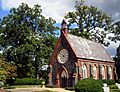
Oak Hill Cemetery Chapel, designed by James Renwick Jr. in 1850, is listed on the National Register of Historic Places.
-
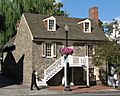
Old Stone House, built 1765, is the oldest building structure still standing in Washington, D.C.
-
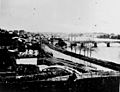
Georgetown, depicted in 1862, shows the Chesapeake and Ohio Canal and Aqueduct Bridge (on right) and an unfinished Capitol dome in the distant background.
-
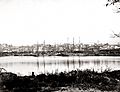
Sailing vessels docked at the Georgetown waterfront, c. 1865
-
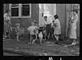
Children playing on sidewalk in Georgetown during the Great Depression, photographed by Carl Mydans in 1935
-
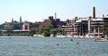
Washington Harbour complex located on the Potomac River with Georgetown University's Healy Hall visible in the background
-
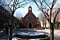
Dahlgren Chapel at Georgetown University
-
Martin's Tavern, where John F. Kennedy proposed to Jackie in 1953.


_fsa_8a00156_http-_hdl.loc.gov_loc.pnp_fsa.8a00156.jpg)


.jpg)
See also
 In Spanish: Georgetown (Washington D. C.) para niños
