
Alexandria Canal (Virginia) facts for kids
|
Alexandria Canal Tide Lock
|
|

Alexandria Canal Center with reconstructed Tidal Basin and Tidal Lock
|
|

Location in Alexandria Historical District

Location in Virginia

Location in the United States
|
|
| Nearest city | Alexandria, Virginia |
|---|---|
| Area | 5.7 acres (2.3 ha) |
| Built | 1833 |
| Architect | Alexandria Canal Co. |
| NRHP reference No. | 80004305 |
Quick facts for kids Significant dates |
|
| Added to NRHP | January 15, 1980 |
The Alexandria Canal was an important waterway in the United States. It connected the city of Alexandria to Georgetown in District of Columbia. This canal helped transport goods and people. It was a key part of trade in the 1800s.
Contents
Building the Canal
Why the Canal Was Needed
In 1830, business owners in Alexandria had a great idea. They wanted to connect their city to Georgetown. Georgetown was already linked to the new Chesapeake and Ohio Canal (C&O Canal). This new canal would help Alexandria's businesses grow. They could send and receive goods more easily.
Getting Started
The U.S. Congress agreed with the idea. They gave permission for the Alexandria Canal Company to be formed in 1830. This permission is called a charter. Building the canal began in 1833. It took ten years to finish, opening in 1843.
The Aqueduct Bridge
A special bridge was also built at the same time. This was the Aqueduct Bridge. It allowed canal boats from the C&O Canal to cross the Potomac River. They didn't have to go down to the river level. Instead, the boats stayed in the canal. They continued their journey on the southwest side of the Potomac. Their trip ended at Alexandria's seaport.
How the Canal Worked
The canal stretched about seven miles south. It went through what is now Arlington County and the City of Alexandria. Along its route, the canal dropped 38 feet in height. This change in height was managed by four special water elevators called locks. These locks were located between Washington Street and the Potomac River in Alexandria.
The canal ended at a place called the Tidal Basin. This was like a large pool. There was also a Tidal Lock, which was the first lock on the canal. These were located at the northern end of Old Town Alexandria.
What Happened to the Canal
Closing Down
The Alexandria Canal was used for many years. However, it was eventually closed in 1886. This was because new ways of transportation, like railroads, became more popular.
New Uses for the Canal Path
After the canal closed, its path was used for other things.
- In 1896, an electric trolley line was built. It followed the old towpath next to the canal in Arlington. This line was part of the Washington-Mount Vernon line. Today, South Eads Street in Arlington follows a similar route.
- Also in 1896, the Washington Southern Railway opened a new train line. It ran between the Long Bridge and the Aqueduct Bridge. This train line passed near The Pentagon. It followed the old canal path between Arlington National Cemetery and the Potomac River.
Modern Transportation
The train line changed names over the years. It was eventually closed in 1969. Later, the Washington Metropolitan Area Transit Authority built part of the Metrorail's Blue Line along this route. This section of the Blue Line opened on July 1, 1977.
What Remains Today
The original superstructure of the Aqueduct Bridge was removed in 1923. This happened after the Key Bridge was finished.
In the 1980s, archaeologists in Alexandria found parts of the old Tidal Basin and Lock. Developers then built a new version over the original remains. Today, you can see this reconstructed Tidal Basin and Lock. You can also see the ends of the Aqueduct Bridge in Georgetown and Rosslyn. One pier (support column) of the bridge is still in the Potomac River. Most other parts of the canal are either gone or buried underground.
Images for kids
-
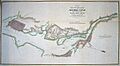
Map of the Alexandria Canal
-
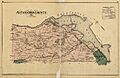
1878 map showing the Alexandria Canal route


. .
See Also
- Maps and aerial photos
- Aqueduct Bridge abutment, Georgetown: Hybrid satellite image/map from WikiMapia
- Aqueduct Bridge pier, Potomac River: Hybrid satellite image/street map from WikiMapia
- Aqueduct Bridge abutment, Rosslyn: Hybrid satellite image/street map from WikiMapia
- Metrorail Blue Line on former Alexandria Canal route, Arlington: Hybrid satellite image/street map from WikiMapia
- S. Eads Street on former Alexandria Canal route, Arlington: Hybrid satellite image/street map from WikiMapia
- Restored Tidal Basin and Lock of Alexandria Canal, Alexandria: Hybrid satellite image/street map from WikiMapia
