Point of Rocks station facts for kids
Quick facts for kids
Point of Rocks
|
||||||||||||||||||||
|---|---|---|---|---|---|---|---|---|---|---|---|---|---|---|---|---|---|---|---|---|
| MARC Commuter rail station | ||||||||||||||||||||

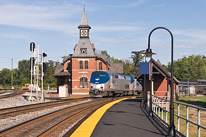
Amtrak's Capitol Limited passing through the Point of Rocks station.
|
||||||||||||||||||||
| Location | 4000 Clay Street, Point of Rocks, Maryland | |||||||||||||||||||
| Coordinates | 39°16′24.7″N 77°32′00″W / 39.273528°N 77.53333°W | |||||||||||||||||||
| Line(s) | Metropolitan Subdivision | |||||||||||||||||||
| Platforms | 2 side platforms | |||||||||||||||||||
| Tracks | 2 | |||||||||||||||||||
| Construction | ||||||||||||||||||||
| Parking | Yes | |||||||||||||||||||
| Disabled access | No | |||||||||||||||||||
| History | ||||||||||||||||||||
| Opened | 1873 | |||||||||||||||||||
| Traffic | ||||||||||||||||||||
| Passengers (2018) | 319 daily |
|||||||||||||||||||
| Services | ||||||||||||||||||||
|
||||||||||||||||||||
|
||||||||||||||||||||
|
Point of Rocks Railroad Station
|
||||||||||||||||||||
| Location | Off of U.S. 15 Point of Rocks, Maryland |
|||||||||||||||||||
| Area | 4 acres (1.6 ha) | |||||||||||||||||||
| Built | 1875 | |||||||||||||||||||
| Architect | Baldwin, E. Francis | |||||||||||||||||||
| Architectural style | Gothic | |||||||||||||||||||
| NRHP reference No. | 73000918 | |||||||||||||||||||
| Added to NRHP | April 11, 1973 | |||||||||||||||||||
Point of Rocks is a historic train station in Point of Rocks, Maryland. It's a stop on the MARC Brunswick Line, which connects Washington, D.C. to Martinsburg, West Virginia. This station is special because of its unique design and long history.
Contents
Station History and Design
The Point of Rocks station was built in 1873 by the Baltimore and Ohio Railroad. A famous architect named E. Francis Baldwin designed it. The station is located where two important train lines meet: the B&O Old Main Line, which goes to Baltimore, and the Metropolitan Branch, which goes to Washington, D.C.. The Metropolitan Branch opened in the same year, 1873. It quickly became the main route for passenger trains traveling between Baltimore, Washington, and places further west.
Architectural Style
The main station building is about two and a half stories tall. It has a triangular shape and is built in the Gothic Revival style. This style often includes pointed arches and tall windows, similar to old churches. The station also has a four-story tower with a pointed roof. On top of the tower is a smaller square structure called a cupola, also with a peaked roof.
Station Use Today
Even though it's a train station, the main building isn't open to the public. It's currently used by CSX, a large railroad company. They use it for storage and as offices for their maintenance crews. These crews help keep the train tracks in good condition.
In 2008, new platforms were built for people riding the MARC trains. These new platforms also have shelters to protect commuters from the weather. They replaced older, simpler shelters that were put up in the mid-1990s.
Blizzard Damage and Repair
In 2010, a big snowstorm hit the area. The heavy snow caused part of the station's roof, called an awning, to collapse. This left a section of the building without cover. However, work began in January 2011 to rebuild and fix the damaged part of the station.
National Recognition
The Point of Rocks Railroad Station is very important historically. Because of its unique design and history, it was added to the National Register of Historic Places in 1973. This listing helps protect important historical sites in the United States. After being listed, the station reopened for the Maryland Rail Commuter Service, which is now known as MARC.
 | Claudette Colvin |
 | Myrlie Evers-Williams |
 | Alberta Odell Jones |


