
Sugarloaf Mountain (Maryland) facts for kids
Quick facts for kids Sugarloaf Mountain |
|
|---|---|

Sugarloaf Mountain, sunset
|
|
| Highest point | |
| Elevation | 1,283 ft (391 m) |
| Geography | |
| Location | Frederick County, Maryland |
| Parent range | Blue Ridge Mountains (outlier) |
| Geology | |
| Age of rock | approx. 500 million years |
| Mountain type | Monadnock |
| Climbing | |
| Easiest route | Stairway and trail to summit |
| Designated: | June 1969 |
Sugarloaf Mountain is a beautiful mountain and park in Maryland. It stands about 10 miles (16 km) south of Frederick. The mountain is 1,283 feet (391 m) tall. It rises about 800 feet (244 m) above the farms around it. You can see it from many parts of northern Montgomery County and southern Frederick County. Because of its interesting geology and nature, it became a National Natural Landmark in 1969. It is a special park because it is privately owned but free for everyone to visit.
Contents
Exploring Sugarloaf Mountain's Past
Early Visitors and Discoveries
In 1712, a man named Christoph von Graffenried, 1st Baron of Bernberg visited the mountain. He came with his guide, Martin Chartier, and some Native Americans. The Baron wrote that they climbed the mountain, which looked like a "loaf of sugar." From the top, they could see a huge area. This included parts of Virginia, Maryland, Pennsylvania, and Carolina. They even used a compass to make a map!
Sugarloaf Mountain During the Civil War
During the American Civil War in 1862, soldiers used Sugarloaf Mountain. Union forces were on the summit. They used it as a lookout and signal station. On September 5, they saw the Confederate Army crossing the Potomac River into Maryland. The next morning, a small group of Union soldiers started to leave the mountain. They met some Confederate soldiers and a small fight happened. The Union soldiers got away, but were later caught.
Gordon Strong's Vision for the Mountain
In the early 1900s, a businessman named Gordon Strong bought a lot of land on and around the mountain. In 1925, a famous architect named Frank Lloyd Wright suggested building a special car-friendly area on top. This idea was never built.
Later, President Franklin D. Roosevelt thought about using Sugarloaf as his private retreat. But Gordon Strong convinced him to choose a different spot. That place, on Catoctin Mountain, is now known as Camp David.
In 1947, Gordon Strong created a special fund. This fund helps take care of the trails and other visitor areas at Sugarloaf Mountain. The mountain is still open to the public. It is owned by Stronghold, Incorporated.
What is Sugarloaf Mountain Made Of?

Sugarloaf Mountain is a type of mountain called a monadnock. This means it's a single hill or small mountain that rises suddenly from flat land. It's like an island in a sea of flat ground. Scientists think it might be a part of the ancient Appalachian mountains.
The mountain's rock is called Sugarloaf Mountain Quartzite. This rock is about 500 million years old! It's mostly a strong white rock called quartzite. It also has softer rocks like slate and phyllite mixed in.
Visiting Sugarloaf Mountain Today
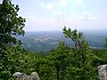
Sugarloaf Mountain is a popular place to visit. There is no fee to enter, but visitors are asked to donate $5. You can enjoy many activities here. These include hiking, rock climbing, and picnicking. Many people also come to see the amazing views from the top.
The mountain has a great system of trails. The blue trails are popular for hikers. The yellow trails can also be used by bikers and people riding horses at certain times. At the base of the mountain is the Strong Mansion. This beautiful building is often used for weddings and other special events. Nearby, the Sugarloaf Mountain Vineyard is also a fun place to visit.
Images for kids
-
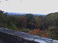
The scenic overlook at Sugarloaf Mountain
-
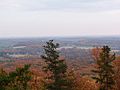
View at the top during fall
-
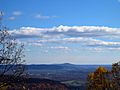
Sugarloaf Mountain as seen from Maryland Heights
-
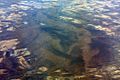
Oblique air photo of Sugarloaf Mountain, facing southwest, January 2009
-
The base of the mountain, as seen from the top.


