
The Carolinas facts for kids
Quick facts for kids
The Carolinas
|
|
|---|---|
|
Region
|
|
 |
|
| Country | |
| States | |
| Principal cities | - Charleston, South Carolina - Charlotte, North Carolina - Columbia, South Carolina - Greensboro, North Carolina - Greenville, South Carolina - Raleigh, North Carolina - Winston-Salem, North Carolina |
| Colonized as Province of Carolina |
1663 |
| Area | |
| • Total | 85,839 sq mi (222,320 km2) |
| • Land | 78,804 sq mi (204,100 km2) |
| • Water | 7,025 sq mi (18,190 km2) 8.2% |
| Population
(2015)
|
|
| • Total | 14,938,948 |
| • Density | 174.0345/sq mi (67.1951/km2) |
| Demonym(s) | Carolinian |
| Time zone | UTC-5 (EST) |
| • Summer (DST) | UTC-4 (EDT) |
The Carolinas are two states in the United States: North Carolina and South Carolina. People often talk about them together as one region. Both states were part of the original Thirteen Colonies that became independent from the British Empire. This happened after the American Revolutionary War, which ended in 1783.
During the time when they were colonies, the southern part of the Carolinas was important for trade with the British West Indies. Many people were brought there to work on large farms. The northern part of the region was not as crowded. It was mostly settled by people who had finished their work contracts in other areas, and they often started small tobacco farms.
Contents
What Makes the Carolinas Special?
The Carolinas are known for their diverse landscapes. You can find beautiful beaches along the Atlantic coast. Moving inland, there are flat plains and rolling hills. Further west, the Appalachian Mountains rise, offering stunning views and cooler temperatures.
How Big Are the Carolinas?
Together, North Carolina and South Carolina cover a large area. They stretch over 85,839 square miles (about 222,322 square kilometers). Most of this land is dry land, but a good portion is also covered by water, like rivers and lakes.
What is the Population of the Carolinas?
As of 2015, over 14.9 million people lived in the Carolinas. This makes it a very populated region in the United States. People who live in the Carolinas are sometimes called Carolinians.
Major Cities in the Carolinas
The Carolinas have several important cities. These cities are centers for business, culture, and education.
- Charlotte, North Carolina is the largest city in the Carolinas. It is a major financial hub.
- Raleigh, North Carolina is the capital city of North Carolina.
- Columbia, South Carolina is the capital city of South Carolina.
- Charleston, South Carolina is a historic city known for its beautiful architecture and coastal charm.
- Other important cities include Greensboro, North Carolina, Greenville, South Carolina, and Winston-Salem, North Carolina.
History of the Carolinas
The history of the Carolinas is long and interesting. It includes periods of Native American life, European colonization, and the formation of the United States.
How Did the Carolinas Get Their Name?
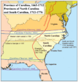
The region was named "Carolina" in honor of King Charles I of England. The name comes from "Carolus," which is Latin for Charles. It was first called the Province of Carolina in 1663.
Becoming Two Separate States
Over time, the large Province of Carolina became difficult to govern. The northern and southern parts developed differently. Because of these differences, the Province of Carolina officially split into North Carolina and South Carolina in 1712. They became separate royal colonies in 1729.
The Carolinas and the American Revolution
Both North and South Carolina played important roles in the American Revolutionary War. Many battles were fought in the region. People from the Carolinas helped the colonies gain their freedom from British rule.
Images for kids
-
The 1663 Province of Carolina Charter
-
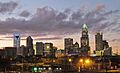
Charlotte skyline in 2011, the largest city and metro area of the Carolinas.


See also
 In Spanish: Las Carolinas para niños
