Washington County, Maryland facts for kids
Quick facts for kids
Washington County
|
|||
|---|---|---|---|
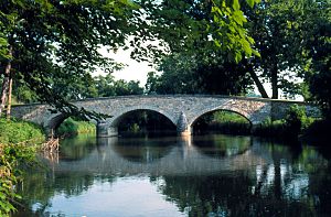
Burnside's Bridge in Washington County, site of heavy combat during the Battle of Antietam
|
|||
|
|||
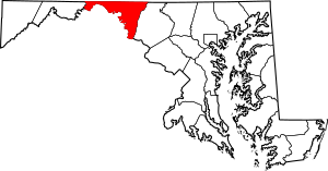
Location within the U.S. state of Maryland
|
|||
 Maryland's location within the U.S. |
|||
| Country | |||
| State | |||
| Founded | September 6, 1776 | ||
| Named for | George Washington | ||
| Seat | Hagerstown | ||
| Largest city | Hagerstown | ||
| Area | |||
| • Total | 467 sq mi (1,210 km2) | ||
| • Land | 458 sq mi (1,190 km2) | ||
| • Water | 9.6 sq mi (25 km2) 2.0% | ||
| Population
(2020)
|
|||
| • Total | 154,705 | ||
| • Estimate
(2023)
|
155,813 |
||
| • Density | 331.3/sq mi (127.91/km2) | ||
| Time zone | UTC−5 (Eastern) | ||
| • Summer (DST) | UTC−4 (EDT) | ||
| Congressional district | 6th | ||
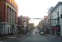
Washington County is a county in Maryland, a state in the United States. About 154,705 people lived here in 2020. The main city and county seat is Hagerstown. This county is part of the Western Maryland area.
Washington County was the first county in the U.S. to be named after George Washington. He was a general in the American Revolutionary War and later became the first President. The county is also part of Appalachia, a mountain region. It shares borders with Pennsylvania to the north, Virginia to the south, and West Virginia to the south and west.
Contents
History of Washington County
The western parts of what is now Washington County were once part of Prince George's County. This was back in 1696, when Maryland was still a colony. Prince George's County was very large, covering six future counties.
Later, in 1748, Frederick County was created from Prince George's County. Then, after the United States became independent, Washington County was officially formed. This happened on September 6, 1776. It was created by dividing Frederick County.
At first, Washington County included all of western Maryland. But over time, other counties were formed from its land. These included Allegany County in 1789 and Garrett County in 1872. Many historic places in Washington County are listed on the National Register of Historic Places.
Geography and Natural Features
Washington County covers about 467 square miles. Most of this area, 458 square miles, is land. The rest, about 9.6 square miles, is water.
The county is located in the Appalachian Mountains. In the west, you'll find the Ridge-and-Valley Appalachians. To the east is South Mountain, which is part of the Blue Ridge Mountains. Much of the county sits in the wide Hagerstown Valley. This valley is part of the larger Great Appalachian Valley.
The county's northern border is the Mason–Dixon line with Pennsylvania. To the south, the Potomac River separates it from Virginia and West Virginia. Sideling Hill Creek and Allegany County, Maryland are to the west. Frederick County and South Mountain are to the east.
Neighboring Counties
- Fulton County, Pennsylvania (north)
- Franklin County, Pennsylvania (north)
- Frederick County (east)
- Loudoun County, Virginia (southeast)
- Jefferson County, West Virginia (south)
- Berkeley County, West Virginia (south)
- Morgan County, West Virginia (southwest)
- Allegany County (west)
Main Roads and Highways
 Interstate 68
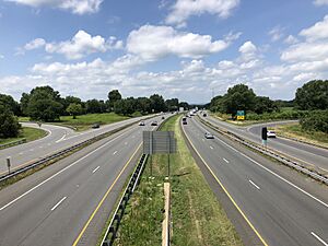
 Interstate 70
 Interstate 81
 U.S. Route 11
 U.S. Route 40
 U.S. Route 40 Alternate
 US 40 Scenic
 U.S. Route 340
 U.S. Route 522
 Maryland Route 34
 Maryland Route 56
 Maryland Route 57
 Maryland Route 58
 Maryland Route 60
 Maryland Route 62
 Maryland Route 63
 Maryland Route 64
 Maryland Route 65
 Maryland Route 66
 Maryland Route 67
 Maryland Route 68
 Maryland Route 77
 Maryland Route 144
 Maryland Route 180
 Maryland Route 418
 Maryland Route 491
 Maryland Route 494
 Maryland Route 550
 Maryland Route 615
 Maryland Route 632
People and Population
| Historical population | |||
|---|---|---|---|
| Census | Pop. | %± | |
| 1790 | 15,822 | — | |
| 1800 | 18,650 | 17.9% | |
| 1810 | 18,730 | 0.4% | |
| 1820 | 23,075 | 23.2% | |
| 1830 | 25,268 | 9.5% | |
| 1840 | 28,850 | 14.2% | |
| 1850 | 30,848 | 6.9% | |
| 1860 | 31,417 | 1.8% | |
| 1870 | 34,712 | 10.5% | |
| 1880 | 38,561 | 11.1% | |
| 1890 | 39,782 | 3.2% | |
| 1900 | 45,133 | 13.5% | |
| 1910 | 49,617 | 9.9% | |
| 1920 | 59,694 | 20.3% | |
| 1930 | 65,882 | 10.4% | |
| 1940 | 68,838 | 4.5% | |
| 1950 | 78,886 | 14.6% | |
| 1960 | 91,219 | 15.6% | |
| 1970 | 103,829 | 13.8% | |
| 1980 | 113,086 | 8.9% | |
| 1990 | 121,393 | 7.3% | |
| 2000 | 131,923 | 8.7% | |
| 2010 | 147,430 | 11.8% | |
| 2020 | 154,705 | 4.9% | |
| 2023 (est.) | 155,813 | 5.7% | |
| U.S. Decennial Census 1790-1960 1900-1990 1990-2000 2010–2018 |
|||
In 2010, there were 147,430 people living in Washington County. There were 55,687 households. Most people (85.1%) were white. About 9.6% were Black or African American. People of Hispanic or Latino origin made up 3.5% of the population.
The average age in the county was about 39.7 years old. Many households (32.4%) had children under 18 living with them. The average household had 2.50 people.
Cities and Towns
City
- Hagerstown (This is the county seat, where the main government offices are.)
Towns
Census-Designated Places (CDPs)
These are areas that look like towns but don't have their own local government.
- Antietam
- Bagtown
- Bakersville
- Beaver Creek
- Big Pool
- Big Spring
- Breathedsville
- Brownsville
- Cavetown
- Cearfoss
- Charlton
- Chewsville
- Dargan
- Downsville
- Eakles Mill
- Edgemont
- Ernstville
- Fairplay
- Fairview
- Fort Ritchie
- Fountainhead-Orchard Hills
- Gapland
- Garretts Mill
- Greensburg
- Halfway
- Highfield-Cascade
- Indian Springs
- Jugtown
- Kemps Mill
- Leitersburg
- Mapleville
- Maugansville
- Mercersville
- Middleburg
- Mount Aetna
- Mount Briar
- Mount Lena
- Paramount-Long Meadow
- Pecktonville
- Pinesburg
- Pondsville
- Reid
- Ringgold
- Robinwood
- Rohrersville
- Saint James
- San Mar
- Sandy Hook
- Tilghmanton
- Trego-Rohrersville Station
- Wilson-Conococheague
- Yarrowsburg
Unincorporated Communities
These are places that are not part of a city or town.
Economy and Jobs
Washington County has many different types of jobs. Some of the largest employers include hospitals, banks, and big companies that handle shipping and logistics.
Here are some of the major employers in the county:
| Employer | Employees (Nov. 2014) |
|---|---|
| Meritus Health | 2,730 |
| Citi | 2,700 |
| First Data | 2,322 |
| Volvo Group | 1,350 |
| The Bowman Group | 718 |
| FedEx Ground | 648 |
| Staples Inc. | 597 |
| Hagerstown Community College | 594 |
| Merkle Response Management Group | 545 |
| Arc of Washington County | 500 |
| Direct Mail Processors | 500 |
| Walmart/Sam's Club | 500 |
| Sierra Nevada Corp. | 486 |
| Giant Food Stores/ Martin's Food Markets |
420 |
| Weis Markets | 400 |
| Brook Lane Health Services | 395 |
| Lehigh Phoenix | 360 |
| A.C.&T | 350 |
| Susquehanna Bancshares | 345 |
| Dot Foods | 312 |
| JLG Industries | 300 |
| Home Depot | 296 |
| Lowe's | 276 |
| Thompson's Gas & Electric Service | 275 |
| United Parcel Service (UPS) | 274 |
| CertainTeed | 250 |
| Darden Restaurants | 250 |
| Sheetz | 250 |
| Tractor Supply | 250 |
| Homewood Retirement Centers | 249 |
| NMS Healthcare of Hagerstown | 240 |
| Horizon Goodwill Industries | 229 |
| C. William Hetzer | 225 |
| FedEx Freight | 225 |
The county is also a top producer of fruits, tree nuts, and berries in Maryland.
Parks and Fun Places
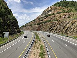
Washington County has many great places to visit for outdoor fun and history.
National Parks and Trails
- Antietam National Battlefield: A famous Civil War battle site.
- Appalachian National Scenic Trail: A long hiking trail that passes through the county.
- Chesapeake and Ohio Canal National Historical Park: A historic canal with trails for walking and biking.
- Harpers Ferry National Historical Park: A historic town at the meeting of two rivers.
State Parks
- Fort Frederick State Park
- Fort Tonoloway State Park
- Gathland State Park
- Greenbrier State Park
- South Mountain State Park
- Washington Monument State Park
Museums and Historic Sites
- Bowman House, Boonsboro
- Crystal Grottoes: Maryland's only show caves.
- Discovery Station, Hagerstown
- Hager House, Hagerstown
- Hagerstown Roundhouse Museum, Hagerstown
- Price-Miller House, Hagerstown
- Sideling Hill: A man-made mountain pass on Interstate 68/U.S. Route 40. It shows millions of years of rock layers.
- Springfield Farm, Williamsport
- Stoney Creek Farm, Boonsboro
- Washington County Museum of Fine Arts, Hagerstown
- Washington County Rural Heritage Museum, Boonsboro
Schools and Learning
Washington County Public Schools runs the public schools in the county. You can find many elementary, middle, and high schools here.
High Schools
|
Public High Schools
|
Private High Schools
|
Colleges and Universities
- Antietam Bible College, Biblical Seminary, and Graduate School
- Hagerstown Community College: A two-year public college.
- Kaplan College (formerly Hagerstown Business College)
- Mount Saint Mary's University, Hagerstown Campus: Offers a Master of Business Administration (MBA) program.
- University System of Maryland at Hagerstown: A branch of the University System of Maryland. It offers many different degree programs.
Famous People from Washington County
- You can find a list of notable people from this area at People from Washington County.
See also
 In Spanish: Condado de Washington (Maryland) para niños
 | William L. Dawson |
 | W. E. B. Du Bois |
 | Harry Belafonte |


