
Berkeley County, West Virginia facts for kids
Quick facts for kids
Berkeley County
|
||
|---|---|---|
|
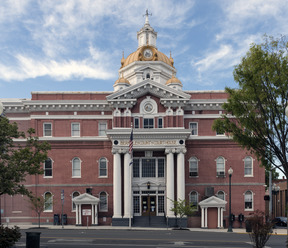
Berkeley County Courthouse
Adam Stephen House
Hedgesville Historic District
Sleepy Creek Wildlife Management Area
|
||
|
||

Location of Berkeley County in West Virginia
|
||

West Virginia's location within the U.S.
|
||
| Country | ||
| State | ||
| Founded | May 15, 1772 | |
| Seat | Martinsburg | |
| and largest city | ||
| Area | ||
| • Total | 832.8 km2 (321.56 sq mi) | |
| • Land | 831.8 km2 (321.15 sq mi) | |
| • Water | 1.1 km2 (0.41 sq mi) 0.5% | |
| Area rank | 40th | |
| Population
(2020)
|
||
| • Total | 122,076 | |
| • Estimate
(2021)
|
126,069 |
|
| • Rank | 2nd | |
| • Density | 146.77/km2 (380.12/sq mi) | |
| Time zone | UTC−5 (Eastern) | |
| • Summer (DST) | UTC−4 (EDT) | |
| Area code(s) | 304, 681 | |
| Congressional district | 2nd | |
| Senate districts | 15th, 16th | |
| House of Delegates districts | 90th-97th | |
| Website | http://www.berkeleywv.org/ | |


Berkeley County is a place in the Shenandoah Valley of West Virginia, in the United States. It's part of a larger area called the Hagerstown–Martinsburg metropolitan area. In 2020, about 122,076 people lived here, making it the second most populated county in West Virginia. The main city and county center is Martinsburg.
Contents
History of Berkeley County
Berkeley County was created on May 15, 1772. This happened when the House of Burgesses (an early government group) took the northern part of Frederick County to form it. At that time, it was still part of Virginia. Later, in 1863, during the Civil War, West Virginia became its own state. Berkeley County was the second oldest county in the new state.
When Berkeley County was first formed, it included areas that are now Jefferson and Morgan counties in West Virginia.
Most historians believe the county was named after Norborne Berkeley, Baron de Botetourt (1718–1770). He was the Colonial Governor of Virginia from 1768 to 1770. He tried to help the colonists by asking the British Parliament to remove some taxes. When they refused, he asked to leave his job. The colonists respected him and even built a monument for him. Two counties were named in his honor: Berkeley in West Virginia and Botetourt in Virginia.
Some other historians think the county might have been named after Sir William Berkeley (1610–1677). He was also a Governor of Virginia, serving from 1642 to 1652 and again from 1660.
Early Settlers and Native Americans
Long ago, in the late 1500s and early 1600s, thousands of Hurons lived in what is now West Virginia, including the eastern panhandle. Later, the Iroquois Confederacy (a group of powerful Native American tribes) moved the Hurons out. The Iroquois used the area mainly for hunting.
In the early 1700s, the Tuscarora lived in the eastern panhandle. They later moved north to New York and joined the Iroquois Confederacy. Other tribes like the Shawnee, Mingo, and Delaware also used this area for hunting.
After the French and Indian War, many Native American tribes still saw the British as a threat. In 1763, Pontiac, an Ottawa chief, led attacks on British forts. Shawnee chief Cornstalk also led attacks on settlements in western Virginia, including areas near Berkeley Springs. These attacks ended when British forces defeated the Delaware and Shawnee tribes.
During the American Revolutionary War (1775–1783), the Mingo and Shawnee tribes sided with the British. They attacked Fort Henry near Wheeling. These attacks made it difficult for European settlers to move into West Virginia. After the war, the Mingo and Shawnee moved further west as more settlers arrived.
European Explorers Arrive
In 1670, John Lederer, a German doctor and explorer, was the first European to explore what is now Berkeley County. A few years later, John Howard and his son also explored the area.
The next known explorer was John Van Meter in the 1730s. He explored the Potomac River and the South Branch Potomac River. In 1726, Morgan Morgan moved from Delaware and started the first lasting English settlement in West Virginia. This was near Bunker Hill in Berkeley County. West Virginia has a monument and a marker at Morgan's grave to remember this important event. His son, Zackquill Morgan, later founded Morgantown.
In 1748, George Washington, who was only sixteen years old, surveyed the land in present-day Berkeley County. He later visited the warm springs in Bath (Berkeley Springs), West Virginia several times with his half-brother, who hoped the springs would help his health.
The 1800s and the Civil War
Berkeley County became smaller twice in the 1800s. In 1801, Jefferson County was formed from its eastern part. Then, in 1820, Morgan County was created from its western part.
Berkeley County was very important during the American Civil War (1861–1865). The county and its main city, Martinsburg, were at the northern edge of the Shenandoah Valley. Martinsburg was important because the main Baltimore and Ohio Railroad line ran through it. This railroad was vital for moving soldiers and supplies for both sides. Martinsburg changed hands many times during the war, especially before the Battle of Gettysburg in 1863. After Gettysburg, the Union Army mostly controlled the city.
About 75% of Berkeley County's residents supported the Southern side during the Civil War. Many soldiers from the county joined the Southern (Confederate) Army. There were at least eleven groups of soldiers from the county: nine for the Confederate Army and two for the Union Army.
One famous person from Berkeley County was Maria Isabella "Belle" Boyd, who was a spy for the Confederacy.
Joining West Virginia
During the Civil War, Berkeley and Jefferson counties decided to join the new state of West Virginia. This happened in 1863. Many voters who were fighting in the Confederate Army did not agree with this decision when they returned home. Virginia tried to get the counties back through a lawsuit. However, in 1871, the U.S. Supreme Court decided that West Virginia could keep Berkeley and Jefferson counties.
In 1863, West Virginia divided its counties into smaller areas called townships to help with local government. This didn't work well in rural areas, so in 1872, they changed them to "magisterial districts." Berkeley County first had seven districts. Later, between 1990 and 2000, it was redivided into six new districts.
Geography

Berkeley County covers about 322 square miles. Most of this is land, with a small amount of water.
Mountains and Hills
- Third Hill Mountain – This is the highest peak in the county.
- Sleepy Creek Mountain
- North Mountain
Rivers and Streams
- Potomac River
- Back Creek
- Tilhance Creek
- Cherry Run
- Meadow Branch
- Opequon Creek
- Middle Creek
- Mill Creek
- Tuscarora Creek
Major Highways
_in_Nollville,_Berkeley_County,_West_Virginia.jpg)
 I‑81
I‑81 US 11
US 11 WV 9
WV 9 WV 45
WV 45 WV 51
WV 51 WV 115
 WV 901
Neighboring Counties
- Washington County, Maryland (north)
- Jefferson County (southeast)
- Frederick County, Virginia (south)
- Morgan County (northwest)
People of Berkeley County (Demographics)
| Historical population | |||
|---|---|---|---|
| Census | Pop. | %± | |
| 1790 | 19,713 | — | |
| 1800 | 22,006 | 11.6% | |
| 1810 | 11,479 | −47.8% | |
| 1820 | 11,211 | −2.3% | |
| 1830 | 10,518 | −6.2% | |
| 1840 | 10,972 | 4.3% | |
| 1850 | 11,771 | 7.3% | |
| 1860 | 12,525 | 6.4% | |
| 1870 | 14,900 | 19.0% | |
| 1880 | 17,380 | 16.6% | |
| 1890 | 18,702 | 7.6% | |
| 1900 | 19,469 | 4.1% | |
| 1910 | 21,999 | 13.0% | |
| 1920 | 24,554 | 11.6% | |
| 1930 | 28,030 | 14.2% | |
| 1940 | 29,016 | 3.5% | |
| 1950 | 30,359 | 4.6% | |
| 1960 | 33,791 | 11.3% | |
| 1970 | 36,356 | 7.6% | |
| 1980 | 46,846 | 28.9% | |
| 1990 | 59,253 | 26.5% | |
| 2000 | 75,905 | 28.1% | |
| 2010 | 104,169 | 37.2% | |
| 2020 | 122,076 | 17.2% | |
| 2022 (est.) | 129,490 | 24.3% | |
| U.S. Decennial Census 1790–1960 1900–1990 1990–2000 2010–2020 |
|||
2020 Census Information
In 2020, there were 122,076 people living in Berkeley County. Most people (80.5%) were White. About 7.7% were African American, and 1.2% were Asian. People of Hispanic or Latino background made up 5.6% of the population. The average age in the county was 38.5 years old. About 22.9% of the people were under 18.
2010 Census Information
In 2010, there were 104,169 people living in the county. About 87.8% were white, and 7.1% were black or African American. About 3.8% of the people were of Hispanic or Latino origin. The average age was 37.6 years.
Communities
City
- Martinsburg (This is the county seat, meaning it's the main center for county government.)
Town
Census-designated places
Unincorporated communities
- Allensville
- Arden
- Baker Heights
- Baxter
- Bedington
- Berkeley
- Bessemer
- Blairton
- Bunker Hill
- Darkesville
- Douglas Grove
- Files Crossroad
- Ganotown
- Georgetown
- Gerrardstown
- Glengary
- Greensburg
- Grubbs Corner
- Hainesville
- Johnsontown
- Jones Springs
- Little Georgetown
- Marlowe
- Nipetown
- Nollville
- North Mountain
- Pikeside
- Ridgeway
- Scrabble
- Shanghai
- Spring Mills
- Swan Pond
- Tablers Station
- Tarico Heights
- Tomahawk
- Union Corner
- Van Clevesville
- Vanville
- Winebrenners Crossroad
- Wynkoop Spring
Magisterial Districts
- Adam Stephen
- Norborne
- Potomac
- Shenandoah
- Tuscarora
- Valley
Notable People
- Victoria "Vicky" Bullett – A former professional women's basketball player. She won gold and bronze medals in the Olympics.
- Christopher Martinka – An award-winning photographer.
- Thomas Hinds (1780–1840) – A military hero from the War of 1812 and a US Congressman.
- William Robinson Leigh (1866–1955) – An American artist known for his Western scenes.
- Christian Lopez (born 1995) – An American singer-songwriter.
See also
 In Spanish: Condado de Berkeley (Virginia Occidental) para niños
