
Berkeley Springs, West Virginia facts for kids
Quick facts for kids
Berkeley Springs, West Virginia
|
||
|---|---|---|
| Town of Bath | ||

Town square in Berkeley Springs
|
||
|
||
| Motto(s):
"America's First Spa"
|
||
_Highlighted.svg)
Location of Bath (Berkeley Springs) in Morgan County, West Virginia.
|
||
| Country | United States | |
| State | West Virginia | |
| County | Morgan | |
| Incorporation | December 1776 | |
| Government | ||
| • Type | Mayor–council | |
| Area | ||
| • Total | 0.34 sq mi (0.87 km2) | |
| • Land | 0.34 sq mi (0.87 km2) | |
| • Water | 0.00 sq mi (0.00 km2) | |
| Elevation | 656 ft (200 m) | |
| Population
(2020)
|
||
| • Total | 758 | |
| • Estimate
(2021)
|
755 | |
| • Density | 1,773.81/sq mi (685.65/km2) | |
| Time zone | UTC−5 (Eastern (EST)) | |
| • Summer (DST) | UTC−4 (EDT) | |
| ZIP Code |
25411
|
|
| Area code(s) | 304 | |
| FIPS code | 54-04876 | |
| GNIS feature ID | 1877535 | |
| Website | townofbath.org/government | |

Berkeley Springs is a town in West Virginia, United States. It's often called by its postal name, Berkeley Springs. The town's official name is actually Bath. It is the main town in Morgan County, West Virginia.
This area is famous for its natural mineral springs. Native Americans used these springs for possibly thousands of years. Later, many European settlers came to visit. Famous people like George Washington and James Rumsey visited the springs long ago.
Berkeley Springs has been a popular resort spot for a long time. It hosts the Berkeley Springs International Water Tasting, which is the biggest and oldest event of its kind in the world. Another fun event is the Apple Butter Festival, which started in 1974. Today, tourism is very important here. There are six spas in the area that use the mineral water.
Contents
History of Berkeley Springs

In 1748, when George Washington was just 16, he helped survey this area. He came back many times with his sick half-brother, Lawrence. They hoped the warm springs would help him get better. The springs and their healing stories attracted many Native Americans and Europeans.
By 1767, Washington noticed how busy the town had become. Lord Fairfax, a wealthy landowner, had built a summer home and a private bath there. This made the area a popular place for important people from Virginia. In December 1776, a law was passed to create a town at the Warm Springs. The town was officially named Bath, after the famous spa city Bath in England.

George Washington and his family were among the first people to own land in the new town. The main streets were named Washington and Fairfax. Four acres of land were set aside for public use, known as The Grove. This area, with its springs and bathhouses, later became Berkeley Springs State Park in 1925. Nearby, Cacapon State Park opened in 1933.
The town of Bath grew quickly during and after the Revolutionary War. Many wounded soldiers and others came, believing the warm springs had special healing powers.
How the Town Got Its Name
In 1772, the springs became part of a new area called Berkeley County. The springs were then known as Berkeley Springs. This was because it was common to name springs after the county they were in. Before this, the area was called Warm Springs or Medicinal Springs.
In 1802, the Virginia postal system was set up. There was already another town called Bath in Virginia. So, to avoid confusion, the town became known as Berkeley Springs for its post office.
During the American Civil War in 1861, many people in Virginia did not want to leave the United States. West Virginia became a separate state in 1863. Berkeley Springs remained the common name for the town. It even has a sister city named Bath in England.
Where is Berkeley Springs?
Berkeley Springs is located in the Appalachian Mountains in the eastern part of West Virginia. It is about 26 miles (42 km) northwest of Martinsburg, West Virginia and 36 miles (58 km) west of Hagerstown, Maryland. Berkeley Springs is the main town in Morgan County.
The town of Bath covers about 0.34 square miles (0.88 km2) of land.
Morgan County has two rivers. The Potomac River forms the northern border. The Cacapon River flows through the middle of the county and joins the Potomac. Cacapon Mountain and Sleepy Creek Mountain are the two most important mountains in the county. Berkeley Springs sits at an elevation of about 656 feet (200 m). A small stream called Warm Spring Run flows through the town and eventually reaches the Potomac River.
People in Berkeley Springs
In 2020, the population of Berkeley Springs (the town of Bath) was 758 people.
Getting Around Berkeley Springs
_between_Market_Street_and_Warren_Street_in_Berkeley_Springs_(Bath),_Morgan_County,_West_Virginia.jpg)
Two main highways serve Berkeley Springs. U.S. Route 522 runs north and south. To the north, it connects to major highways like Interstate 70 and Interstate 68 near Hancock, Maryland. To the south, it connects to Interstate 81 near Winchester, Virginia.
The other main road is West Virginia Route 9. It runs northwest to southeast. WV 9 goes west to Paw Paw and east to Martinsburg. Both highways share a short section of Main Street in Berkeley Springs.
Famous People from Berkeley Springs
- Beirne Lay, Jr., a U.S. Army pilot.
- Tom Netherton, a singer from the Lawrence Welk Show.
- Charles Triplett O'Ferrall, a politician.
- John Herbert Quick, an author.
- James Rumsey, an early inventor of the steamboat.
- David Hunter Strother, a journalist, artist, and diplomat.
- Lajos Veress, a Hungarian military officer.
Images for kids
-
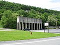
Storage bins no longer in use. They were once used by a local sand mine.
-
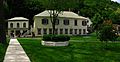
A view of part of Berkeley Springs State Park.
-
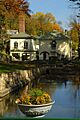
Another view of Berkeley Springs State Park, showing fall colors.
-
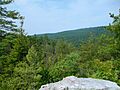
A view of Sleepy Creek Mountain from Devil's Nose.
-
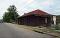
The former train station.


See also
 In Spanish: Bath (Virginia Occidental) para niños
