
Morgan County, West Virginia facts for kids
Quick facts for kids
Morgan County
|
||
|---|---|---|

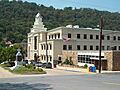
Morgan County Courthouse Complex, July 2011
|
||
|
||

Location within the U.S. state of West Virginia
|
||
 West Virginia's location within the U.S. |
||
| Country | ||
| State | ||
| Founded | February 9, 1820 | |
| Named for | Daniel Morgan | |
| Seat | Berkeley Springs | |
| Largest town | Berkeley Springs | |
| Area | ||
| • Total | 230 sq mi (600 km2) | |
| • Land | 229 sq mi (590 km2) | |
| • Water | 0.5 sq mi (1 km2) 0.2%% | |
| Population
(2020)
|
||
| • Total | 17,063 | |
| • Estimate
(2021)
|
17,221 |
|
| • Density | 74.2/sq mi (28.6/km2) | |
| Time zone | UTC−5 (Eastern) | |
| • Summer (DST) | UTC−4 (EDT) | |
| Congressional district | 2nd | |

Morgan County is a county in the U.S. state of West Virginia. In 2020, about 17,063 people lived here. Its main town, or county seat, is Berkeley Springs.
The county was created in 1820 from parts of Hampshire and Berkeley Counties. It was named after General Daniel Morgan, a brave soldier from the American Revolutionary War.
Morgan County is a great place for tourists. It has many local artists, relaxing mineral water spas, and lots of outdoor fun. You can enjoy fishing, boating, wildlife watching, hunting, and beautiful mountain views. The area is also famous for its Apple Butter Festival, held every October. Plus, Morgan County is home to an important silica mine.
Contents
History of Morgan County
Morgan County was officially formed in February 1820. This happened when the Virginia General Assembly decided to create it from parts of Berkeley and Hampshire counties.
The county got its name from General Daniel Morgan (1736–1802). He was born in New Jersey and later moved to Virginia. Daniel Morgan was a wagon driver in the army during a campaign against Native Americans in 1755. Once, a British officer hit him with a sword, and Morgan punched him back. For this, he was sentenced to 500 lashes. Morgan later joked that the person counting the lashes made a mistake, and he only got 499. He would say the British still owed him one!
Early Settlers and Famous Visitors
The first English settlers arrived in what is now Morgan County in the 1730s. Many of these early pioneers didn't officially record their names. Historians believe the first cabin was built around 1745.
News of the county's warm springs spread. In 1748, Thomas Fairfax, 6th Lord Fairfax of Cameron decided the area needed to be surveyed. A young George Washington, who was only 16 at the time, was part of the team that surveyed this region. He later came back to Bath (Berkeley Springs) several times. His half-brother, Lawrence, was sick, and they hoped the warm springs would help him feel better. Both Native Americans and Europeans were drawn to the springs because of their rumored healing powers.
How Bath Became Berkeley Springs
George Washington visited the area many times. In 1767, he noticed how popular the town had become. Lord Fairfax had built a summer home and a private bath there. This made it a favorite spot for important people from Virginia.
In October 1776, the Virginia General Assembly officially named the town Bath. This was in honor of Bath, a famous spa city in England. The main streets were named Washington and Fairfax. Seven acres of land were also set aside for "suffering humanity." When West Virginia became a state, this area became its first state park.
After the American Revolutionary War, more people came to Bath. Wounded soldiers and others believed the warm springs had healing qualities. Bath became known as a lively town with lots of eating, drinking, dancing, and horse racing.
Later, Bath became known as Berkeley Springs. This happened mainly because the town's post office took the name Berkeley Springs. This helped avoid confusion with another town in Virginia already called Bath. The name Berkeley Springs slowly became the most common name for the town.
Morgan County in the 19th Century
Morgan County was one of the fifty counties from Virginia that joined the Union to form the state of West Virginia. This happened on June 20, 1863. Later that year, counties were divided into smaller areas called civil townships to help with local government. This didn't work well in rural West Virginia. So, in 1872, the townships became magisterial districts. Morgan County had six districts: Allen, Bath, Cacapon, Rock Gap, Sleepy Creek, and Timber Ridge. These districts stayed mostly the same until the 1980s. Then, they were combined into three new districts: District 1, District 2, and District 3. A District 4 was added in the 1990s but later removed.
Morgan County in the 20th Century
In 1919, there was a difficult situation in Morgan County. Some local businesses used African-American workers during a strike by white workers. On April 10, 1919, a man named Hugh Ferguson was accused of a crime. A large crowd gathered around the jail, hoping to harm him. The Sheriff, C. R. Hovermale, had to take Ferguson out of town to keep him safe.
Geography of Morgan County
Morgan County covers about 230 square miles. Most of this area, about 229 square miles, is land. Only a small part, about 0.5 square miles, is water.
Main Roads
 U.S. Highway 522
 West Virginia Route 9
Neighboring Counties
- Washington County, Maryland (north)
- Berkeley County (east)
- Frederick County, Virginia (southeast)
- Hampshire County (southwest)
- Allegany County, Maryland (northwest)
Rivers and Streams
Population and People
| Historical population | |||
|---|---|---|---|
| Census | Pop. | %± | |
| 1820 | 2,500 | — | |
| 1830 | 2,694 | 7.8% | |
| 1840 | 4,253 | 57.9% | |
| 1850 | 3,557 | −16.4% | |
| 1860 | 3,732 | 4.9% | |
| 1870 | 4,315 | 15.6% | |
| 1880 | 5,777 | 33.9% | |
| 1890 | 6,744 | 16.7% | |
| 1900 | 7,294 | 8.2% | |
| 1910 | 7,848 | 7.6% | |
| 1920 | 8,357 | 6.5% | |
| 1930 | 8,406 | 0.6% | |
| 1940 | 8,743 | 4.0% | |
| 1950 | 8,276 | −5.3% | |
| 1960 | 8,376 | 1.2% | |
| 1970 | 8,547 | 2.0% | |
| 1980 | 10,711 | 25.3% | |
| 1990 | 12,128 | 13.2% | |
| 2000 | 14,943 | 23.2% | |
| 2010 | 17,541 | 17.4% | |
| 2020 | 17,063 | −2.7% | |
| 2021 (est.) | 17,221 | −1.8% | |
| U.S. Decennial Census 1790–1960 1900–1990 1990–2000 2010–2020 |
|||
What the 2020 Census Shows
In 2020, there were 17,063 people living in Morgan County. Most residents, about 93.7%, were White. About 0.7% were African American, and 0.5% were Asian. People of Hispanic or Latino background made up 1.4% of the population.
The average age in the county was 48.5 years. About 17.7% of the people were under 18 years old. The average income for a household was $56,616. About 8% of the population lived below the poverty line.
Communities in Morgan County

Towns
- Berkeley Springs (This is the county seat, where the main government offices are.)
- Paw Paw
Magisterial Districts
These are areas used for local government.
Current Districts
- District 1
- District 2
- District 3
Historic Districts
- Allen
- Bath
- Cacapon
- Rock Gap
- Sleepy Creek
- Timber Ridge
- District 4 (no longer used)
Census-Designated Places
Other Communities
- Berryville
- Burnt Factory
- Campbells
- Cherry Run
- Doe Gully
- Duckwall
- Green Ridge
- Greenwood
- Hancock (used to be called Brosius)
- Hansrote
- Holton
- Jerome
- Jimtown
- Johnsons Mill
- Largent
- Lineburg
- Magnolia
- Mount Trimble
- New Hope
- North Berkeley
- Oakland
- Omps
- Orleans Cross Roads
- Redrock Crossing
- Ridersville
- Ridge
- Rock Gap
- Sir Johns Run
- Sleepy Creek
- Smith Crossroads
- Spohrs Crossroads
- Stotlers Crossroads
- Unger
- Woodmont
- Woodrow
Historic Places to Visit
Many places in Morgan County are listed on the National Register of Historic Places. This means they are important historical sites.
- Ambrose Chapel: A historic church from the mid-1800s.
- Berkeley Springs State Park: This park has the famous warm springs and dates back to the mid-1700s. It's West Virginia's first state park!
- Berkeley Springs Train Depot: A train station built in 1915.
- Chesapeake and Ohio Canal National Historical Park: Part of a historic canal system from the early 1800s.
- Clarence Hovermale House: Also known as Allen Mendenhall House, built in the late 1800s.
- John Herbert Quick House: Known as Coolfont Manor House, built in 1913.
- Judge John W. Wright Cottage: A charming cottage built in 1872.
- New Deal Resources in Cacapon State Park Historic District: Features buildings from 1934 within Cacapon State Park.
- Morgan County Courthouse: The main government building, built in 1923.
- Samuel Taylor Suit Cottage: Also called Berkeley Castle, a grand home built in 1885.
- Sloat-Horn-Rossell House: Known as The Manor, built in the late 1800s.
- T. H. B. Dawson House: A historic house built in 1880.
- Town of Bath Historic District: The historic center of Berkeley Springs, dating from 1776 to 1959.
- Paw Paw Old Mayor's Office and Jail: Built in 1893 in Paw Paw.
- Saint Charles Catholic Mission Church: A church built in 1876 in Paw Paw.
- Paw Paw Black School: A historic school built in 1928 in Paw Paw.
- Sen P. E. Nixon House: A house built in 1909.
- Western Maryland Railroad Right-of-Way, Milepost 126 to Milepost 160: A section of historic railroad from the 20th century.
Images for kids
-
Morgan County Courthouse Complex, July 2011
See also
 In Spanish: Condado de Morgan (Virginia Occidental) para niños
