Stotlers Crossroads, West Virginia facts for kids
Quick facts for kids
Stotlers Crossroads
|
|
|---|---|

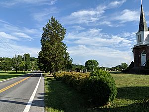
Mount Olivet Church and cemetery along Winchester Grade Road through Stotlers Crossroads
|
|
| Country | United States |
| State | West Virginia |
| County | Morgan |
| Elevation | 728 ft (222 m) |
| Time zone | UTC-5 (Eastern (EST)) |
| • Summer (DST) | UTC-4 (EDT) |
| GNIS feature ID | 1555723 |
Stotlers Crossroads is a small, quiet community in southeastern Morgan County, West Virginia. It is called an "unincorporated community" because it doesn't have its own local government like a city or town. Think of it as a small group of homes and buildings that are part of the larger county.
This little place is found along Winchester Grade Road (which is also known as County Route 13). It sits between two parts of Sleepy Creek, called the South Fork and Middle Fork. The community is also located on the eastern side of a hill called Highland Ridge, which is about 942 feet tall.
What's in a Name?
This community got its name from a person named W. R. Stotler. He was a merchant, which means he owned a store or business. His store was located right where several roads met, creating a "crossroads." So, people started calling the area "Stotlers Crossroads" after him.
Historic Buildings
Stotlers Crossroads is home to some interesting old buildings. One of these is the Mount Olivet United Methodist Church, which was built in 1888. Imagine how many years that church has been standing!
Another important building is Ambrose Chapel. Both the Mount Olivet Church and Ambrose Chapel are listed on the National Register of Historic Places. This is a special list kept by the United States government. It includes places, buildings, and objects that are important to the history of the country. Being on this list helps protect these historic sites.
Getting Around
Stotlers Crossroads is a place where several roads come together. Winchester Grade Road (CR 13) meets up with Virginia Line Road and Highland Ridge Road (CR 8) here. This makes it a central spot for travel in the local area.
 | Frances Mary Albrier |
 | Whitney Young |
 | Muhammad Ali |


