Pen Mar, Maryland facts for kids
Quick facts for kids
Pen Mar, Maryland
|
|
|---|---|
| Country | United States |
| State | Maryland and Pennsylvania |
| County | Washington and Franklin |
| Elevation | 1,322 ft (403 m) |
| Time zone | UTC-5 (Eastern (EST)) |
| • Summer (DST) | UTC-4 (EDT) |
| ZIP code |
21719
|
| Area code(s) | 301 |
| FIPS code | 24-043 |
| GNIS feature ID | 590993 |
Pen Mar is a small place located right on the border between Maryland and Pennsylvania in the United States. It's called an "unincorporated community," which means it's not a city or town with its own local government. Pen Mar is special because its name, "Pen Mar," is a mix of "Pennsylvania" and "Maryland"!
This area became famous in the late 1800s and early 1900s as a fun resort. Today, Pen Mar is known as the northern starting point for the Maryland section of the famous Appalachian Trail.
Contents
A Fun Resort in the Mountains

The Pen Mar area became popular in the late 1800s. A special resort was built there in 1877. Colonel John Mifflin Hood thought that a resort in the Blue Ridge Mountains would make people want to ride his trains. These trains belonged to the Western Maryland Railway.
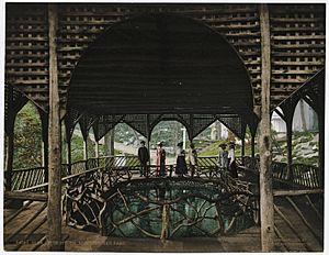
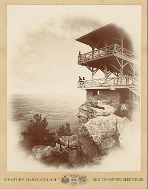
The Western Maryland Railway didn't just build a resort. They also created an amusement park! This park had many cool things to do. There was a scenic lookout with amazing views. It also had a roller coaster, a movie theater, and a dance hall. You could find picnic areas, a miniature train, and a photo studio. There were also places to buy snacks, a carousel with arcade games, a dining hall, and a playground for kids.
The Park's Big Success
The park was a huge hit! Thousands of visitors traveled 71 miles from Baltimore to Pen Mar. On some days, nearly 20,000 people visited the park. It was a very popular place for families and friends to have fun.
The Town of Pen Mar
As the park grew, so did the village of Pen Mar. The town of Pen Mar was officially recognized in 1920. During this time, the town had its own post office. There were also many hotels and over 100 boarding houses for visitors. However, the official recognition of the town was removed just two years later, in 1922.
The Park's Decline and New Life
By the end of the 1920s, the park started to lose its popularity. Fewer people were traveling there by train. By 1929, the park was no longer making money for the Western Maryland Railway. The park was then rented out to a private owner. This person managed to keep the park open until 1943.
When the park closed, the surrounding area also became less important. The Pen Mar post office closed in the 1960s. The area slowly became smaller and less well-known in Maryland.
In 1953, people in Pen Mar wanted the old resort site to become a state park. Pen Mar was planned to be a state park in 1963–64. But for reasons we don't know, it never became a Maryland state park. Instead, the park was sold to Washington County, Maryland. It was then turned into a county park, which opened in 1977. Since then, new things have been added, like a scenic overlook and a pavilion for events.
Geography
Pen Mar is located at 39°43′4″N 77°30′22″W / 39.71778°N 77.50611°W.
Pen Mar is found on the border of Maryland and Pennsylvania. It sits on South Mountain. The village is about 1,322 feet (403 meters) above sea level. From this high spot, you can see beautiful views of the mountains and valleys around it.
South of Pen Mar Park is a place called High Rock. This is a popular spot within South Mountain State Park. It's close to the Appalachian Trail and has a great overlook. People also use High Rock as a place to launch hang gliders!
See also
 In Spanish: Pen Mar (Pensilvania) para niños
 | Emma Amos |
 | Edward Mitchell Bannister |
 | Larry D. Alexander |
 | Ernie Barnes |


