Woodsboro, Maryland facts for kids
Quick facts for kids
Woodsboro, Maryland
|
|||
|---|---|---|---|
| Town of Woodsboro | |||
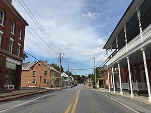
Main Street in Woodsboro
|
|||
|
|||
| Motto(s):
"Small Town Life at its Best!"
|
|||
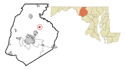
Location of Woodsboro, Maryland
|
|||
| Country | |||
| State | |||
| County | |||
| Founded | 1786 | ||
| Incorporated | 1836 | ||
| Area | |||
| • Total | 0.71 sq mi (1.84 km2) | ||
| • Land | 0.71 sq mi (1.83 km2) | ||
| • Water | 0.00 sq mi (0.01 km2) | ||
| Elevation | 345 ft (105 m) | ||
| Population
(2020)
|
|||
| • Total | 1,092 | ||
| • Density | 1,544.55/sq mi (595.97/km2) | ||
| Time zone | UTC-5 (Eastern (EST)) | ||
| • Summer (DST) | UTC-4 (EDT) | ||
| ZIP code |
21798
|
||
| Area code(s) | 301, 240 | ||
| FIPS code | 24-86750 | ||
| GNIS feature ID | 2391492 | ||
| Website | Woodsboro On-Line | ||
Woodsboro is a small town located in Frederick County, Maryland, in the United States. It was first given to Joseph Wood way back in 1693. In 2020, about 1,092 people lived there.
Contents
Woodsboro's Past: A Look at History
The town of Woodsboro gets its name from Joseph Wood, who received the land in 1693. Over the years, some important places in Woodsboro have been recognized for their historical value. For example, the LeGore Bridge was added to the National Register of Historic Places in 1978. Later, in 2007, Woods Mill Farm also joined this list.
Rosebud Perfume Company's Story
In 1895, a doctor named George F. Smith started the Rosebud Perfume Company in Woodsboro. Dr. Smith had eight children and was also the mayor of the town for 19 years! His business stayed in the family for generations.
Even in 2012, the company was still making its famous "Smith's Rosebud Salve." This product started as a special lip gloss and salve called tholene. While the company's main office is in Woodsboro, the salve itself is made and put into tins in other Maryland towns like Joppa and Baltimore.
Historic Buildings in Woodsboro
Woodsboro has several buildings that people have thought about protecting because of their history. These include the Woodsboro Savings Bank and some buildings connected to the three limestone quarries that used to operate near the town.
Where is Woodsboro? Geography and Location
Woodsboro covers a total area of about 0.71 square miles (1.84 square kilometers). According to the United States Census Bureau, all of this area is land.
Getting Around: Transportation in Woodsboro
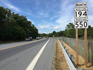
The main way to travel to and from Woodsboro is by road. Two important state highways serve the town:
- Maryland Route 194 runs from the northeast to the southwest. It connects Woodsboro to the Frederick area and Taneytown.
- Maryland Route 550 goes from the northwest to the southeast. This road links Woodsboro to places like Thurmont and Libertytown.
For a short distance on the northeast side of Woodsboro, both of these roads follow the same path.
Who Lives in Woodsboro? Demographics
| Historical population | |||
|---|---|---|---|
| Census | Pop. | %± | |
| 1880 | 336 | — | |
| 1910 | 362 | — | |
| 1920 | 385 | 6.4% | |
| 1930 | 385 | 0.0% | |
| 1940 | 416 | 8.1% | |
| 1950 | 427 | 2.6% | |
| 1960 | 430 | 0.7% | |
| 1970 | 439 | 2.1% | |
| 1980 | 506 | 15.3% | |
| 1990 | 513 | 1.4% | |
| 2000 | 846 | 64.9% | |
| 2010 | 1,141 | 34.9% | |
| 2020 | 1,092 | −4.3% | |
| U.S. Decennial Census | |||
Woodsboro's Population in 2010
Based on the census from 2010, there were 1,141 people living in Woodsboro. These people made up 423 households, with 306 of them being families. The town had about 1,607 people per square mile (620 people per square kilometer). There were 443 homes, with about 624 homes per square mile (241 homes per square kilometer).
Most of the people in Woodsboro were White (91.9%). Other groups included African American (3.7%), Asian (1.3%), and Native American (0.1%). About 1.1% of residents were from other races, and 1.9% were from two or more races. People of Hispanic or Latino background made up 4.0% of the population.
About 38.1% of households had children under 18 living with them. Most households (60.5%) were married couples living together. The average household had 2.70 people, and the average family had 3.23 people.
The average age of people in Woodsboro was 41.1 years. About 27% of residents were under 18 years old. About 12.1% of the population was 65 years old or older. Slightly more than half of the town's residents (53.4%) were female, and 46.6% were male.
See also
 In Spanish: Woodsboro (Maryland) para niños


