
Howard County, Maryland facts for kids
Quick facts for kids
Howard County
|
|||
|---|---|---|---|
 .jpg)   .jpg)  Clockwise: Main Street in Ellicott City, Merriweather Post Pavilion in Columbia, McKeldin Rapids in Patapsco Valley State Park, Howard County Conservatory, Savage Mill, Town Center in Columbia.
|
|||
|
|||
| Nickname(s):
"HoCo"
|
|||

Location within the U.S. state of Maryland
|
|||
 Maryland's location within the U.S. |
|||
| Country | |||
| State | |||
| Founded | May 13, 1838 | ||
| Named for | John Eager Howard | ||
| Seat | Ellicott City | ||
| Largest community | Columbia | ||
| Area | |||
| • Total | 253 sq mi (660 km2) | ||
| • Land | 251 sq mi (650 km2) | ||
| • Water | 2.7 sq mi (7 km2) 1.0% | ||
| Population
(2020)
|
|||
| • Total | 328,200 | ||
| • Density | 1,297.2/sq mi (500.9/km2) | ||
| Time zone | UTC−5 (Eastern) | ||
| • Summer (DST) | UTC−4 (EDT) | ||
| Congressional districts | 3rd | ||


Howard County is a county in the state of Maryland, United States. It is often called "HoCo" for short. As of 2020, about 334,529 people live there.
Howard County does not have any official cities or towns. So, its main government center, called the county seat, is the community of Ellicott City. The county is part of the larger Washington–Baltimore combined statistical area. This means it is close to both Washington, D.C. and Baltimore.
Many people know Howard County for its high quality of life and excellent schools. It is one of the wealthiest counties in the U.S. In 2020, the average household income was around $124,042.
The communities of Columbia and Ellicott City are often listed among the "Best Places to Live" by Money magazine. Howard County also ranks high in the nation for education. About 63.6% of adults aged 25 and over have a college degree or higher. In 2022, the Howard County Public School System was named the best school district in Maryland.
Contents
- Why is it Called Howard County?
- Howard County's Past
- Where is Howard County?
- People of Howard County
- Schools and Learning
- Working in Howard County
- Awards and Recognitions
- Famous People from Howard County
- Fun Things to Do and See
- Getting Around Howard County
- Communities in Howard County
- Images for kids
- See also
Why is it Called Howard County?

Howard County is named after Colonel John Eager Howard. He was an important officer in the "Maryland Line" during the American Revolutionary War. He was a brave leader in battles, including the Battle of Cowpens in 1781.
After the war, he became the fifth governor of Maryland. He served as governor from 1788 to 1791.
Howard County's Past

Before Europeans arrived in the 1600s, the land that is now Howard County was home to Indigenous peoples. These included the Piscataway and Susquehannock tribes. They used the area for farming and hunting. In 1652, the Susquehannock tribes signed a peace treaty. This agreement gave up their claim to the land that became Howard County.
In 1838, a man named Dr. William Watkins suggested creating the "Howard District." This district was part of Anne Arundel County. In 1839, the western part of Anne Arundel County officially became the Howard District. It was like a county but did not have its own representatives in the state government.
The first courthouse in Ellicott City was built in 1841. On July 4, 1851, the Howard District officially became Howard County. This happened after a new state constitution was approved.
Life in the 1800s
Some large farms in Howard County used slave labor as early as 1690. During the time of the Underground Railroad, some people in Howard County helped enslaved people escape to freedom. This was dangerous, as many wealthy families in the area supported the Southern states during the Civil War. Maryland ended slavery in November 1864.
In 1883, Howard County joined Anne Arundel and Harford counties in banning alcohol. By 1899, Howard County had many dirt roads and some stone roads. Most goods were transported by wagons to train stations.
Growth and Modernization
In 1918, a serious flu pandemic spread through the county. In the 1930s, schools changed from small, one-room buildings to larger, central schools with bus services.
In 1940, a plan began to build a major highway between Baltimore and Washington through Howard County. This led to the building of Interstate 70 and Interstate 95 in the 1950s. These highways helped the county grow.
New companies like W.R. Grace and Johns Hopkins Applied Physics Lab became big employers. People wanted to keep the county's rural feel, but planners expected many more residents by the year 2000.
From 1963 to 1966, a company called the Rouse Company bought a lot of land. They planned and built Columbia, a large, modern community. Many historic places in Howard County are listed on the National Register of Historic Places.
Where is Howard County?
Howard County covers about 253 square miles. Most of this is land (251 square miles), with a small amount of water (2.7 square miles). It is the second-smallest county in Maryland by land area.

The county is in the Piedmont Plateau region of Maryland. This area has rolling hills. The Patapsco River forms its northern border, and the Patuxent River forms its southwestern border. Both rivers flow through public parklands. The Patuxent River border includes the Triadelphia and Rocky Gorge reservoirs, which are large lakes.
Neighboring Counties
Howard County shares borders with these counties:
- Anne Arundel County (southeast)
- Baltimore County (northeast)
- Carroll County (north)
- Montgomery County (southwest)
- Prince George's County (south)
 |
Frederick County | Carroll County | Baltimore County, Baltimore |
|
| Montgomery County, Washington, D.C. |
Prince George's County | Anne Arundel County |
Weather in Howard County
Howard County has a humid subtropical climate. This means it has hot, humid summers and mild to cool winters. As you go west in the county, winter temperatures get a bit colder, and more snow falls. The county gets about 45 inches of rain each year.
People of Howard County
For a long time, Howard County was mostly rural and had a small population. In 1950, only about 23,000 people lived there. Since then, the population has grown more than tenfold. It has also become much more diverse.
By 2017, almost half of the people in Howard County were from non-white backgrounds. This change happened a lot after 1967. That's when The Rouse Company designed Columbia to be a community where people from different backgrounds could live together.
African-Americans have lived in Howard County for centuries. Their population grew a lot after the 1960s. Many people have also moved to Howard County from Asia, especially Korea, India, and China. People from Latin America have also moved there.
While the county was mostly Christian in the past, it now has many Jewish, Muslim, and Hindu residents. In 2019, about 18,700 Jewish people lived in the county.
| Historical population | |||
|---|---|---|---|
| Census | Pop. | %± | |
| 1860 | 13,338 | — | |
| 1870 | 14,150 | 6.1% | |
| 1880 | 16,140 | 14.1% | |
| 1890 | 16,269 | 0.8% | |
| 1900 | 16,715 | 2.7% | |
| 1910 | 16,106 | −3.6% | |
| 1920 | 15,826 | −1.7% | |
| 1930 | 16,169 | 2.2% | |
| 1940 | 17,175 | 6.2% | |
| 1950 | 23,119 | 34.6% | |
| 1960 | 36,152 | 56.4% | |
| 1970 | 61,911 | 71.3% | |
| 1980 | 118,572 | 91.5% | |
| 1990 | 187,328 | 58.0% | |
| 2000 | 247,842 | 32.3% | |
| 2010 | 287,085 | 15.8% | |
| 2020 | 328,200 | 14.3% | |
| 2023 (est.) | 336,001 | 17.0% | |
| U.S. Decennial Census 1790-1960 1900-1990 1990-2000 2010–2018 2010-2020 |
|||
Population in 2020
As of the 2020 United States census, Howard County had 328,200 people. The population density was about 1,300 people per square mile.
The racial and ethnic makeup of the county in 2020 was:
- White (not Hispanic): 46.71%
- Black or African American (not Hispanic): 19.26%
- Asian (not Hispanic): 19.88%
- Mixed Race (not Hispanic): 5.07%
- Hispanic or Latino (any race): 8.23%
- Other races (not Hispanic): 0.67%
- Native American or Alaska Native (not Hispanic): 0.14%
- Pacific Islander (not Hispanic): 0.03%
Population in 2010
In 2010, there were 287,085 people living in Howard County. The population density was about 1,145 people per square mile. The average household had 2.72 people.
The median income for a household was $103,273. For a family, it was $119,810. Only about 4.2% of the population lived below the poverty line.
Schools and Learning
The Howard County Public School System manages 71 schools. It serves about 49,000 students. In 2009, the graduation rate was 90.4%. The schools in Howard County are known as some of the best in Maryland. Students' test scores are consistently among the highest in the state. Reservoir High School is the largest school in the county.
Howard County Library System
In 2013, the Howard County Library System was named "Library of the Year" by Library Journal. It was praised as a great example of a modern library. In 2015, it was named the top "Star Library" in its group.
Working in Howard County
In July 2014, the unemployment rate in Howard County was 5.2 percent. This means about 7,527 people were looking for jobs.
The Howard County Public School System is a major employer, with over 8,000 staff members. The County Government also employs many people in roles like police, public works, and fire and rescue.
Top Private Employers
Here are some of the largest private employers in Howard County:
| # | Employer | # of Employees |
|---|---|---|
| 1 | Johns Hopkins University Applied Physics Laboratory | 8,000 |
| 2 | Verizon Wireless | 2,028 |
| 3 | Lorien Health Systems | 2,000 |
| 4 | Howard County General Hospital | 1,777 |
| 5 | Howard Community College | 1,294 |
| 6 | Leidos | 1,195 |
| 7 | Giant Food | 1,050 |
| 8 | The Columbia Association | 900 |
| 9 | Wells Fargo | 842 |
| 10 | Oracle Corporation subsidiary MICROS Systems | 815 |
Awards and Recognitions

Howard County and its communities have received many awards:
- "4th Richest County in America" by Forbes Magazine (2017).
- "Best Place to Live" by CNN/Money magazine. Columbia was #1 in 2016. Ellicott City/Columbia have been in the top 10 many times.
- "Best Places to Live for Pet Lovers" by CNN/Money (Ellicott City, 2009).
- "Best Place to Raise a Family" by Forbes (#17 in 2008).
- "Good Sports Community of the Year" by Sports Illustrated (2005).
- "Great Public Library System" by Hennen's American Public Library Ratings.
- "Healthiest Maryland County" by University of Wisconsin Population Health Institute (multiple years).
- "Library of the Year" by Library Journal (2013).
- "Tree City Community" by Arbor Day Foundation (for 23 years).
- Merriweather Post Pavilion was named a top outdoor concert venue by Pollstar and Rolling Stone.
Famous People from Howard County
- Edward Norton, actor
- Taylor Cummings, lacrosse player
- Toby Orenstein, theater director
- Yumi Hogan, politician
- Michael Campanaro, football wide receiver
- Kenneth Ulman, politician
- Ernie Pickett, weightlifter
- Charles Schnetzler, scientist
- Laura Lippman, author
- Lloyd Keaser, wrestler
- Nina Basu, president of the Inner Arbor Trust
- James B. Garvin, scientist
- Brent Faiyaz, singer and record producer
- K.A.A.N., rapper and songwriter
Fun Things to Do and See


Howard County has many attractions and cultural spots:
- Blandair, a large open space park
- Bollman Truss Railroad Bridge, a historic bridge
- The Candlelight Concert Society
- The Chesapeake Shakespeare Company
- Clark's Elioak Farm, a fun farm with animals and fairy tale attractions
- Columbia Center for Theatrical Arts
- The Columbia Orchestra
- Ellicott City Historic Main Street, a charming historic area
- Ellicott City Station, a historic train station
- The Enchanted Forest (some parts moved to Clark's Elioak Farm)
- Howard County Center for the Arts
- Howard County Library
- Horowitz Visual and Performing Arts Center
- Maryland's Koreatown
- Merriweather Post Pavilion, a popular outdoor concert venue
- Rep Stage
- James and Anne Robinson Nature Center
- Savage Mill, a historic mill with shops and restaurants
- Shrine of St. Anthony
- Toby's Dinner Theatre
Getting Around Howard County
Airports
Howard County does not have its own large public airports. There is one private airstrip called Glenair Airport in Glenelg. Most people use nearby major airports like Baltimore/Washington International Airport, Ronald Reagan Washington National Airport, and Washington Dulles International Airport.
Major Roads
_in_Columbia,_Howard_County,_Maryland.jpg)
Many important highways run through Howard County, making it easy to travel:
- Interstate 70
- Interstate 95
- Interstate 895
- U.S. Route 1
- U.S. Route 29
- U.S. Route 40
- Maryland Route 27
- Maryland Route 32
- Maryland Route 94
- Maryland Route 97
- Maryland Route 99
- Maryland Route 100
- Maryland Route 103
- Maryland Route 108
- Maryland Route 125
- Maryland Route 144
- Maryland Route 175
- Maryland Route 216
Communities in Howard County
Census-Designated Places
These are areas that the Census Bureau recognizes as distinct communities:
- Columbia
- Elkridge
- Ellicott City (the county seat)
- Fulton
- Highland
- Ilchester
- Jessup (partly in Anne Arundel County)
- North Laurel
- Savage
- Scaggsville
Other Communities
These are other well-known communities in the area that are not officially census-designated places:
- Clarksville
- Cooksville
- Daniels
- Dayton
- Dorsey
- Glenelg
- Glenwood
- Granite
- Guilford
- Hanover (partly in Anne Arundel County)
- Isaacsville
- Lisbon
- Marriottsville (partly in Carroll County and Baltimore County)
- Simpsonville
- West Friendship
- Woodbine
- Woodstock
Images for kids
-
Flag of Howard County, Maryland.
-
Seal of Howard County, Maryland.
-
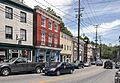
Main Street in Ellicott City.
-
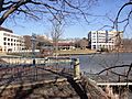
Town Center in Columbia.
-

Merriweather Post Pavilion in Columbia.
-
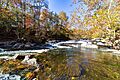
McKeldin Rapids in Patapsco Valley State Park.
-
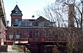
Savage Mill.
-

Howard County Conservatory.
See also
 In Spanish: Condado de Howard (Maryland) para niños
