Jessup, Maryland facts for kids
Quick facts for kids
Jessup, Maryland
|
|
|---|---|

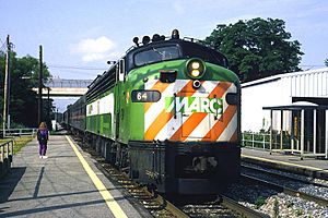
A MARC train at Jessup in June 1994
|
|

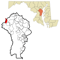
Location of Jessup, Maryland in Anne Arundel County
|
|
| Country | |
| State | |
| Counties | Anne Arundel Howard |
| Established | 1863 |
| Founded by | Jonathan Jessup |
| Area | |
| • Total | 6.05 sq mi (15.68 km2) |
| • Land | 6.05 sq mi (15.66 km2) |
| • Water | 0.01 sq mi (0.01 km2) |
| Elevation | 217 ft (66 m) |
| Population
(2020)
|
|
| • Total | 10,535 |
| • Density | 1,741.90/sq mi (672.56/km2) |
| Time zone | UTC−5 (Eastern (EST)) |
| • Summer (DST) | UTC−4 (EDT) |
| ZIP code |
20794
|
| Area code(s) | 240, 301, 410, 443 |
| FIPS code | 24-42550 |
| GNIS feature ID | 0590560 |
Jessup (pronounced JESS-up) is a community in Maryland, United States. It's not an official city, but a "census-designated place." This means it's an area that the government counts for population, but it doesn't have its own city government. Jessup is located in both Howard and Anne Arundel counties. It's about 15 miles (24 km) southwest of Baltimore. In 2020, about 10,535 people lived there.
Contents
Where is Jessup?
Jessup is located at coordinates 39.138374, -76.774929. The total area of Jessup is about 5.25 square miles (13.6 square kilometers), and it's all land. Interestingly, the geographic center of Maryland is located within Jessup, at the Clifton T. Perkins Hospital Center.
A Look Back: Jessup's History
Jessup is close to where a famous old place called Spurrier's Tavern used to be. This tavern was on a main road between Baltimore and Washington. Even George Washington himself used to travel this road often!
How Jessup Got Its Name
On older maps, the area was called Pierceland. But after the American Civil War, people started calling it Jessup's Cut or Jessop's Cut. This name came from Jonathan Jessup, a smart engineer who worked on the Baltimore and Ohio Railroad. He managed a big project to dig a "cut" through a clay hill called Merrill's Ridge. This cut helped trains pass through easily, especially in freezing weather. Workers removed over 200,000 tons of clay from the hill. Some of this clay was even used to make bricks for the Maryland House of Correction, a prison built nearby. The name was later shortened to Jessups, and then simply to Jessup.
Jessup's Connection to Prisons
Since the mid-1800s, Jessup has been home to several correctional facilities. The Maryland House of Correction was a large prison that even had its own farm. Prisoners worked on this farm to grow food. This prison closed in 2007. Even though that big prison is gone, Jessup still has another correctional facility called Brockbridge Correctional Facility.
Businesses and Filming in Jessup
Jessup is a busy place for businesses, especially those that need large warehouses. Because it's in the middle of Maryland, it's a great spot for distribution. The Maryland Food Center is here, which includes big markets for produce (fruits and vegetables) and seafood.
Some movies have even been filmed in Jessup! Parts of Cry-Baby (1990) and Die Hard with a Vengeance (1995) were shot here. Local filmmaker Wayne Shipley also used Jessup as a location for his movies One-Eyed Horse (2008) and Day of the Gun (2013).
Neighborhoods in Jessup
Jessup has a few main neighborhoods:
- Jessup: This is the community around the Jessup train station in Anne Arundel County.
- Guilford: Found where US 1 and Guilford Road meet.
- Waterloo: Located at the intersection of US 1 and Waterloo Road.
People from Jessup
Some notable people have connections to Jessup:
- Arnold Elzey: A major general in the Confederate army during the Civil War. He later lived on a farm near Jessup.
- DeWanda Wise: An actor who was born in Jessup.
Jessup's Population
The population of Jessup has grown over the years.
| Race / Ethnicity (NH = Non-Hispanic) | Pop 2010 | Pop 2020 | % 2010 | % 2020 |
|---|---|---|---|---|
| White alone (NH) | 2,472 | 2,759 | 34.64% | 26.19% |
| Black or African American alone (NH) | 4,282 | 5,748 | 60.00% | 54.56% |
| Native American or Alaska Native alone (NH) | 11 | 22 | 0.15% | 0.21% |
| Asian alone (NH) | 55 | 617 | 0.77% | 5.86% |
| Pacific Islander alone (NH) | 0 | 1 | 0.00% | 0.01% |
| Some Other Race alone (NH) | 12 | 29 | 0.17% | 0.28% |
| Mixed Race or Multi-Racial (NH) | 37 | 260 | 0.52% | 2.47% |
| Hispanic or Latino (any race) | 268 | 1,099 | 3.76% | 10.43% |
| Total | 7,137 | 10,535 | 100.00% | 100.00% |
Getting Around Jessup
Jessup has good transportation options. The Jessup stop on the Camden Line of the MARC Train system provides train service for people who commute to work.
Major highways like Interstate 95, U.S. Route 1, and Maryland Route 175 all pass through Jessup. This makes it easy to travel to and from the area.
See also
 In Spanish: Jessup (Maryland) para niños
 | William L. Dawson |
 | W. E. B. Du Bois |
 | Harry Belafonte |

