Lisbon, Maryland facts for kids
Quick facts for kids
Lisbon, Maryland
|
|
|---|---|

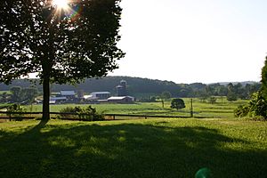
Dairy farm near Lisbon
|
|
| Country | |
| State | |
| County | Howard |
| Area | |
| • Total | 1.48 sq mi (3.83 km2) |
| • Land | 1.48 sq mi (3.82 km2) |
| • Water | 0.00 sq mi (0.01 km2) |
| Elevation | 577 ft (176 m) |
| Population
(2020)
|
|
| • Total | 282 |
| • Density | 191.06/sq mi (73.78/km2) |
| Time zone | UTC-5 (Eastern (EST)) |
| • Summer (DST) | UTC-4 (EDT) |
| FIPS code | 24-47250 |
| GNIS feature ID | 2806300 |
Lisbon is a small community in Howard County, Maryland, USA. It's located between the cities of Baltimore and Frederick, and north of Washington, D.C.. It covers an area of about one square mile. You can find Lisbon along Interstate 70 and Maryland Route 144. It's also known for having Maryland's very first roundabout, which opened in 1993. In the 2020 Census, Lisbon had a population of 282 people.
Lisbon's History
Lisbon started on a piece of land called "Warfield's Forest." This land was officially claimed by Seth Warfield in 1794. The town itself was founded by Caleb Pancoast in 1810. He first named it "New Lisbon," but later the name was shortened to just "Lisbon." This name is not related to Portugal's capital city.
In 1820, Caleb Pancoast gave land for a church called the Union Church for Public Worship. This building later became a schoolhouse, and some gravesites from that time were still there in 1880. In 1822, Pancoast divided the town into one hundred small lots, each about a quarter of an acre. He also planned the roads and alleys. By 1835, eight stagecoaches traveled through the town every day. Lisbon built the Annapolis Rock School in 1894, which was a single room. It served the area's students until 1943.
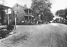
The old photograph shows the National Road, which is now Maryland Route 144. It's looking east toward Baltimore. The road between the two houses in the picture is Madison Street. Another important road, Woodbine Road, runs north from the center of town for about 2 miles (3.2 km) to Woodbine. There, the Patapsco River and the B&O Railroad cross the road. About one mile north of Lisbon, there's an older road that used to connect Baltimore to Frederick. This road goes west toward Poplar Springs and east toward Sykesville.
Lisbon was also home to the Carr's Mill Landfill. This was the second landfill in the county, and it closed in 1977. For the 2020 census, Lisbon changed from being an unincorporated community (a place without its own local government) to a census-designated place. This means the US Census Bureau now defines its boundaries for statistical purposes.
Who Lives in Lisbon?
| Historical population | |||
|---|---|---|---|
| Census | Pop. | %± | |
| 2020 | 282 | — | |
| U.S. Decennial Census 2020 |
|||
The 2020 Census counted 282 people living in Lisbon. This information helps us understand the different groups of people who make up the community.
Most of the people in Lisbon are White, making up about 82% of the population. About 8.5% of the residents are Asian. Other groups include Black or African American, Native American, and people of more than one race. A small percentage of the population is also of Hispanic or Latino background.
 | William L. Dawson |
 | W. E. B. Du Bois |
 | Harry Belafonte |


