Liberty Reservoir facts for kids
Quick facts for kids Liberty Reservoir |
|
|---|---|

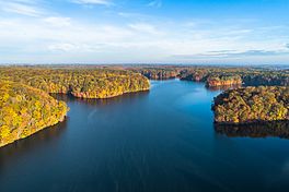
Aerial view of Liberty Reservoir
|
|
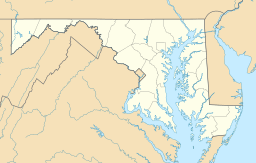
| Location | Baltimore / Carroll counties, near Eldersburg, Maryland |
| Coordinates | 39°25′04″N 76°52′44″W / 39.417895°N 76.878891°W |
| Type | reservoir |
| Primary inflows | North Branch Patapsco River |
| Primary outflows | North Branch Patapsco River |
| Basin countries | United States |
| Surface area | 4.73 sq mi (1,225 hectares) |
| Average depth | 59 ft (18 m) |
| Max. depth | 144 ft (44 m) |
| Water volume | 43×109 US gal (160,000,000 m3) |
| Surface elevation | 410 ft (120 m) (dam crest) |
Liberty Reservoir is a large lake located west of Baltimore, Maryland. It's about a mile north of a popular park called Patapsco Valley State Park. Even though it helps supply water to Baltimore City, the reservoir is actually outside the city limits. It sits right between Baltimore and Carroll Counties.
Contents
A Town Under Water
Before Liberty Reservoir was built, this area was home to a small town called Oakland Mill. There was also a large factory nearby, the Melville Woolen Mills. In the 1930s, the city started buying land from families like the Melvilles. People heard rumors that their town might be flooded, but many stayed.
Then, in 1942, it was officially announced that a reservoir would be built. By 1947, it became very real when workers arrived to cut down trees. This meant the town would soon be covered by water.
In 1951, the government bought the big Melville Woolen Mill. They also bought many farms and homes that were in the path of the future lake. People who lived and worked on these lands had to move away.
The old mill building was blown up with dynamite. Even after that, its tall walls stood for a while. It took several years for the water to rise and cover everything. Natural springs, small rivers, and other water sources slowly filled the area. This is how the large reservoir was created where Oakland Mills once stood. The water finally overflowed the dam for the first time on February 6, 1956.
Where Does the Water Come From?
The main river that fills Liberty Reservoir is the North Branch of the Patapsco River. Many smaller streams, called tributaries, also flow into it. These include Beaver Run, Morgan Run, and Cooks Branch, among others.
The reservoir stretches about 11 miles (18 km) long. When it's full, its shoreline is about 81 miles (130 km) long. The water is usually about 59 feet (18 meters) deep. But in some spots, it can be as deep as 144 feet (44 meters)!
Fun Things to Do at Liberty Reservoir
Liberty Reservoir is a great place for many outdoor activities. You can go biking on the trails, boating on the water, or hiking along the shore. It's also a popular spot for fishing and watching birds. Many people simply come to relax and enjoy nature.
However, some activities are not allowed to keep everyone safe and protect the water. For example, you cannot go camping or start fires. Swimming is also not permitted in the reservoir. Police officers from the Baltimore Environmental Police patrol the area to make sure everyone follows the rules. The trails around the reservoir are mostly unpaved roads. They are usually kept clear for people to use.
See also
 In Spanish: Liberty Reservoir para niños
- Piney Run Reservoir
- Union Mills Reservoir
 | John T. Biggers |
 | Thomas Blackshear |
 | Mark Bradford |
 | Beverly Buchanan |


