Monocacy River facts for kids
Quick facts for kids Monocacy River |
|
|---|---|

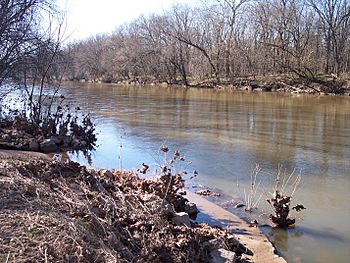
The Monocacy River near Frederick in 2007
|
|

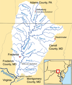
The Monocacy River watershed
|
|
| Native name | Monnockkesey |
| Country | United States |
| State | Maryland |
| City | Frederick |
| Physical characteristics | |
| Main source | Harney, Carroll County, Maryland, United States 400 ft (120 m) 39°43′11″N 77°13′03″W / 39.71972°N 77.21750°W |
| River mouth | Potomac River Dickerson, Maryland, United States 200 ft (61 m) 39°13′22″N 77°27′15″W / 39.22278°N 77.45417°W |
| Length | 58 mi (93 km) |
| Discharge (location 2) |
|
| Basin features | |
| Basin size | 970 sq mi (2,500 km2) |
| Tributaries |
|
The Monocacy River is a river in the United States. It flows into the Potomac River, which then goes to the Atlantic Ocean through the Chesapeake Bay. This river is about 58.5 miles (94 km) long. It drains an area of about 970 square miles (2,500 km²). It is the biggest river in Maryland that flows into the Potomac.
The name "Monocacy" comes from the Shawnee language. It means "river with many bends." Some people also say it means "well-fenced garden" in an old Native American language. The first town settled in Western Maryland, also called Monocacy, was named after this river.
A famous place called the Monocacy National Battlefield is next to the river. This battlefield marks an important event from the American Civil War in 1864. It was the Battle of Monocacy Junction. The Chesapeake and Ohio Canal crosses over the river at the Monocacy Aqueduct. This aqueduct is the largest of 11 such structures on the canal.
Where Does the Monocacy River Flow?
The Monocacy River starts in Carroll County, Maryland. This is west of a small town called Harney. It is near the border between Maryland and Pennsylvania. The river forms when two smaller streams, Marsh Creek and Rock Creek, join together. These streams come from Adams County, Pennsylvania.
Many smaller streams flow into the Monocacy River. In Maryland, these include Furnace Branch, Tuscarora Creek, Carroll Creek, Linganore Creek, and Ballenger Creek. These are all in Frederick County. Double Pipe Creek also joins it from Carroll County. In Pennsylvania, Alloway Creek and Toms Creek flow into it.
About 60% of the land around the Monocacy River is used for farming. About 33% of the land is covered by forests. The city of Frederick and its nearby towns make up the largest city area in the river's watershed. A watershed is the area of land where all the water drains into a specific river.
What Are the Water Quality Challenges?
The State of Maryland named the Monocacy a Maryland Scenic River in 1974. However, it faces big challenges with nonpoint source pollution. This type of pollution comes from many places, not just one pipe. It is mostly from runoff from farms and livestock operations in the area.
The Maryland Department of the Environment (MDE) says the Monocacy River has poor water quality. This is due to too much sediment (dirt and sand) and fecal coliform bacteria. A major stream that flows into the Monocacy, called Double Pipe Creek, also has problems with sediment and bacteria.
Farmers in the Monocacy watershed are working to help. Some join the national Conservation Security Program. This program helps farmers reduce pollution from erosion and runoff. In the 1990s, a project helped farmers use less fertilizer. This reduced the amount of nitrogen and phosphorus flowing into the river.
How Can We Improve River Health?
One way to help the river is by using "green solutions." These are natural ways to clean water. For example, using buffer strips or biofiltration systems can treat stormwater. This helps reduce the amount and speed of water entering the river.
Green solutions have many benefits for the river and the land:
- They reduce the amount of runoff water.
- Water stays in the system longer, getting cleaner.
- They improve habitat for plants and animals.
- They help save soil from washing away.
- They create nice green spaces.
- They can increase property value.
- They are often low-cost and have little impact.
- They encourage planting native plants.
- They help restore and improve stream health.
In cities, the goal is to treat stormwater where it falls. This helps stop sudden rushes of water that carry dirt, nutrients, and trash into the river. It also helps prevent the riverbed from being washed away, making the riverbanks more stable.
For both city and farm areas, planting vegetative buffer strips is important. These are strips of plants, like grasses or trees, along the edges of streams. They act like a filter. Experts agree that a buffer at least 35 feet (10.7 meters) wide on each side of a waterway is best. Even a 15-foot (4.6 meters) buffer can make a big difference.
Thicker buffers with trees are the best for protecting streams and removing pollution. They also add to the variety of plants and animals in the area. Trees help keep the water cool by providing shade. They also create places for animals to live when branches fall into the water.
Grass and shrub buffers are also helpful. They stabilize the soil and banks. They slow down water flowing into the stream. This helps keep soil and nutrients on the land where they belong.
 | Kyle Baker |
 | Joseph Yoakum |
 | Laura Wheeler Waring |
 | Henry Ossawa Tanner |


