Linganore Creek facts for kids
Quick facts for kids Linganore Creek |
|
|---|---|

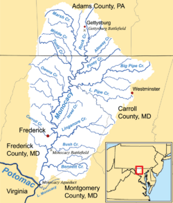
Watershed map showing Linganore Creek
|
|
| Country | United States |
| State | Maryland |
| Region | Western Maryland |
| Cities | Frederick, New Market, Mount Airy |
| Physical characteristics | |
| Main source | Church Creek, Maryland |
| River mouth | Monocacy River Frederick, MD 0 ft (0 m) |
| Basin features | |
| Tributaries |
|
Linganore Creek is a stream about 13.5 miles (21.7 km) long. It flows into the Monocacy River in Frederick County, Maryland. A stream that flows into a larger river is called a tributary.
This creek starts where its north and south branches join together. This meeting point is about 10 miles (16 km) east-northeast of Frederick. The creek then flows generally southwest until it reaches the Monocacy River. The Monocacy River eventually flows into the Potomac River.
The area of land that drains water into Linganore Creek is called its watershed. This watershed covers about 83.1 square miles (215 km²). When there is a lot of rain, the water level in the creek can get very high. This can sometimes cause flooding on nearby roads like Gas House Pike.
The name "Linganore" has an interesting story. It is said to mean "left ear" of the Potomac River. An American Indian chief who lived by the creek long ago supposedly gave it this name.
Lake Linganore: A Water Source
Lake Linganore is a large lake built on Linganore Creek. It was created by building a dam across the creek. The lake is located about 4 miles (6.4 km) east of Frederick.
This lake is very important because it provides drinking water for the city of Frederick. It also supplies drinking water to other parts of central Frederick County. The community of Lake Linganore is named after this important lake.
 | Emma Amos |
 | Edward Mitchell Bannister |
 | Larry D. Alexander |
 | Ernie Barnes |

