Erie County, Pennsylvania facts for kids
Quick facts for kids
Erie County
|
|||
|---|---|---|---|
|
|||
|
|||
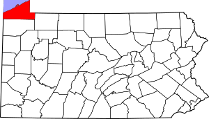
Location within the U.S. state of Pennsylvania
|
|||
 Pennsylvania's location within the U.S. |
|||
| Country | |||
| State | |||
| Founded | November 7, 1803 | ||
| Named for | Erie people | ||
| Seat | Erie | ||
| Largest city | Erie | ||
| Area | |||
| • Total | 1,558 sq mi (4,040 km2) | ||
| • Land | 799 sq mi (2,070 km2) | ||
| • Water | 759 sq mi (1,970 km2) 49% | ||
| Population
(2020)
|
|||
| • Total | 270,876 | ||
| • Density | 339.1/sq mi (130.9/km2) | ||
| Time zone | UTC−5 (Eastern) | ||
| • Summer (DST) | UTC−4 (EDT) | ||
| Congressional district | 16th | ||
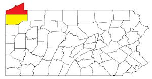
Erie County is a county in the state of Pennsylvania. It is the northernmost county in Pennsylvania. In 2020, about 270,876 people lived here. Its main city and government center is Erie. The county was officially created in 1800 and started its government in 1803. It is part of the Northwest Pennsylvania region.
Contents
History of Erie County
Erie County was formed on March 12, 1800. It was created from a part of Allegheny County. Before 1792, both New York and Pennsylvania claimed this land. The United States government stepped in, and Pennsylvania bought the area known as the Erie Triangle.
When Erie County was new, it couldn't support itself alone. So, it joined with four nearby counties (Crawford, Mercer, Venango, and Warren). They shared a temporary government in Meadville. Erie County elected its own officials in 1803. Sadly, in 1823, the Erie County Courthouse burned down. All county records from before that time were lost.
The first settlers in Erie County were mostly from New England and New York. They were called "Yankees." These families had moved from New England after the Revolutionary War. This meant Erie County had a culture very similar to early New England.
Erie County was also an important part of the Underground Railroad. This was a secret network that helped enslaved people escape to freedom. They could travel through Lake Erie to Canada, or east through New York State. Many also found safety in Erie with the help of people who were against slavery and the free Black community.
Geography and Climate
Erie County covers about 1,558 square miles. About 799 square miles are land, and 759 square miles (49%) are water. It is the largest county in Pennsylvania by total area. The land is generally rolling, with a high ridge near the lake. Erie County is the only county in Pennsylvania that extends north of the 42nd parallel.
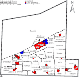
There are two cities in Erie County: Erie and Corry. Other important areas include Millcreek, Harborcreek, Summit, and Fairview townships. The boroughs of Edinboro, North East, Girard, Waterford, and Union City are also notable.
Erie County shares borders with several other counties. To the northeast is Chautauqua County, New York. To the east is Warren County. To the south is Crawford County. To the west is Ashtabula County, Ohio. Directly north of the county is Lake Erie. This location means Erie County is the only county in Pennsylvania that borders Canada. Canada is on the far side of Lake Erie.
Most of Erie County has a warm-summer humid continental climate. This means it has warm summers and cold winters. Near the lake, it can be a bit warmer in summer. For example, in downtown Erie, the average temperature is about 26.4°F in January and 70.8°F in July.
Because of its location, Erie County is unique. It is the only county in Pennsylvania that borders both New York and Ohio. It is also the only county in the state that touches the Canadian border (across Lake Erie).
Neighboring Counties
- Haldimand County, Ontario (north)
- Norfolk County, Ontario (northwest)
- Chautauqua County, New York (northeast)
- Warren County (southeast)
- Crawford County (south)
- Ashtabula County, Ohio (southwest)
Main Roads
Population and Demographics
Erie County has grown a lot since it was founded. In 1800, there were only 1,468 people. By 2020, the population had grown to 270,876.
| Race | Number of People | Percentage |
|---|---|---|
| White (Non-Hispanic) | 219,180 | 81% |
| Black or African American (Non-Hispanic) | 19,821 | 7.32% |
| Native American (Non-Hispanic) | 343 | 0.13% |
| Asian (Non-Hispanic) | 6,358 | 2.35% |
| Pacific Islander (Non-Hispanic) | 58 | 0.02% |
| Other/Mixed (Non-Hispanic) | 13,086 | 4.83% |
| Hispanic or Latino | 12,030 | 4.44% |
In 2010, there were about 110,413 households in the county. About 27.2% of these households had children under 18 living with them. The average age of people in the county was 38.6 years. For every 100 females, there were about 96.73 males.
Major Population Centers
The largest cities and towns in Erie County are listed below.
| 2023 Rank | City/Town | Type | 2023 Estimate | 2020 Census | Highest Population (Year) |
|---|---|---|---|---|---|
| 1 | Erie | City | 92,957 | 94,852 | 138,440 (1960) |
| 2 | Millcreek | Township | 53,101 | 54,070 | 54,256 (2013) |
| 3 | Harborcreek | Township | 16,580 | 16,630 | 17,629 (2014) |
| 4 | Fairview | Township | 11,270 | 11,139 | 11,270 (2023) |
| 5 | Summit | Township | 7,273 | 7,339 | 7,339 (2020) |
| 6 | North East | Township | 6,439 | 6,529 | 7,702 (2000) |
| 7 | Corry | City | 6,075 | 6,208 | 7,911 (1950) |
| 8 | Edinboro | Borough | 5,821 | 4,963 | 7,736 (1990) |
Education in Erie County
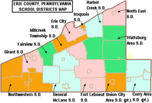
Erie County has many public school districts that serve its students.
Public School Districts
- Corry Area School District
- Erie City School District
- Fairview School District
- Fort LeBoeuf School District
- General McLane School District
- Girard School District
- Harbor Creek School District
- Iroquois School District
- Millcreek Township School District
- North East School District
- Northwestern School District
- Union City Area School District
- Wattsburg Area School District
Community College
In 2017, the Erie County Council decided to support a new community college. This college helps students get a good education close to home. Many local leaders and groups supported this idea.
Fun and Recreation
Erie County offers many places for fun and outdoor activities.
State Parks
There are two Pennsylvania state parks in Erie County. Both are located on the shores of Lake Erie.
- Erie Bluffs State Park – This is one of Pennsylvania's newer state parks.
- Presque Isle State Park – This is one of Pennsylvania's oldest and most-visited state parks in Pennsylvania.
Things to Do
- Splash Lagoon Indoor Waterpark
- Millcreek Mall
- Presque Isle Downs and Casino
- Presque Isle State Park
- Erie Zoo
- Tom Ridge Environmental Center
- Erie Maritime Museum
- Warner Theatre
- Erie Art Museum
- Waldameer Park
- Erie County Public Library
Annual Events
- Roar on the Shore
Libraries in Erie County
The main public library in Erie is the Raymond M. Blasco, M. D. Memorial Library. It opened in 1996 and is now called the Main Library or the Erie County Public Library. It is the third-largest library in Pennsylvania. This library is connected to the Erie Maritime Museum. Both are part of a project to improve the bayfront area. This area also includes the Bayfront Convention Center and the Bicentennial Tower.
The Main Library is known for its beautiful views of Presque Isle Bay. You can often see the historic U.S. Brig Niagara from here. The library also has an art collection on its second floor. This collection includes historical pieces and works by local artists. The library helps new immigrants by offering tours and foreign-language books. It also has a special room for genealogy research. Here, you can learn about your ancestors who lived in Erie County.
Erie County has several other public libraries. These include branches in Edinboro, Iroquois Avenue, Lincoln Community Center, and Millcreek. Other libraries are in Albion, Corry, McCord Memorial, Rice Avenue, Union City, and Waterford.
Communities in Erie County
Pennsylvania law has four types of official communities: cities, boroughs, townships, and sometimes towns. Erie County has 38 official communities. These include 2 cities, 14 boroughs, and 22 townships.
Cities
Boroughs
Townships
- Amity Township
- Concord Township
- Conneaut Township
- Elk Creek Township
- Fairview Township
- Franklin Township
- Girard Township
- Greene Township
- Greenfield Township
- Harborcreek Township
- Lawrence Park Township
- LeBoeuf Township
- McKean Township
- Millcreek Township
- North East Township
- Springfield Township
- Summit Township
- Union Township
- Venango Township
- Washington Township
- Waterford Township
- Wayne Township
Census-Designated Places (CDPs)
These are special areas defined by the U.S. Census Bureau for data collection. They are not official towns under Pennsylvania law.
- Avonia
- Fairview
- Lawrence Park
- Northwest Harborcreek
- Penn State Erie (Behrend)
Population Ranking of Communities (2010 Census)
† county seat
| Rank | City/Town/etc. | Type of Community | Population (2010 Census) |
|---|---|---|---|
| 1 | † Erie | City | 101,786 |
| 2 | Northwest Harborcreek | CDP | 8,949 |
| 3 | Corry | City | 6,605 |
| 4 | Edinboro | Borough | 6,438 |
| 5 | North East | Borough | 4,294 |
| 6 | Lawrence Park | CDP | 3,982 |
| 7 | Wesleyville | Borough | 3,341 |
| 8 | Union City | Borough | 3,320 |
| 9 | Girard | Borough | 3,104 |
| 10 | Lake City | Borough | 3,031 |
| 11 | Fairview | CDP | 2,348 |
| 12 | Penn State Erie (Behrend) | CDP | 1,629 |
| 13 | Waterford | Borough | 1,517 |
| 14 | Albion | Borough | 1,516 |
| 15 | Avonia | CDP | 1,205 |
| 16 | Cranesville | Borough | 638 |
| 17 | Platea | Borough | 430 |
| 18 | Mill Village | Borough | 412 |
| 19 | Wattsburg | Borough | 403 |
| 20 | McKean | Borough | 388 |
| 21 | Elgin | Borough | 218 |
Images for kids
See also
 In Spanish: Condado de Erie (Pensilvania) para niños
 | Bessie Coleman |
 | Spann Watson |
 | Jill E. Brown |
 | Sherman W. White |


