
Warren County, Pennsylvania facts for kids
Quick facts for kids
Warren County
|
|
|---|---|

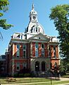
Warren County Courthouse
|
|

Location within the U.S. state of Pennsylvania
|
|
 Pennsylvania's location within the U.S. |
|
| Country | |
| State | |
| Founded | October 1, 1819 |
| Named for | Joseph Warren |
| Seat | Warren |
| Largest city | Warren |
| Area | |
| • Total | 899 sq mi (2,330 km2) |
| • Land | 884 sq mi (2,290 km2) |
| • Water | 14.1 sq mi (37 km2) 1.6%% |
| Population
(2020)
|
|
| • Total | 38,587 |
| • Density | 44/sq mi (17/km2) |
| Time zone | UTC−5 (Eastern) |
| • Summer (DST) | UTC−4 (EDT) |
| Congressional district | 15th |
Warren County is a county in Pennsylvania. It is like a special area within the state. In 2020, about 38,587 people lived here. The main town, or county seat, is Warren.
The county was created in 1800. It was officially set up in 1819. Warren County is also part of a larger area called the Warren, Pennsylvania micropolitan statistical area. This means it's a smaller city area that is connected to nearby towns.
Contents
Geography
Warren County covers a total area of about 899 square miles. Most of this is land, about 884 square miles. The rest, about 14 square miles, is water.
Some important natural features in the county include the Allegheny River. There is also the Allegheny Reservoir and the Kinzua Dam. A large part of the Allegheny National Forest is also found here.
Climate
Warren County has a climate with warm summers. This means summers are usually warm and winters are cold. In the town of Warren, the average temperature in January is about 24.5°F. In July, it's about 69.3°F.
| Climate data for CHANDLERS VALLEY 1SE, PA (1991-2020 normals) (Records 2004-Present) | |||||||||||||
|---|---|---|---|---|---|---|---|---|---|---|---|---|---|
| Month | Jan | Feb | Mar | Apr | May | Jun | Jul | Aug | Sep | Oct | Nov | Dec | Year |
| Record high °F (°C) | 65 (18) |
73 (23) |
80 (27) |
85 (29) |
91 (33) |
93 (34) |
98 (37) |
91 (33) |
92 (33) |
85 (29) |
76 (24) |
65 (18) |
98 (37) |
| Mean daily maximum °F (°C) | 30.7 (−0.7) |
33.5 (0.8) |
42.7 (5.9) |
56.7 (13.7) |
68.4 (20.2) |
76.9 (24.9) |
80.4 (26.9) |
78.7 (25.9) |
72.6 (22.6) |
59.6 (15.3) |
46.5 (8.1) |
35.6 (2.0) |
56.9 (13.8) |
| Daily mean °F (°C) | 22.0 (−5.6) |
22.9 (−5.1) |
31.3 (−0.4) |
43.3 (6.3) |
54.2 (12.3) |
63.0 (17.2) |
66.8 (19.3) |
65.4 (18.6) |
59.1 (15.1) |
47.8 (8.8) |
37.1 (2.8) |
27.9 (−2.3) |
45.1 (7.3) |
| Mean daily minimum °F (°C) | 13.2 (−10.4) |
12.3 (−10.9) |
19.9 (−6.7) |
29.9 (−1.2) |
40.1 (4.5) |
49.2 (9.6) |
53.2 (11.8) |
52.2 (11.2) |
45.6 (7.6) |
36.0 (2.2) |
27.6 (−2.4) |
20.2 (−6.6) |
33.3 (0.7) |
| Record low °F (°C) | −21 (−29) |
−32 (−36) |
−25 (−32) |
8 (−13) |
22 (−6) |
30 (−1) |
37 (3) |
38 (3) |
27 (−3) |
19 (−7) |
2 (−17) |
−14 (−26) |
−32 (−36) |
| Average precipitation inches (mm) | 3.73 (95) |
2.47 (63) |
3.36 (85) |
4.17 (106) |
4.39 (112) |
4.61 (117) |
5.52 (140) |
4.09 (104) |
4.22 (107) |
4.33 (110) |
3.97 (101) |
4.01 (102) |
48.87 (1,241) |
| Average snowfall inches (cm) | 31.4 (80) |
26.5 (67) |
12.7 (32) |
6.7 (17) |
0.1 (0.25) |
0.0 (0.0) |
0.0 (0.0) |
0.0 (0.0) |
0.0 (0.0) |
0.6 (1.5) |
9.7 (25) |
28.0 (71) |
115.7 (294) |
| Average precipitation days (≥ 0.01 in) | 21.2 | 17.3 | 15.5 | 16.3 | 14.4 | 14.2 | 13.1 | 12.6 | 11.3 | 16.5 | 15.5 | 19.4 | 187.3 |
| Average snowy days (≥ 0.1 in) | 13.4 | 11.7 | 6.3 | 2.8 | 0.1 | 0.0 | 0.0 | 0.0 | 0.0 | 0.4 | 3.9 | 10.2 | 48.8 |
| Source: NOAA | |||||||||||||
Neighboring Counties
Warren County shares borders with these other counties:
- Chautauqua County, New York (north)
- Cattaraugus County, New York (northeast)
- McKean County (east)
- Elk County (southeast)
- Forest County (south)
- Venango County (south)
- Crawford County (west)
- Erie County (west)
Protected Natural Areas
Parts of these special protected areas are in Warren County:
- Allegheny National Forest
- Allegheny National Recreation Area
Main Roads
These are the major highways that run through Warren County:
 US 6
US 6 US 62
US 62 PA 27
PA 27 PA 59
PA 59 PA 69
PA 69 PA 127
 PA 346
 PA 426
 PA 666
 PA 948
 PA 957
 PA 958
Fun Things to Do
Warren County has a great place for outdoor fun!
- Chapman State Park is a Pennsylvania state park here. It's next to the Allegheny National Forest. You can find it near Clarendon.
- The county also has a very old forest called Hearts Content National Scenic Area. It's a special place with very old trees.
People and Population
| Historical population | |||
|---|---|---|---|
| Census | Pop. | %± | |
| 1800 | 233 | — | |
| 1810 | 827 | 254.9% | |
| 1820 | 1,976 | 138.9% | |
| 1830 | 4,697 | 137.7% | |
| 1840 | 9,278 | 97.5% | |
| 1850 | 13,671 | 47.3% | |
| 1860 | 19,190 | 40.4% | |
| 1870 | 23,897 | 24.5% | |
| 1880 | 27,981 | 17.1% | |
| 1890 | 37,585 | 34.3% | |
| 1900 | 38,946 | 3.6% | |
| 1910 | 39,573 | 1.6% | |
| 1920 | 40,024 | 1.1% | |
| 1930 | 41,453 | 3.6% | |
| 1940 | 42,789 | 3.2% | |
| 1950 | 42,698 | −0.2% | |
| 1960 | 45,582 | 6.8% | |
| 1970 | 47,682 | 4.6% | |
| 1980 | 47,449 | −0.5% | |
| 1990 | 45,050 | −5.1% | |
| 2000 | 43,863 | −2.6% | |
| 2010 | 41,815 | −4.7% | |
| 2020 | 38,587 | −7.7% | |
| U.S. Decennial Census 1790-1960 1900-1990 1990-2000 2010-2017 2010-2020 |
|||
In 2000, there were 43,863 people living in Warren County. About 17,696 households were counted. A household is a group of people living in one home.
Most people in the county were White (98.68%). Smaller groups included Black or African American, Native American, and Asian people. About 0.34% of the population was Hispanic or Latino.
Many people living here have roots from different countries. The largest groups were from German, Swedish, Irish, English, Italian, and Polish backgrounds.
About 29.80% of households had children under 18. The average family size was about 2.93 people. The median age in the county was 40 years old. This means half the people were younger than 40, and half were older.
2020 Census Information
Here's a quick look at the different groups of people in Warren County from the 2020 census:
| Race | Num. | Perc. |
|---|---|---|
| White (NH) | 36,310 | 94.1% |
| Black or African American (NH) | 144 | 0.37% |
| Native American (NH) | 71 | 0.18% |
| Asian (NH) | 154 | 0.4% |
| Pacific Islander (NH) | 5 | 0.01% |
| Other/Mixed (NH) | 1,488 | 4% |
| Hispanic or Latino | 415 | 1% |
Education

Kids in Warren County go to different types of schools.
Public Schools
These are the main public school districts:
- Corry Area School District
- Titusville Area School District
- Warren County School District (This district has four high schools.)
Charter Schools
- Tidioute Community Charter School is a special public school. It has more freedom in how it operates.
Vocational School
- Warren County Area Vocational Technical School teaches students job skills.
Private Schools
Many private schools are also in Warren County:
- Beaver Valley Amish School
- Calvary Chapel Christian School
- Cozy Corners Amish School
- Early Childhood Learning Center
- Forest Amish School
- HR Rouse Children's Center
- Little Ash Parochial School, Sugar Grove
- Meadow View Amish School, Sugar Grove
- Pine Ridge School
- Railroad School
- Round Hill School
- Ruth Smith Children's Home
- St Joseph School
- Stoney Run Amish School
- Warren County Christian School
Communities

Warren County has different kinds of towns and areas. In Pennsylvania, these are called cities, boroughs, or townships.
City
- Warren is the biggest city and the county seat.
Boroughs
Boroughs are smaller towns:
- Bear Lake
- Clarendon
- Sugar Grove
- Tidioute
- Youngsville
Townships
Townships are areas that usually include rural land and smaller communities:
- Brokenstraw
- Cherry Grove
- Columbus
- Conewango
- Deerfield
- Eldred
- Elk
- Farmington
- Freehold
- Glade
- Limestone
- Mead
- Pine Grove
- Pittsfield
- Pleasant
- Sheffield
- Southwest
- Spring Creek
- Sugar Grove
- Triumph
- Watson
Census-Designated Places (CDPs)
These are areas that the U.S. Census Bureau names for collecting data. They are not official towns or cities:
Other Communities
Some communities are not officially incorporated or designated by the census:
Old Towns (Ghost Towns)
These are places that used to be towns but are no longer populated:
- Cornplanter Reservation
- Corydon
- Kinzua
Images for kids
-
Warren County Courthouse
See also
 In Spanish: Condado de Warren (Pensilvania) para niños
