
Allegheny River facts for kids
Quick facts for kids Allegheny River |
|
|---|---|

The Allegheny River, looking upstream at Freeport, Pennsylvania
|
|
| Country | United States |
| State | Pennsylvania, New York |
| Physical characteristics | |
| Main source | Allegany Township, Potter County, near Coudersport, Pennsylvania at the corner of Ben Green and Cobb Hill Rd 2,450 feet (750 m) 41°52′22″N 77°52′30″W / 41.8728449°N 77.874998°W |
| River mouth | Ohio River at Pittsburgh, Pennsylvania 712 feet (217 m) 40°26′36″N 80°00′54″W / 40.4434025°N 80.0150536°W |
| Length | 325 miles (523 km) |
| Basin features | |
| Progression | Allegheny River → Ohio River → Mississippi River → Gulf of Mexico |
| Basin size | 11,580 square miles (30,000 km2) |
| Tributaries | |
| Type: | Recreational |
| Designated: | April 20, 1992 |
The Allegheny River (pronounced AL-ə-GAY-nee) is a long river, about 325-mile (523 km) (523 km) in length. It's like the main starting point for the Ohio River in western Pennsylvania and New York.
This river begins in north-central Pennsylvania. It then flows north into New York, makes a zigzag turn, and heads southwest back into Pennsylvania. Finally, it meets the Monongahela River in Downtown Pittsburgh, Pennsylvania. This meeting point is called the "Point" at Point State Park. When the Allegheny and Monongahela rivers join, they form the mighty Ohio River.
The Allegheny River is very important because it's the biggest source of water for both the Ohio River and the huge Mississippi River. Long ago, both Native Americans and early European settlers thought of the Allegheny as the upper part of the Ohio River itself.
Even though parts of the river are shallow, people can travel by boat from Pittsburgh up to East Brady. This was made possible by building a series of locks and dams in the early 1900s. A 24-mile (39 km) section of the river in Pennsylvania and New York is now the Allegheny Reservoir. This large lake, also known as Lake Kinzua, was created in 1965 by building the Kinzua Dam to help control floods.
The name "Allegheny" comes from different phrases used by the Delaware Indian people. These phrases sound similar to the English name and have various meanings.
Contents
Where Does the Allegheny River Start?
The Allegheny River begins in north-central Pennsylvania. Its source is on Cobb Hill in Allegany Township, Potter County. This spot is about 8 miles (13 km) south of the New York border.

The river first flows south, passing under Pennsylvania Route 49 near Coudersport. A historical marker there tells you where the river starts. It then continues west to Port Allegany.
How Does the River Flow?
After Port Allegany, the Allegheny River turns north into western New York. It makes a big loop westward through southern Cattaraugus County for about 30 miles (48 km). Along this path, it flows past towns like Portville, Olean, and Salamanca. It also passes through lands belonging to the Seneca Indian Nation.
The river then re-enters northwestern Pennsylvania and flows into the Allegheny Reservoir. From there, it takes a wide zigzag path, generally flowing southwest across Western Pennsylvania. It goes past towns such as Warren, Oil City, and Franklin. For much of this part, it forms the northwestern edge of the Allegheny National Forest.
South of Franklin, the river turns southeast through Clarion County. It then turns southwest again, flowing through Armstrong County, past towns like Kittanning and Freeport.

Finally, the Allegheny River reaches Allegheny and Westmoreland counties, which include the suburbs of Pittsburgh and the city itself. It flows past the North Side and downtown Pittsburgh, eventually meeting the Monongahela River at the "Point" to form the Ohio River.
What is the River's Watershed Like?
.jpg)

The Allegheny River is about 325 miles (523 km) (523 km) long and flows through New York and Pennsylvania. It drains a large area of land, about 11,580 square miles (30,000 km2), which is mostly a hilly, rural area called the Allegheny Plateau. This area is the northeasternmost part of the huge Mississippi River watershed. This means that all the water from the Allegheny River eventually flows into the Gulf of Mexico through the Ohio and Mississippi rivers.
The Allegheny Valley has been a very important place for getting fossil fuels like coal, petroleum (oil), and natural gas. There are many deposits of these resources found here.
Major Streams Joining the Allegheny
Many smaller streams and rivers flow into the Allegheny River along its path. These are called tributaries.
In its upper parts, the Allegheny is joined by Potato Creek and Olean Creek. Further downstream, Tunungwant "Tuna" Creek and the Great Valley Creek also add their waters.
After the river re-enters Pennsylvania, it is joined by Kinzua Creek, Conewango Creek, and Brokenstraw Creek. Other important tributaries include Tionesta Creek, Oil Creek, and French Creek.
As it continues, the Clarion River and the Kiskiminetas River are two other major tributaries that flow into the Allegheny. Many more streams, like Buffalo Creek and Girtys Run, also join the river before it reaches Pittsburgh.
How is the River Controlled and Crossed?

To make the Allegheny River easier for boats to travel, several locks and dams were built in the early 1900s. These structures allow boats to move up and down the river, even when the water level changes. There are eight main locks and dams on the Allegheny River, numbered two through nine. Each dam creates a reservoir, which is like a lake, behind it.
The biggest dam on the river is the Kinzua Dam in northwestern Pennsylvania. This dam created the large Allegheny Reservoir, also known as Kinzua Lake. This dam is important for controlling floods and also has a power plant called the Seneca Pumped Storage Generating Station that helps produce electricity.
Many bridges cross the Allegheny River, allowing people and cars to get from one side to the other. There's even a tunnel, the Allegheny River Tunnel, that goes under the river. It's used by the Pittsburgh Light Rail system and opened in 2012.
Images for kids
-
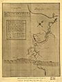
The Allegheny River is named as Ohio on a sketch by George Washington.
-
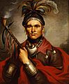
Seneca Chief Cornplanter
-
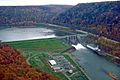
The Kinzua Dam and Allegheny Reservoir
-
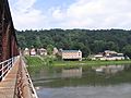
The Allegheny River at Foxburg, Pennsylvania
-
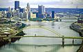
The Allegheny (left) and Monongahela (right) join to form the Ohio River at Pittsburgh, Pennsylvania.


See also
 In Spanish: Río Allegheny para niños
