Allegheny Islands State Park facts for kids
Quick facts for kids Allegheny Islands State Park |
|
|---|---|
|
IUCN Category V (Protected Landscape/Seascape)
|
|

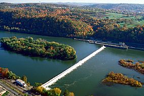
The eastern part of Allegheny Islands State Park and the C. W. Bill Young Lock and Dam (No. 3) on the Allegheny River
|
|
| Location | Allegheny County, Pennsylvania |
| Area | 43 acres (17 ha) |
| Elevation | 735 feet (224 m) |
| Established | 1980 |
| Named for | Allegheny River islands |
| Administrator | Pennsylvania Department of Conservation and Natural Resources |
| Allegheny Islands State Park | |
| Pennsylvania State Parks | |
Allegheny Islands State Park is a special place in Pennsylvania. It's a 43-acre state park located in Harmar Township, Allegheny County. This park is made up of three islands in the middle of the Allegheny River. You can find them northeast of Pittsburgh. The islands are near the towns of Oakmont, Plum, and Cheswick. Big bridges cross the river at the middle island. These include the Pennsylvania Turnpike (Interstate 76) and a railroad bridge.
Contents
Exploring the Islands
The park covers 43 acres across its islands. Two of the islands are located downstream from the C. W. Bill Young Lock and Dam. The third island is upstream.
- Twelve Mile Island is the farthest downstream, or west. Most of this island has houses and buildings. The park land is on its eastern side.
- Fourteen Mile Island is the middle island. It used to be one big island, but the dam split it into two parts. This island is where the highway and railroad bridges cross the river.
- Unnamed Island is the easternmost island. It was once part of Fourteen Mile Island. This island is the only one located upstream from the dam.
These islands are called "alluvial" islands. This means they were formed by sand, silt, and clay carried by the river. Sometimes, small sandbars called "shoals" can be seen near the islands when the water is low.
Why are they called Twelve and Fourteen Mile Islands?
The names "Twelve Mile Island" and "Fourteen Mile Island" tell you how far they are from downtown Pittsburgh. They are 12 miles and 14 miles up the Allegheny River. This distance is measured from where the Allegheny River meets the Monongahela River. Together, these two rivers form the Ohio River.
The Allegheny River has many islands near Pittsburgh. The Ohio River has only three, and the Monongahela River has none. This is because the Allegheny River carried a lot of sediment from glaciers long ago.
Park Activities and Access

Allegheny Islands State Park was created on December 31, 1980. It is kept undeveloped on purpose. This means there are no buildings or facilities like restrooms or visitor centers. There are also no plans to build any in the future.
The only way to reach the park is by boat. You can go camping on the islands. Groups like the Boy Scouts and Venture Outdoors often visit the park. The park is managed by the Region 2 Office in Prospect, Pennsylvania.
Nearby State Parks
Here are some other state parks within 30 miles of Allegheny Islands State Park:
- Hillman State Park (Washington County)
- Keystone State Park (Westmoreland County)
- Point State Park (Allegheny County)
 | Misty Copeland |
 | Raven Wilkinson |
 | Debra Austin |
 | Aesha Ash |


