
Point State Park facts for kids
Quick facts for kids Point State Park |
|
|---|---|
|
IUCN Category V (Protected Landscape/Seascape)
|
|

Point State Park in Fall
|
|

Point State Park
Location in Pennsylvania
|
|
| Location | Pittsburgh, Allegheny, Pennsylvania, United States |
| Area | 36 acres (15 ha) |
| Elevation | 718 ft (219 m) |
| Established | August 1974 [1] |
| Named for | the point of confluence of the Allegheny and Monongahela rivers forming the Ohio River |
| Governing body | Pennsylvania Department of Conservation and Natural Resources |
| Website | Point State Park |
|
Forks of the Ohio
|
|
| NRHP reference No. | 66000643 |
|---|---|
| Significant dates | |
| Added to NRHP | October 15, 1966 |
| Designated NHL | October 9, 1960 |
Point State Park, often called The Point, is a special park in Pittsburgh, Pennsylvania. It covers about 36 acres (14.5 hectares) right in the middle of the city. This park is famous because it's where the Allegheny River and the Monongahela River meet to form the mighty Ohio River.
The park was created in the 1950s. The land was bought from old industrial businesses. It officially opened in August 1974, after its famous fountain was finished. Interestingly, a different plan for a big civic center designed by the famous architect Frank Lloyd Wright was considered but not chosen.
Point State Park also holds the remains of two very old forts: Fort Pitt and Fort Duquesne. These forts played a big part in early American history. The Fort Pitt Museum is located inside the park. It teaches visitors about the French and Indian War (1754–1763). This area was a major battlefield during that war. The park was named a National Historic Landmark in 1960. This was because of its important role in battles between Native Americans, French, and British colonists. They all wanted control of the Ohio River area.
Contents
Fun Things to Do at Point State Park
Today, Point State Park is a popular spot for everyone in downtown Pittsburgh. People come here to relax, play, and enjoy the outdoors. It's also a major place for big events in the city.
Events and Activities at the Park
The park hosts many exciting cultural events. These include the Venture Outdoors Festival, the Three Rivers Arts Festival, and the Pittsburgh Three Rivers Regatta. The park is managed by the Pennsylvania Bureau of State Parks. They make sure it's a great place for everyone.
The Famous Fountain

The large fountain at the very tip of The Point is a well-known landmark. Before the fountain was built, this spot was where two old bridges met. These were the Manchester Bridge over the Allegheny River and the Point Bridge over the Monongahela. Both bridges were taken down in 1970 to make room for the fountain.

In April 2009, the fountain was turned off for a big upgrade. This work cost $9.6 million. It started working again on June 7, 2013, just in time for the Three Rivers Arts Festival.
The fountain is also the end point for a long trail called the Great Allegheny Passage. This trail is 150 miles (241 km) long. It's for hikers and bikers and starts in Cumberland, Maryland. From Cumberland, you can connect to the Chesapeake and Ohio Canal National Historical Park. This park's trail goes all the way to Washington, DC. So, you can travel 350 miles (563 km) by trail from Washington, DC, to Pittsburgh!
Park Improvements and Updates

In 2006, officials announced a $25 million plan to update Point State Park. This plan grew to $36 million. The goal was to make the park even better. They wanted to improve the green areas, add more fun activities, protect the historical sites, and fix old facilities. The work was planned to be finished by 2008 for Pittsburgh's 250th anniversary.
Why the Park Needed Updates
Some parts of the park had become run down since it opened in 1974. For example, the trenches around the old Fort Pitt foundations were sometimes used by people without homes. There was also a lot of Graffiti on the park's structures. Some areas were messy with old fences and logs. The walking paths were cracked and falling apart. The renovation project aimed to make the park a top destination again.
What the Renovations Included
The plans for the 2006 improvements were exciting. They included new pumps and pipes for the fountain. A new seating area was added around the fountain, and a shallow wading area for kids was planned. The river walk was restored with steps leading into the water. New kiosks were built for information and snacks. Restrooms were updated, and docks for water taxis were improved. They even added wireless internet access!
Challenges During the Project
The renovation project faced some challenges. In 2007, some labor union members were arrested for blocking workers. They were protesting because the contractor was using workers who were not part of their union. Also, some people who wanted to protect historical sites disagreed with burying parts of the old fort walls. They worried it could damage the bricks and hide the walls from the public.
Despite these issues, Point State Park reopened in the spring of 2008. The renovation took about a year and a half to complete.
A Look Back at the Park's History
The meeting point of the Allegheny and Monongahela rivers, known as the Forks of the Ohio, has a very rich history. This spot was once a key place for river travel, trade, and even wars.
Battles and Forts in the French and Indian War

In the mid-1700s, both France and Great Britain wanted to control this area. The French built Fort Duquesne in 1754. It was built on the foundations of an earlier fort, Fort Prince George, which was built by forces from Virginia.
The French held Fort Duquesne during the French and Indian War. It was a very important spot because of its location. The French successfully defended it early in the war. They stopped an attack led by General Edward Braddock in 1755. A smaller attack by James Grant in 1758 was also stopped.
Two months later, on November 25, 1758, a British force led by General John Forbes captured the site. The French had destroyed Fort Duquesne the day before they left. The British then built a much bigger fort there and called it Fort Pitt.
Fort Pitt and Pontiac's War
General Forbes's mission succeeded partly because of the Treaty of Easton. In this treaty, local Native American groups, like the Delawares and Shawnees, agreed to stop helping the French. They made this deal because they thought the British army would leave the area after the war. However, the British built Fort Pitt, named after William Pitt the Elder.
Because the British stayed, the Delawares and Shawnees joined Pontiac's War in 1763. This was an effort to make the British leave the region. The Native Americans began a siege of Fort Pitt on June 22, 1763. But the fort was too strong to capture.
During a meeting at the fort, the commander, Simon Ecuyer, gave Delaware leaders blankets that had been exposed to smallpox. This was an attempt to infect them. Smallpox was very dangerous to Native Americans. Many died from it and other diseases brought by Europeans. It's not fully clear if the smallpox outbreak that followed was directly from the blankets or if the disease was already present. On August 1, 1763, most of the Native Americans stopped the siege to fight a British force led by Colonel Henry Bouquet. Bouquet won the Battle of Bushy Run and relieved Fort Pitt on August 20.
After Pontiac's War, the British no longer needed Fort Pitt as much. It was given to local control in 1772. During the American Revolutionary War, Fort Pitt was an important headquarters for the western part of the war.
The Fort Pitt Blockhouse
A small brick building called the Blockhouse is still in Point State Park today. It's actually a small defensive building called a redoubt. It's the only part of Fort Pitt that is still standing. Built in 1764, it's believed to be the oldest building in Western Pennsylvania. For many years, it was used as a house. Now, the Daughters of the American Revolution own and preserve it. They open it to the public.
How the Park Was Redeveloped
In the early days of Pittsburgh, The Point became a busy place for factories and railroads. By the 1930s, it was full of warehouses and train yards. In 1935, architect Frank Lloyd Wright said that the city wasn't using its rivers and hills well. By 1945, things were even worse. The area was run down, and property values were very low. The Point had old railroad yards and elevated train tracks that were rarely used.
City leaders also wanted to fix traffic problems. The Manchester Bridge and Point Bridge met at The Point in a way that caused a lot of traffic jams. Parking was also a big issue.
Even though the area had problems, it was seen as a "blank slate" for city planners. There were few property owners to buy out and few buildings worth saving. This meant architects could design something new.
During World War II, leaders decided on three goals for the site. They wanted to create a park to remember the area's history. They also wanted to improve traffic with new roads and bridges. Finally, they wanted to set aside some land for new office buildings to help the city's economy. The Allegheny Conference on Community Development played a big role in these changes.
A plan for a "Point Park Civic Center" was considered but didn't happen. Instead, the site became Point State Park, focusing on history and recreation. The Fort Pitt blockhouse was saved, and parts of the old fort walls were restored. The state bought almost all the land by 1949 for about $7.5 million. The park was finally finished in August 1974. Areas next to the park were also developed, like Gateway Center, which has many office buildings.
Images for kids
-
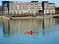
Del Monte Foods office building in the background
-
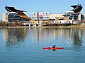
Heinz Field in the background
-
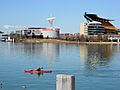
Heinz Field and Carnegie Science Center
-
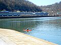
At the point


Nearby State Parks
Here are some other state parks within 30 miles (48 km) of Point State Park:
- Allegheny Islands State Park (Allegheny County)
- Hillman State Park (Washington County)
- Raccoon Creek State Park (Beaver County)
