Harmar Township, Allegheny County, Pennsylvania facts for kids
Quick facts for kids
Harmar Township, Pennsylvania
|
|
|---|---|
|
Township
|
|
| Motto(s):
In God We Trust
|
|

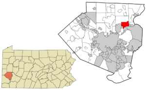
Location in Allegheny County and the state of Pennsylvania.
|
|
| Country | United States |
| State | Pennsylvania |
| County | Allegheny |
| Incorporated | 1875 |
| Founded by | Harmar Denny |
| Named for | Harmar Denny |
| Area | |
| • Total | 6.4 sq mi (17 km2) |
| • Land | 6.0 sq mi (16 km2) |
| • Water | 0.5 sq mi (1 km2) |
| Elevation | 761 ft (232 m) |
| Population
(2020)
|
|
| • Total | 3,136 |
| • Density | 490/sq mi (189.2/km2) |
| Time zone | UTC-5 (Eastern (EST)) |
| • Summer (DST) | UTC-4 (EDT) |
| ZIP codes |
15238, 15049, 15024
|
| Area code(s) | 412 and 724 |
| School district | Allegheny Valley School District |
Harmar Township is a small community in Allegheny County, Pennsylvania. It is a type of local government area called a township. In 2020, about 3,136 people lived here. Harmar Township was named after Harmar Denny, who was a U.S. congressman. He was the son of Ebenezer Denny.
Contents
Exploring Harmar Township
Harmar Township is located in a cool spot at 40°32′24″N 79°50′2″W / 40.54000°N 79.83389°W. It covers about 6.4 square miles. Most of this area is land, but about 0.5 square miles is water.
Rivers and Creeks
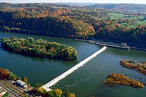
All the water in Harmar Township flows into the Allegheny River. This river is a big part of the area's natural beauty.
One special place here is Allegheny Islands State Park. This park is undeveloped and sits on three islands in the Allegheny River. It's a great spot to see nature.
Deer Creek also flows through the township. It joins the Allegheny River right in Harmar.
Nearby Places
Harmar Township shares its borders with several other towns and townships. These include Indiana Township to the north and Frazer Township to the northeast. To the east, you'll find Springdale Township and Cheswick.
To the southwest is O'Hara Township, and Fox Chapel is to the west. The township also sits along the Allegheny River. This means it's close to Oakmont to the south. You can even get to Oakmont using the Hulton Bridge. Plum is also nearby, to the south and southeast.
People of Harmar Township

In 2000, there were 3,242 people living in Harmar Township. These people lived in 1,522 homes. About 19.8% of these homes had kids under 18 living there. Many families were married couples living together.
The people in Harmar Township come from different backgrounds. Most residents were White. There were also smaller groups of African American, Native American, and Asian residents. A small number of people were Hispanic or Latino.
The average age of people in Harmar Township was 45 years old. About 17.1% of the population was under 18. About 22.5% were 65 or older.
Communities Within Harmar
Harmar Township includes a few smaller communities. These are:
- Acmetonia
- Harmarville
- Harmar Heights
- Chapel Downs
See also
 In Spanish: Municipio de Harmar para niños
 | Chris Smalls |
 | Fred Hampton |
 | Ralph Abernathy |


