
Clarion River facts for kids
Quick facts for kids Clarion River |
|
|---|---|

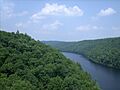
The Clarion River flows beneath I-80 (looking upstream).
|
|
| Country | United States |
| Physical characteristics | |
| Main source | 41°29′28″N 78°40′41″W / 41.4911727°N 78.6780816°W |
| River mouth | 850 ft (260 m) 41°06′59″N 79°40′30″W / 41.1164511°N 79.6750488°W |
| Basin features | |
| River system | Allegheny River |
| Type: | Scenic, Recreational |
| Designated: | October 19, 1996 |
The Clarion River is a long river in western Pennsylvania, United States. It flows into the Allegheny River. This river is about 110 miles (177 km) long. It runs through wild, forested areas of the Allegheny Plateau. The river's winding path goes through narrow valleys and thick hardwood forests.
Contents
Where the Clarion River Flows

The Clarion River starts in central Elk County. It forms where its East and West Branches meet near Johnsonburg. The East Branch is about 15 miles (24 km) long. It flows southwest through the East Branch Clarion River Lake.
The river generally flows west-southwest across western Pennsylvania. It has many tight bends and curves. It passes towns like Ridgway and Clarion. The Clarion River then joins the Allegheny River from the east. This meeting point is in western Clarion County. It is about 5 miles (8 km) south of Emlenton.
A part of the Clarion River is special. It is named a National Wild and Scenic River. This means it is protected for its natural beauty and value.
How Much Water Flows in the River?
The amount of water flowing in a river is called its discharge. This changes depending on the season and rainfall. Here are some average amounts of water that flow in different parts of the Clarion River system:
- The East Branch Clarion River near the East Branch Clarion River Dam has an average flow of about 148 cubic feet per second (4.2 cubic meters per second).
- The West Branch Clarion River near Wilcox has an average flow of about 128 cubic feet per second (3.6 cubic meters per second).
- Further downstream, the main Clarion River near St. Petersburg has a much larger average flow of about 2,248 cubic feet per second (63.7 cubic meters per second).
The History of the Clarion River
Before 1817, people often called the Clarion River "Tobeco." This name likely came from a Native American word. It meant "the stream that flows from a large spring." French explorers called it "Rivière au Fiel." Early settlers sometimes called it the Toby or Stump Creek.
The name Clarion was given in 1817 by a surveyor named Daniel Stanard. He said the sound of the water reminded him of a distant clarion. A clarion is a type of trumpet.
In the late 1800s and early 1900s, many trees were cut down. This happened in the area that is now the Allegheny National Forest. Trees were cut for the oil industry, which grew after Edwin Drake found oil in 1859. Wood was also used to make chemicals. Tree bark was in high demand for local tanneries. These tanneries made a lot of leather.
Cutting down so many trees caused problems. It led to more floods downstream, especially in Pittsburgh. Also, water runoff from tanneries and polluted water from old mines made the Clarion River very dirty. It became Pennsylvania's most polluted waterway.
Over time, the forests grew back. This helped the river heal. A big cleanup effort in the 1980s also made a huge difference. Today, the Clarion River is much cleaner. People use it for fishing, canoeing, and other fun outdoor activities. It flows through large areas of wildlife and forests.
In 1996, a 51.7-mile (83.2 km) part of the Clarion River was officially named a National Wild & Scenic River. This helps protect its natural beauty for everyone to enjoy.
Images for kids
-
The Clarion River flows beneath I-80 (looking upstream).
-
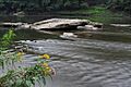
The Clarion River in Cook Forest State Park
