Chautauqua County, New York facts for kids
Quick facts for kids
Chautauqua County
|
|||
|---|---|---|---|

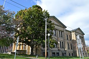
Chautauqua County Courthouse in Mayville
|
|||
|
|||

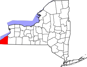
Location within the U.S. state of New York
|
|||
 New York's location within the U.S. |
|||
| Country | |||
| State | |||
| Founded | February 9, 1811 | ||
| Named for | Chautauqua Lake | ||
| Seat | Mayville | ||
| Largest city | Jamestown | ||
| Area | |||
| • Total | 1,500 sq mi (4,000 km2) | ||
| • Land | 1,060 sq mi (2,700 km2) | ||
| • Water | 440 sq mi (1,100 km2) 29% | ||
| Population
(2020)
|
|||
| • Total | 127,657 | ||
| • Density | 120.4/sq mi (46.5/km2) | ||
| Time zone | UTC−5 (Eastern) | ||
| • Summer (DST) | UTC−4 (EDT) | ||
| Congressional district | 23rd | ||
Chautauqua County is the westernmost county in the U.S. state of New York. As of the 2020 census, about 127,657 people live here. Its main town, called the county seat, is Mayville. The biggest city is Jamestown.
The name "Chautauqua" is thought to come from the Erie language. This language was lost long ago in the 1600s. We don't know exactly what the name means, but people have many ideas! The county was officially created in 1808 and started its own government in 1811. It's part of the Western New York area of the state.
Chautauqua County includes the cities of Jamestown, Dunkirk, and Fredonia. It is located southeast of Lake Erie. A small part of the Cattaraugus Reservation of the Seneca people is also in the county.
Contents
History of Chautauqua County
Before Europeans arrived, the Erie people lived in most of what is now Chautauqua County. This was before the Beaver Wars in the 1650s. French explorers started traveling through the area around 1615.
The Seneca Nation took control of the land during the Beaver Wars. They kept it for about 100 years. Later, the Seneca sided with the British against the American revolutionaries in the American Revolutionary War.
New York State officially created Chautauqua County on March 11, 1808. It was separated from Genesee County. At first, it was managed by Niagara County. Then, on February 9, 1811, Chautauqua County started its own separate government. The county has been the same size ever since. It covers about 1,100 square miles (2,800 square kilometers) of land.
In 1874, the first Chautauqua Assembly was started here. It was organized by a minister named John Heyl Vincent and a businessman named Lewis Miller. They held it at a camp on the shores of Chautauqua Lake.
Geography and Nature
Chautauqua County is in the very southwest corner of New York State. It is right along the border with Pennsylvania. It is the westernmost county in New York.
The county covers about 1,500 square miles (3,900 square kilometers) in total. About 1,060 square miles (2,700 square kilometers) is land, and 440 square miles (1,100 square kilometers) is water. This means about 29% of the county is water!
Chautauqua Lake is in the middle of the county. Lake Erie forms its northern border.
Water Flow and the Chautauqua Ridge
A special natural feature called the Eastern Continental Divide runs through Chautauqua County. This divide separates where water flows.
- Water that drains into Conewango Creek (including Chautauqua Lake) eventually flows all the way to the Gulf of Mexico.
- Water from the rest of the county flows into Lake Erie. From there, it goes through Lake Ontario and the St. Lawrence Seaway to the North Atlantic Ocean.
This divide is known as the Chautauqua Ridge. It helps mark the difference between the "North County" (near Dunkirk) and the "South County" (near Jamestown). These two areas sometimes have different interests.
The county has rolling hills and valleys. The land near Lake Erie is mostly flat and lower in elevation. The lowest point in the county is Lake Erie itself, at 571 feet (174 meters) above sea level. The highest point is Gurnsey Benchmark, at 2,180 feet (660 meters).
Neighboring Counties
Chautauqua County shares borders with these other counties:
- Erie County, New York - northeast
- Cattaraugus County, New York - east
- Warren County, Pennsylvania - southeast
- Erie County, Pennsylvania - southwest
It's interesting that Chautauqua County borders two counties named Erie County, but they are in different states!
Main Roads


 I-86 / NY 17 / Southern Tier Expressway
 Invalid type: I-Toll / New York Thruway
 US 20
US 20 US 62
US 62 NY 5
NY 5 NY 39
NY 39 NY 60
NY 60 NY 83
NY 83 NY 394
 NY 426
 NY 430
 NY 474
People and Population
| Historical population | |||
|---|---|---|---|
| Census | Pop. | %± | |
| 1820 | 12,568 | — | |
| 1830 | 34,671 | 175.9% | |
| 1840 | 47,975 | 38.4% | |
| 1850 | 50,493 | 5.2% | |
| 1860 | 58,422 | 15.7% | |
| 1870 | 59,327 | 1.5% | |
| 1880 | 65,342 | 10.1% | |
| 1890 | 75,202 | 15.1% | |
| 1900 | 88,314 | 17.4% | |
| 1910 | 105,126 | 19.0% | |
| 1920 | 115,348 | 9.7% | |
| 1930 | 126,457 | 9.6% | |
| 1940 | 123,580 | −2.3% | |
| 1950 | 135,189 | 9.4% | |
| 1960 | 145,377 | 7.5% | |
| 1970 | 147,305 | 1.3% | |
| 1980 | 146,925 | −0.3% | |
| 1990 | 141,895 | −3.4% | |
| 2000 | 139,750 | −1.5% | |
| 2010 | 134,905 | −3.5% | |
| 2020 | 127,657 | −5.4% | |
| U.S. Decennial Census 1790-1960 1900-1990 1990-2000 2010-2020 |
|||
Population in 2020
In 2020, the census showed that Chautauqua County had 127,657 people.
| Race | Num. | Perc. |
|---|---|---|
| White | 106,063 | 83.08% |
| Black or African American | 2,891 | 2.26% |
| Native American | 497 | 0.38% |
| Asian | 796 | 0.62% |
| Pacific Islander | 49 | 0.03% |
| Other/Mixed | 5,592 | 4.38% |
| Hispanic or Latino | 11,769 | 9.22% |
Education in Chautauqua County
There are several places to learn in Chautauqua County:
- Jamestown Community College has two campuses, one in Jamestown and one in Dunkirk.
- The State University of New York at Fredonia is in the northern part of the county.
- Jamestown Business College used to offer degrees and certificates in Jamestown.
Towns and Villages
Here are some of the main communities in Chautauqua County:
| # | Location | Population | Type | Area |
|---|---|---|---|---|
| 1 | Jamestown | 31,146 | City | Southeast |
| 2 | Dunkirk | 12,563 | City | Lake Shore |
| 3 | Fredonia | 11,230 | Village | Lake Shore |
| 4 | Westfield | 3,224 | Village | Lake Shore |
| 5 | Lakewood | 3,002 | Village | Southeast |
| 6 | Silver Creek | 2,656 | Village | Lake Shore |
| 7 | Falconer | 2,420 | Village | Southeast |
| 8 | Ripley | 2,415 | CDP | Lake Shore |
| 9 | Jamestown West | 2,408 | CDP | Southeast |
| 10 | Frewsburg | 1,906 | CDP | Southeast |
| 11 | †Mayville | 1,711 | Village | Southwest |
| 12 | Brocton | 1,486 | Village | Lake Shore |
| 13 | Celoron | 1,112 | Village | Southeast |
| 14 | Sherman | 730 | Village | Southwest |
| 15 | ††Forestville | 697 | Hamlet/CDP | Lake Shore |
| 16 | Sunset Bay | 660 | CDP | Lake Shore |
| 17 | Cassadaga | 634 | Village | Southeast |
| 18 | Sinclairville | 588 | Village | Center-East |
| 19 | Panama | 479 | Village | Southwest |
| 20 | Kennedy | 465 | CDP | Southeast |
| 21 | ††Cherry Creek | 461 | Hamlet/CDP | Center-East |
| 22 | Busti | 391 | CDP | Southeast |
| 23 | Bemus Point | 364 | Village | Southeast |
| 24 | Chautauqua | 191 | CDP | Southwest |
† - county seat (the main town for the county government)
†† - used to be a village
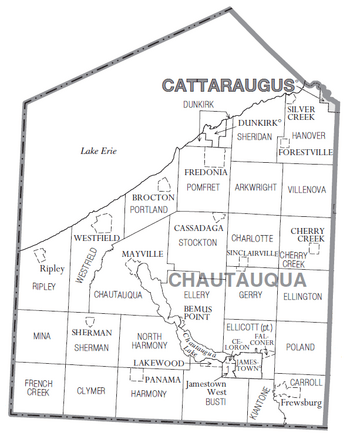
Towns in Chautauqua County
Other Small Communities (Hamlets)
- Ashville
- Findley Lake
- Forestville
- Hamlet
- Irving
- Laona
- Lily Dale
- Maple Springs
- Van Buren Bay
Indian Reservation
Unorganized Territory
See also
 In Spanish: Condado de Chautauqua (Nueva York) para niños


