
Erie County, New York facts for kids
Quick facts for kids
Erie County
|
|||
|---|---|---|---|
|
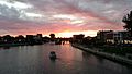
Left to right from top: Erie County Hall, Wendt Beach Park, Akron Falls Park, Chestnut Ridge Park, Canisius University, Gateway Park, Buffalo and Erie County Botanical Gardens
|
|||
|
|||

Location within the U.S. state of New York
|
|||
 New York's location within the U.S. |
|||
| Country | |||
| State | |||
| Founded | 1821 | ||
| Named for | Eriechronon | ||
| Seat | Buffalo | ||
| Largest city | Buffalo | ||
| Area | |||
| • Total | 1,227 sq mi (3,180 km2) | ||
| • Land | 1,043 sq mi (2,700 km2) | ||
| • Water | 184 sq mi (480 km2) 15% | ||
| Population
(2020)
|
|||
| • Total | 954,236 |
||
| • Density | 914.9/sq mi (353.2/km2) | ||
| Time zone | UTC−5 (Eastern) | ||
| • Summer (DST) | UTC−4 (EDT) | ||
| Congressional districts | 23rd, 26th | ||


.jpg)


Erie County is a county located in western New York State. It sits right on the shore of Lake Erie. In 2020, about 954,236 people lived here. The main city and county center is Buffalo. About 28% of the county's population lives in Buffalo.
Both the county and Lake Erie get their names from the Erie tribe. These Native Americans spoke an Iroquoian language. They lived in the area before 1654. Later, stronger Iroquoian tribes moved them out. Erie County is part of the Western New York region.
Erie County and its northern neighbor, Niagara County, form the Buffalo-Niagara Falls metropolitan area. This is the second largest city area in New York State. Only New York City is bigger. The southern part of the county is called the Southtowns. Erie County saw a lot of growth between 2010 and 2020. However, after the COVID-19 pandemic, the population has gone down a bit. Many businesses closed or moved to bigger cities.
Contents
History
When counties were first set up in New York in 1683, the Iroquois people lived in what is now Erie County. Many White Americans did not move here until after the American Revolutionary War ended in 1783. The United States made the Iroquois give up most of their land. This was because many Iroquois had helped the British during the war.
Around 1800, a group called the Holland Land Company bought a lot of land from New York State. This land makes up the eight western counties of New York today. The company surveyed the land, created towns, and started selling plots to people. New York State wanted more settlers and businesses to grow. At this time, all of western New York was part of Ontario County.
As more people moved in, the state created Genesee County in 1802. This was made from part of Ontario County. In 1808, Niagara County was created from Genesee County. Finally, in 1821, Erie County was formed from Niagara County. It included all the land between Tonawanda Creek and Cattaraugus Creek.
The first towns in Erie County were Clarence and Willink. Clarence is still a town today. But Willink was soon divided into other towns. When Erie County was created in 1821, it had towns like Amherst, Aurora, Boston, and Hamburg.
Many old houses and properties in the county are listed on the National Register of Historic Places listings in Erie County, New York. These places are important for their history.
In 1861, a small community called Town Line in the Town of Lancaster held a vote. They voted 85 to 40 to leave the Union. This was during the American Civil War. However, Town Line never actually joined the Confederate States of America. There is no proof that anyone from Town Line fought for the Confederacy. Some people at the time said the vote was just a joke. On January 24, 1946, Town Line officially voted to rejoin the Union. This event was reported all over the country.
Geography
Erie County covers about 1,227 square miles. About 1,043 square miles (85%) is land. The other 184 square miles (15%) is water.
The county is in the western part of upstate New York. It borders Lake Erie. It is the most populated county in upstate New York, outside of the New York City area. The county also sits on the border between the United States and Canada. It borders the Province of Ontario.
Tonawanda Creek forms the northern border of the county. Cattaraugus Creek forms part of the southern border. Other important streams include Buffalo River, Cayuga Creek, and Ellicott Creek.
The northern half of the county, including Buffalo, is called the Northtowns. This area is mostly flat and gently rises from the lake. The southern half, called the Southtowns, has more hills. It has the northwestern parts of the Appalachian Mountains. The highest point in the county is a hill in Sardinia. It is about 1,940 feet (591 meters) above sea level. The lowest point is about 560 feet (171 meters) on Grand Island.
Rivers, streams and lakes
Neighboring areas
- Niagara County - north
- Genesee County - northeast
- Wyoming County - southeast
- Cattaraugus County - south
- Chautauqua County - southwest
- Niagara Region, Ontario, Canada - northwest
Main roads

 Interstate 90 (New York State Thruway)
 Interstate 190 (Niagara Thruway)
 Interstate 290 (Youngmann Expressway)
 Interstate 990 (Lockport Expressway)
 U.S. Route 20
 U.S. Route 20A
 U.S. Route 62
 U.S. Route 219
 New York State Route 5
 New York State Route 16
 New York State Route 33
 New York State Route 39
 New York State Route 78
 New York State Route 179
 New York State Route 198
 New York State Route 263
 New York State Route 240
 New York State Route 277
 New York State Route 324
 New York State Route 354
 New York State Route 400
Protected natural areas
- Theodore Roosevelt Inaugural National Historic Site (a national park site)
State parks and preserves
- Amherst State Park
- Beaver Island State Park
- Buckhorn Island State Park
- Buffalo Harbor State Park
- Evangola State Park
- Great Baehre Swamp Wildlife Management Area
- Hampton Brook Woods Wildlife Management Area
- Knox Farm State Park
- Motor Island Wildlife Management Area
- Onondaga Escarpment Unique Area
- Reinstein Woods Nature Preserve
- Spicer Creek Wildlife Management Area
- Strawberry Island State Park
- Tillman Road Wildlife Management Area
- Woodlawn Beach State Park
- Zoar Valley Multiple Use Area
People and Population
| Historical population | |||
|---|---|---|---|
| Census | Pop. | %± | |
| 1830 | 35,719 | — | |
| 1840 | 62,465 | 74.9% | |
| 1850 | 100,993 | 61.7% | |
| 1860 | 141,971 | 40.6% | |
| 1870 | 178,699 | 25.9% | |
| 1880 | 219,884 | 23.0% | |
| 1890 | 322,981 | 46.9% | |
| 1900 | 433,686 | 34.3% | |
| 1910 | 528,985 | 22.0% | |
| 1920 | 634,688 | 20.0% | |
| 1930 | 762,408 | 20.1% | |
| 1940 | 798,377 | 4.7% | |
| 1950 | 899,238 | 12.6% | |
| 1960 | 1,064,688 | 18.4% | |
| 1970 | 1,113,491 | 4.6% | |
| 1980 | 1,015,472 | −8.8% | |
| 1990 | 968,532 | −4.6% | |
| 2000 | 950,265 | −1.9% | |
| 2010 | 919,040 | −3.3% | |
| 2020 | 954,236 | 3.8% | |
| 2022 (est.) | 950,312 | 3.4% | |
| U.S. Decennial Census 1790-1960 1900-1990 1990-2000 2010-2014 |
|||
In 2023, there were 954,236 people living in Erie County. The county has about 915 people per square mile. There are about 438,747 homes in the county.
Most people in the county are White (77.8%). About 13.9% are Black or African American. About 5.0% are Asian. People from two or more races make up 5.4%. About 6.4% of the population is Hispanic or Latino. Many people have German, Polish, Italian, or Irish family backgrounds. Most people (91.1%) speak English at home.

There were 380,873 households in the county. About 29.6% of these homes had children under 18 living there. The average household had 2.41 people. The average family had 3.04 people.
The population is spread out by age. About 24.3% are under 18. About 15.9% are 65 or older. The average age in the county is 38 years old.
The average income for a household was $38,567. For a family, it was $49,490. About 12.2% of all people in the county lived below the poverty line. This included 17.3% of those under 18.
2020 census
| Race | Num. | Perc. |
|---|---|---|
| White (NH) | 678,236 | 71% |
| Black or African American (NH) | 129,874 | 13.6% |
| Native American (NH) | 4,667 | 0.5% |
| Asian (NH) | 46,090 | 4.83% |
| Pacific Islander (NH) | 199 | 0.02% |
| Other/mixed (NH) | 35,512 | 3.72% |
| Hispanic or Latino | 59,658 | 6.25% |
Education
Erie County has many schools and colleges.
School districts
- Akron Central School District
- Alden Central School District
- Amherst Central School District
- Attica Central School District
- Buffalo City School District
- Cheektowaga Central School District
- Cheektowaga-Maryvale Union Free School District
- Cheektowaga-Sloan Union Free School District
- Clarence Central School District
- Cleveland Hill Union Free School District
- Depew Union Free School District
- East Aurora Union Free School District
- Eden Central School District
- Evans-Brant Central School District (Lake Shore) (also known as Lake Shore Central School District)
- Frontier Central School District
- Grand Island Central School District
- Gowanda Central School District
- Hamburg Central School District
- Holland Central School District
- Iroquois Central School District
- Kenmore-Tonawanda Union Free School District
- Lackawanna City School District
- Lancaster Central School District
- North Collins Central School District
- Orchard Park Central School District
- Springville-Griffith Institute Central School District
- Sweet Home Central School District
- Tonawanda City School District
- West Seneca Central School District
- Williamsville Central School District
- Yorkshire-Pioneer Central School District
Some special schools are also in the county. For example, Randolph Academy Union Free School District.
Colleges and Universities
- Buffalo State College
- Canisius College
- Daemen College
- D'Youville University
- Erie Community College
- Hilbert College
- Medaille College
- Trocaire College
- University at Buffalo
- Villa Maria College
- Bryant & Stratton College
Fun Things to Do
Erie County is home to several professional sports teams. These include the NFL's Buffalo Bills (football) and the NHL's Buffalo Sabres (hockey). You can also find the NLL's Buffalo Bandits (lacrosse). College sports are popular too, with the Division I Buffalo Bulls. For baseball fans, there are the MILB's Buffalo Bisons.
The city of Buffalo has many attractions. You can visit the Buffalo Zoo, The Buffalo History Museum, and the Buffalo and Erie County Botanical Gardens. There's also the Buffalo Museum of Science. You can explore tourist areas like Canalside and Larkinville.
The Erie County Fair is a huge event held every August in the Town of Hamburg. It's one of the biggest county fairs in the United States!
Erie County Parks
The Erie County Department of Parks, Recreation and Forestry started in 1925. It began with four parks. Today, the county manages 38 properties, covering about 11,000 acres of land. These parks offer places for fun and help protect nature and history.
Heritage parks

These are the five original county parks. They have beautiful scenery, nature, and historical features. Many buildings in these parks were built in the 1930s.
- Akron Falls Park
- Chestnut Ridge Park
- Como Lake Park
- Ellicott Creek Park
- Emery Park
Waterfront parks
These parks are along the shore of Lake Erie. They offer great views and trails.
- Bennett Beach Park
- Isle View Park
- Riverwalk Park
- Wendt Beach Park
Nature parks

These parks are mostly natural areas. They are managed to protect the environment. You can enjoy quiet outdoor activities here.
- Boston Forest
- Eighteen Mile Creek Park
- Franklin Gulf Park
- Scoby Dam Park
- Sgt. Mark A. Rademacher Memorial Park (also known as Hunters Creek Park)
Special parks
These parks have unique features for specific fun activities.
- Buffalo and Erie County Botanical Gardens
- Elma Meadows Golf Course
- Grover Cleveland Golf Course
- Sprague Brook Park
Forest areas
These areas are managed by the Erie County Bureau of Forestry. They include thousands of acres of trees, many planted in the 1930s. These forests are mostly in the southern part of the county. They offer trails for hiking. They also help protect natural resources.
Communities
| # | Location | Population (2010) | Type | Area |
|---|---|---|---|---|
| 1 | †Buffalo | 278,349 | City | Greater Buffalo |
| 2 | Cheektowaga | 75,178 | CDP | Greater Buffalo |
| 3 | Tonawanda | 58,144 | CDP | Greater Buffalo |
| 4 | West Seneca | 44,711 | CDP | Greater Buffalo |
| 5 | Lackawanna | 19,949 | City | Greater Buffalo |
| 6 | Kenmore | 15,423 | Village | Greater Buffalo |
| 7 | Depew | 15,303 | Village | Greater Buffalo |
| 8 | Tonawanda | 15,130 | City | Greater Buffalo |
| 9 | Eggertsville | 15,019 | CDP | Greater Buffalo |
| 10 | Lancaster | 10,352 | Village | Greater Buffalo |
| 11 | Hamburg | 9,409 | Village | Greater Buffalo |
| 12 | East Aurora | 6,236 | Village | Greater Buffalo |
| 13 | Harris Hill | 5,508 | CDP | Greater Buffalo |
| 14 | Williamsville | 5,300 | Village | Greater Buffalo |
| 15 | Grandyle Village | 4,629 | CDP | Greater Buffalo |
| 16 | Springville | 4,296 | Village | Southern |
| 17 | Lake Erie Beach | 3,872 | CDP | Southern |
| 18 | Sloan | 3,661 | Village | Greater Buffalo |
| 19 | Eden | 3,516 | CDP | Southern |
| 20 | Orchard Park | 3,246 | Village | Greater Buffalo |
| 21 | Wanakah | 3,199 | CDP | Greater Buffalo |
| 22 | Akron | 2,868 | Village | Northeast |
| 23 | ‡Gowanda | 2,709 | Village | Southern |
| 24 | Clarence | 2,646 | CDP | Greater Buffalo |
| 25 | Alden | 2,605 | Village | Northeast |
| 26 | Elma Center | 2,571 | CDP | Greater Buffalo |
| 27 | Blasdell | 2,553 | Village | Greater Buffalo |
| 28 | North Boston | 2,521 | CDP | Southern |
| 29 | Town Line | 2,367 | CDP | Northeast |
| 30 | Angola | 2,127 | Village | Southern |
| 31 | Billington Heights | 1,685 | CDP | Greater Buffalo |
| 32 | Angola on the Lake | 1,675 | CDP | Southern |
| 33 | North Collins | 1,232 | Village | Southern |
| 34 | Holland | 1,206 | CDP | Southern |
| 35 | Farnham | 386 | Village | Southern |
| - | Highland-on-the-Lake | N/A | CDP | Southern |
| - | University at Buffalo | N/A | CDP | Buffalo |
† - County seat
‡ - Not wholly in this county
Cities
Towns
Villages
- Akron
- Alden
- Angola
- Blasdell
- Depew
- East Aurora
- Farnham
- Hamburg
- Kenmore
- Lancaster
- North Collins
- Orchard Park
- Sloan
- Springville
- Williamsville
- Gowanda (partly located in Erie and Cattaraugus counties)

Hamlets
- Akron Junction
- Alden Center
- Armor
- Athol Springs
- Bagdad
- Bellevue
- Big Tree
- Blakeley
- Blossom
- Boston
- Bowmansville
- Brant
- Brighton
- Carnegie
- Chaffee
- Clarksburg
- Cleveland Hill
- Clifton Heights
- Collins Center
- Concord
- Creekside
- Crittenden
- Dellwood
- Derby
- Doyle
- Duells Corner
- Dutchtown
- East Amherst
- East Concord
- East Eden
- East Elma
- East Seneca
- Ebenezer
- Eden Valley
- Ellicott
- Elma
- Evans Center
- Ferry Village
- Footes
- Forks
- Fowlerville
- Gardenville
- Getzville
- Glenwood
- Green Acres
- Griffins Mills
- Holland
- Hunts Corners
- Jerusalem Corners
- Jewettville
- Kenilworth
- Lake View
- Langford
- Lawtons
- Locksley Park
- Looneyville
- Loveland
- Marilla
- Marshfield
- Millersport
- Millgrove
- Morton Corners
- Mount Vernon
- Murrays Corner
- New Ebenezer
- New Oregon
- North Bailey
- North Evans
- Oakfield
- Patchin
- Peters Corners
- Pine Hill
- Pinehurst
- Pontiac
- Porterville
- Protection
- Sand Hill
- Sandy Beach
- Scranton
- Sheenwater
- Shirley
- Snyder
- South Cheektowaga
- South Newstead
- South Wales
- Spring Brook
- Swifts Mills
- Swormville
- Taylor Hollow
- Town Line Station
- Walden Cliffs
- Wales Hollow
- Water Valley
- Webster Corners
- Wende
- West Alden
- West Falls
- Weyer
- Williston
- Windom
- Wolcottsburg
- Woodlawn
- Woodside
- Wyandale
- Zoar
Indian reservations
Images for kids
-

Erie County Hall
-
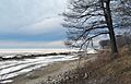
Wendt Beach Park
-
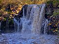
Akron Falls Park
-
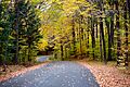
Chestnut Ridge Park
-
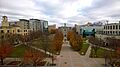
Canisius University
-
Gateway Park
-

Buffalo and Erie County Botanical Gardens
See also
 In Spanish: Condado de Erie (Nueva York) para niños
