Boston, New York facts for kids
Quick facts for kids
Boston
|
|
|---|---|
| Town of Boston | |

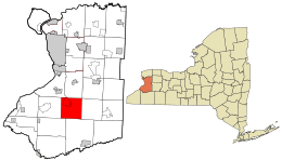
Location in Erie County and the state of New York.
|
|

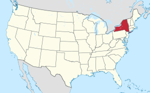
Location of New York in the United States
|
|
| Country | United States |
| State | New York |
| County | Erie County |
| Incorporated | 1817 |
| Named for | Boston, Massachusetts |
| Area | |
| • Total | 35.82 sq mi (92.78 km2) |
| • Land | 35.82 sq mi (92.78 km2) |
| • Water | 0.00 sq mi (0.00 km2) |
| Elevation | 925 ft (282 m) |
| Population
(2020)
|
|
| • Total | 7,948 |
| • Density | 225.01/sq mi (86.88/km2) |
| Time zone | UTC-5 (EST) |
| • Summer (DST) | UTC-4 (EDT) |
| ZIP code |
14025
|
| Area code(s) | 716 |
| FIPS code | 36-029-07454 |
Boston is a small town located in Erie County, New York, in the United States. In 2020, about 7,948 people lived there. The town got its name from the famous city of Boston, Massachusetts.
Boston is found inside Erie County. It is one of the "Southtowns" of the county. You can find Boston southeast of the larger city of Buffalo.
Contents
History of Boston, New York
Early Settlers and Town Formation
Long ago, the Iroquois people lived in this area. They were here for many years before European settlers arrived.
In 1804, two brothers, Charles and Oliver Johnson, moved here with their families. They were the very first settlers in the Boston area. Around 1811, the first Christian church, called the Free Will Baptist Church, was started.
The town of Boston was officially formed on April 5, 1817. It was created from a part of the nearby town of Eden. The first post office in Boston opened in 1832. It was located on the north side of town.
Health and Local Records
In 1843, the town faced a health challenge. Many people got sick with what was thought to be typhoid fever. This might have come from a local well. Out of 43 residents, 28 got sick, and 10 of them passed away.
You can find a lot of the town's history in the Maplewood Cemetery. This cemetery is across from the Boston Town Hall. Many old gravestones show the names of the first families who settled in the town.
Geography and Nature in Boston
Where is Boston Located?
The town of Boston covers an area of about 92.8 square kilometers (35.82 square miles).
From a geology point of view, Boston is quite interesting. Over many years, glaciers moved across the land. They pushed down with great force. This changed the landscape a lot. It even affected the water underground.
Main Roads and Waterways
Several important roads go through Boston. U.S. Route 219 crosses the town. Another important road is New York State Route 277. This road is also known as Boston State Road and Herman Hill Road. It meets New York State Route 391 (Boston State Road) in the northwestern part of town, near North Boston.
Eighteen Mile Creek is a stream that flows north through the town.
Population and People of Boston
How Many People Live Here?
| Historical population | |||
|---|---|---|---|
| Census | Pop. | %± | |
| 1820 | 686 | — | |
| 1830 | 1,520 | 121.6% | |
| 1840 | 1,745 | 14.8% | |
| 1850 | 1,872 | 7.3% | |
| 1860 | 1,716 | −8.3% | |
| 1870 | 1,633 | −4.8% | |
| 1880 | 1,617 | −1.0% | |
| 1890 | 1,278 | −21.0% | |
| 1900 | 1,398 | 9.4% | |
| 1910 | 1,535 | 9.8% | |
| 1920 | 1,325 | −13.7% | |
| 1930 | 1,368 | 3.2% | |
| 1940 | 1,710 | 25.0% | |
| 1950 | 2,302 | 34.6% | |
| 1960 | 5,106 | 121.8% | |
| 1970 | 7,158 | 40.2% | |
| 1980 | 7,687 | 7.4% | |
| 1990 | 7,445 | −3.1% | |
| 2000 | 7,897 | 6.1% | |
| 2010 | 8,023 | 1.6% | |
| 2020 | 7,948 | −0.9% | |
| U.S. Decennial Census | |||
In the year 2000, there were about 7,897 people living in Boston. They lived in almost 3,000 households. About 2,244 of these were families. The population density was about 220 people per square mile.
Many households had children under 18 living with them. Most households were married couples. The average household had about 2.63 people. The average family had about 3.06 people.
The population included people of all ages. About 25% were under 18 years old. About 12.7% were 65 years or older. The average age in Boston was 40 years old.
Places and Communities in Boston
- Boston (hamlet) – This is a small community in the southern part of the town. It is located on Boston State Road (NY-391). It used to be called "Boston Corners" or "Torrey Corners."
- Boston Forest County Park – This is a large natural area. It has about 700 acres of woods and open fields. It is in the southwestern part of the town.
- Creekside – You can find this spot near the northern border of the town. It is just north of North Boston.
- East Boston Hill – This area is located close to the eastern border of the town.
- North Boston – This is another small community. It is in the northwestern part of the town.
- Patchin – This community is near the center of the town. It is also on Boston State Road. It was once known as "Boston Center." It was named after an early resident, Talcott Patchin. He was a tanner and a postmaster.
- Ski Tamarack – This used to be a place for skiing. It is located in the northeastern part of the town.
Famous People from Boston
- Charles Miller – He was a military leader. His organization is now called the 28th Infantry Division. He also started the Galena-Signal Oil Company. This company later became part of Standard Oil and then Texaco.
- Joseph C. Sibley – He was a U.S. representative. He represented the state of Pennsylvania.
- A. Chapin Whiting – He was a member of the Wisconsin State Assembly.
- Ellen Beach Yaw – She was a very talented singer. She was known for her amazing vocal range.
See also
 In Spanish: Boston (Nueva York) para niños
 | William M. Jackson |
 | Juan E. Gilbert |
 | Neil deGrasse Tyson |

