Tonawanda (CDP), New York facts for kids
Quick facts for kids
Tonawanda, New York
|
|
|---|---|

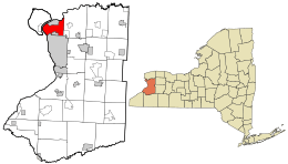
Location in Erie County and the state of New York
|
|
| Country | United States |
| State | New York |
| County | Erie |
| Town | Tonawanda |
| Area | |
| • Total | 18.6 sq mi (48.3 km2) |
| • Land | 17.3 sq mi (44.8 km2) |
| • Water | 1.4 sq mi (3.5 km2) |
| Elevation | 574 ft (175 m) |
| Population
(2020)
|
|
| • Total | 57,431 |
| • Density | 3,361/sq mi (1,297.7/km2) |
| Time zone | UTC-5 (Eastern (EST)) |
| • Summer (DST) | UTC-4 (EDT) |
| Area code(s) | 716 |
| FIPS code | 36-74183 |
| GNIS feature ID | 0967652 |
Tonawanda is a special kind of community called a census-designated place (CDP). It is located in Erie County, in the state of New York, United States. A CDP is an area that looks like a town but isn't officially a city or village.
The Tonawanda CDP includes most of the larger Town of Tonawanda. However, it does not include the nearby village of Kenmore. In 2010, about 58,144 people lived in the Tonawanda CDP.
Contents
Where is Tonawanda Located?
Tonawanda is found at specific geographic coordinates: 42.985307 degrees North and 78.852127 degrees West. These numbers help pinpoint its exact spot on a map.
How Big is Tonawanda?
According to the United States Census Bureau, the total area of Tonawanda is about 48.3 square kilometers (about 18.6 square miles). Most of this area, 44.8 square kilometers (17.3 square miles), is land. The remaining 3.5 square kilometers (1.4 square miles), which is about 7% of the total area, is covered by water.
Who Lives in Tonawanda?
The population of Tonawanda has changed over the years. Here's a quick look at how many people have lived there during different census counts:
| Historical population | |||
|---|---|---|---|
| Census | Pop. | %± | |
| 1980 | 72,795 | — | |
| 1990 | 65,284 | −10.3% | |
| 2000 | 61,729 | −5.4% | |
| 2010 | 58,144 | −5.8% | |
| 2020 | 57,431 | −1.2% | |
| source: | |||
Understanding the Population in 2000
In the year 2000, there were 61,729 people living in Tonawanda. These people lived in 26,207 different homes, and 16,929 of these were family households.
Most people in Tonawanda were White (about 95.74%). There were also smaller groups of people who identified as Black or African American, Native American, Asian, or from other backgrounds. About 1.30% of the population identified as Hispanic or Latino.
Homes and Families
Out of all the households in 2000, about 26.3% had children under 18 living there. More than half (51.2%) were married couples living together. About 10.3% were homes where a mother was raising children without a husband present.
The average number of people living in a household was about 2.33. For families, the average size was about 2.93 people.
Age Groups in Tonawanda
The population in Tonawanda in 2000 included people of all ages:
- About 21.5% were under 18 years old.
- About 7.2% were between 18 and 24 years old.
- About 26.6% were between 25 and 44 years old.
- About 22.7% were between 45 and 64 years old.
- About 22.1% were 65 years old or older.
The average age of people living in Tonawanda was 42 years old.
Income Levels
In 2000, the average income for a household in Tonawanda was $41,332. For families, the average income was $51,071. The average income per person in Tonawanda was $20,748.
About 7.3% of all people in Tonawanda lived below the poverty line. This included about 9.7% of those under 18 and 5.4% of those aged 65 or older.
Education in Tonawanda
Most of the Tonawanda CDP is served by the Kenmore-Tonawanda Union Free School District. This district provides public education for students in the area. A smaller part of Tonawanda is included in the Sweet Home Central School District.
See also
 In Spanish: Tonawanda (condado de Erie) para niños
 | May Edward Chinn |
 | Rebecca Cole |
 | Alexa Canady |
 | Dorothy Lavinia Brown |

