Lancaster (village), New York facts for kids
Quick facts for kids
Lancaster
|
|
|---|---|

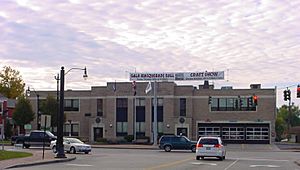
Lancaster Village Municipal Building
|
|

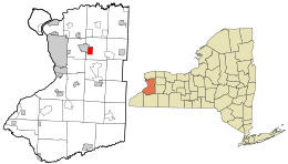
Location in Erie County and the state of New York
|
|
| Country | United States |
| State | New York |
| County | Erie |
| Town | Lancaster |
| Incorporated | 1849 |
| Named for | Lancaster, Massachusetts |
| Area | |
| • Total | 2.75 sq mi (7.13 km2) |
| • Land | 2.72 sq mi (7.04 km2) |
| • Water | 0.03 sq mi (0.09 km2) |
| Elevation | 673 ft (205 m) |
| Population
(2020)
|
|
| • Total | 10,027 |
| • Density | 3,689.11/sq mi (1,424.27/km2) |
| Time zone | UTC-5 (Eastern (EST)) |
| • Summer (DST) | UTC-4 (EDT) |
| ZIP codes |
14086
|
| Area code(s) | 716 |
| FIPS code | 36-41135 |
Lancaster is a charming village located in Erie County, New York, United States. It's a part of the larger Buffalo-Niagara Falls metropolitan area. In 2020, about 10,027 people called Lancaster home.
The village of Lancaster is in the western part of the town of Lancaster. It sits just east of the city of Buffalo. The Lancaster Opera House is a well-known spot for musicals and plays. The current mayor of Lancaster is Lynne T. Ruda.
Contents
Exploring Lancaster's Past
The Village of Lancaster was officially formed in 1849. It was created from a section of the larger town of Lancaster. This makes Lancaster the third oldest village in Erie County. Only Springville and Gowanda are older.
The village takes pride in its long history. It works hard to protect its old buildings. Lancaster was once known as "Cayuga Creek." It is one of about 30 places in New York with special historic districts.
Oldest Buildings and Churches
The oldest house in the village is the Carpenter–Draper House. It was built way back in 1831. The Lancaster Presbyterian Church is the second oldest church building in Erie County. It was built in 1832.
Many churches are found in the village. These include Lancaster Presbyterian Church, St. John's Lutheran, Trinity Episcopal, and Faith United Methodist. There are also Catholic churches like St. Mary of the Assumption and Our Lady of Pompeii.
The Famous Opera House
In 1894, the Lancaster Opera House was built. This large building with its clock tower is still a main feature of downtown Lancaster. The town offices are also inside this building. Because of this, people sometimes call it both the Opera House and Town Hall.
Downtown Area and Changes
The Central Avenue and Broadway area is the main business district in the village. West Main Street used to be another important business street. However, most of it was taken down in the early 1970s. Not many businesses are there today. Plans are in place to extend West Main Street again in the future.
Railroads and Trolleys
Four different railroads once passed through the village. Today, only two remain. Each railroad used to have a station on Central Avenue.
A trolley once traveled through the village as well. It came from Buffalo and went along several streets. The trolley then continued into the nearby village of Depew.
Fires and Historic Homes
Over the years, several fires have damaged the downtown area. The Great Fire of 1894 destroyed much of Central Avenue's west side. It also ruined the Grimes-Davis Mansion. A gas station now stands where the mansion once was.
Church Street, which is off Broadway, has many beautiful old homes. These houses have special architectural designs.
Early Immigrants to Lancaster
Lancaster's first immigrants were from the Netherlands. In the mid-1800s, many Germans arrived. They helped start St. Mary of the Assumption Catholic Church. Later, Italian immigrants moved to the village. They founded Our Lady of Pompeii Catholic Church.
St. John Neumann was a traveling priest in the mid-1800s. He visited churches around the Buffalo area. St. Mary of the Assumption Church was one of his stops. He helped a lot with building the church and its school.
Where is Lancaster Located?
Lancaster is located at 42°54′1″N 78°40′22″W / 42.90028°N 78.67278°W. It sits on Cayuga Creek and U.S. Route 20 (Broadway).
The village's northern edge is Walden Avenue. Walter Winter Road forms the eastern boundary. The southern edge is the northern border of the old Buffalo Creek Indian Reservation. Brunswick Road marks the western boundary.
The village covers about 7.1 square kilometers (2.75 square miles) in total. Most of this area, about 7.0 square kilometers (2.72 square miles), is land. A small part, about 0.1 square kilometers (0.03 square miles), is water.
Famous Historic Buildings
Many buildings in Lancaster are listed on the National Register of Historic Places listings in Erie County, New York. This means they are important historical sites. Some of these include:
- Bruce-Briggs Brick Block
- Clark-Lester House
- John Richardson House
- Lancaster Municipal Building
- Liebler-Rohl Gasoline Station
- Miller-Mackey House
- Dr. John J. Nowak House
- John P. Sommers House
- US Post Office-Lancaster
- Herman B. VanPeyma House
- Zuidema-Idsardi House
Places to Visit in Lancaster
Central Avenue and Broadway are the busiest streets in downtown Lancaster. You can find many shops and small stores there. This area is part of the Central Avenue Historic District.
Como Lake Park is a great place to gather in the village. The lighthouse in Como Lake Park, located on Cayuga Creek, is a popular spot for people of all ages.
Broadway also features many large, impressive houses and mansions. Many of these old homes have been turned into businesses or offices. Broadway is also home to several historic Protestant churches. This area is part of the Broadway Historic District.
St. Mary's Cemetery is a historic burial ground. It is located behind St. Mary of the Assumption Church.
The Lancaster Municipal Building is on Broadway. It holds all the village offices. One of the two village fire halls is also located here. The other fire hall is on W. Drullard Avenue.
Keysa Park has a public swimming pool. You can find it on Vandenburg Avenue.
Streets of Lancaster
Many streets in Lancaster are wide and lined with large, old trees. Broadway has some of the oldest trees. Burwell and Sawyer avenues are known as the widest residential streets.
A part of Central Avenue is lower than the surrounding land. This is because three railroad bridges are very close together there. Streets leading to Central Avenue have to slope downwards. The houses on Central Avenue are built above the street level.
Many of Lancaster's streets still have their original brick paving hidden beneath the asphalt.
Population and People
| Historical population | |||
|---|---|---|---|
| Census | Pop. | %± | |
| 1860 | 1,706 | — | |
| 1870 | 1,697 | −0.5% | |
| 1880 | 1,602 | −5.6% | |
| 1890 | 1,692 | 5.6% | |
| 1900 | 3,750 | 121.6% | |
| 1910 | 4,364 | 16.4% | |
| 1920 | 6,059 | 38.8% | |
| 1930 | 7,040 | 16.2% | |
| 1940 | 7,236 | 2.8% | |
| 1950 | 8,665 | 19.7% | |
| 1960 | 12,254 | 41.4% | |
| 1970 | 13,365 | 9.1% | |
| 1980 | 13,056 | −2.3% | |
| 1990 | 11,940 | −8.5% | |
| 2000 | 11,188 | −6.3% | |
| 2010 | 10,352 | −7.5% | |
| 2020 | 10,027 | −3.1% | |
| U.S. Decennial Census | |||
In 2000, there were 11,188 people living in Lancaster. The village had 4,726 households and 2,958 families. About 27.4% of households had children under 18. Around 49.3% were married couples.
The population was spread out by age. About 22.6% were under 18. About 17.8% were 65 or older. The average age in the village was 39 years.
Main Roads in Lancaster
 U.S. Route 20 (Broadway) is a major road that runs east to west through the village and town.
- New York State Route 952Q (Walden Ave.) is another important east-west road. It is the longest New York State Reference Route that is not a parkway.
Schools in the Village
Most of the village is part of the Lancaster Central School District. A small area in the southwest of the village is in the Depew Union Free School District.
See also
In Spanish: Lancaster (villa) para niños
 | Lonnie Johnson |
 | Granville Woods |
 | Lewis Howard Latimer |
 | James West |

