Lancaster, Massachusetts facts for kids
Quick facts for kids
Lancaster, Massachusetts
|
||
|---|---|---|
|
||
|
||
| Nickname(s):
Lancaster-on-the-Nashua
|
||
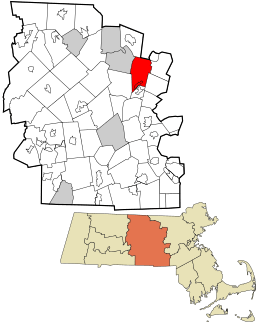
Location in Worcester County and the state of Massachusetts.
|
||
| Country | United States | |
| State | Massachusetts | |
| County | Worcester | |
| Settled | 1643 | |
| Incorporated | 1653 | |
| Government | ||
| • Type | Open town meeting | |
| Area | ||
| • Total | 28.2 sq mi (73.0 km2) | |
| • Land | 27.7 sq mi (71.8 km2) | |
| • Water | 0.5 sq mi (1.3 km2) | |
| Elevation | 300 ft (91 m) | |
| Population
(2020)
|
||
| • Total | 8,441 | |
| • Density | 299.3/sq mi (115.63/km2) | |
| Time zone | UTC−5 (Eastern) | |
| • Summer (DST) | UTC−4 (Eastern) | |
| ZIP Code |
01523
|
|
| Area code(s) | 351/978 | |
| FIPS code | 25-34165 | |
| GNIS feature ID | 0618368 | |
| Website | www.ci.lancaster.ma.us | |
Lancaster is a town in Worcester County, Massachusetts, United States. It was officially made a town in 1653. This makes Lancaster the oldest town in Worcester County. In 2020, about 8,441 people lived there.
Contents
History of Lancaster
Lancaster was first settled in 1643. It was called "Nashaway" after the local Nashaway Indian tribe. In 1653, it became an official town and was renamed "Lancaster on the Nashua."
How Lancaster Became the "Mothertown"
Lancaster is known as the "mothertown" of central Massachusetts. This is because many other towns were once part of Lancaster. Towns like Harvard, Bolton, Leominster, Clinton, Berlin, Sterling, and part of West Boylston all started as part of Lancaster.
Naming the Town
The founder of Lancaster was John Prescott. Some people wanted to name the new settlement Prescottville. However, the Massachusetts General Court (the state's legislature) thought it was too bold for a regular person to name a town after himself. At that time, not even a governor had done that. So, they decided to name the town Lancaster instead. This was the name of John Prescott's hometown in England.
The Story of Mary Rowlandson
In February 1676, during King Philip's War, a group of Native Americans attacked the town of Lancaster. They went through the town, and their last stop was Mary Rowlandson's house. Mary Rowlandson was a colonial woman who later wrote a famous book about her experiences.
During the attack, Mary's brother-in-law tried to defend the house but was killed. The attackers then set fire to the house, forcing Mary and her family to leave. Outside, many people from her household were killed. Mary, her son, and her two daughters were captured. They were taken on a long journey across New England. Mary was shot but survived. Sadly, her youngest daughter, Sarah, was injured and later died. Mary Rowlandson's book tells her amazing story of survival and eventual return.
Geography of Lancaster
Lancaster covers about 28.2 square miles (73.0 square kilometers). Most of this area, about 27.7 square miles (71.8 square kilometers), is land. The rest, about 0.5 square miles (1.3 square kilometers), is water.
Lancaster shares its borders with several other towns:
- To the north: Lunenburg and Shirley
- To the northeast: Harvard
- To the southeast: Bolton
- To the south: Clinton
- To the southwest: Sterling
- To the northwest: Leominster
People of Lancaster
| Historical population | ||
|---|---|---|
| Year | Pop. | ±% |
| 1850 | 1,688 | — |
| 1860 | 1,932 | +14.5% |
| 1870 | 1,845 | −4.5% |
| 1880 | 2,008 | +8.8% |
| 1890 | 2,201 | +9.6% |
| 1900 | 2,478 | +12.6% |
| 1910 | 2,564 | +3.5% |
| 1920 | 2,461 | −4.0% |
| 1930 | 2,897 | +17.7% |
| 1940 | 2,963 | +2.3% |
| 1950 | 3,601 | +21.5% |
| 1960 | 3,958 | +9.9% |
| 1970 | 6,095 | +54.0% |
| 1980 | 6,334 | +3.9% |
| 1990 | 6,661 | +5.2% |
| 2000 | 7,380 | +10.8% |
| 2010 | 8,055 | +9.1% |
| 2020 | 8,441 | +4.8% |
| 2023* | 8,802 | +4.3% |
| * = population estimate. Source: United States Census records and Population Estimates Program data. |
||
In 2010, there were 8,055 people living in Lancaster. There were 2,409 households and 1,758 families. The town had about 290.8 people per square mile.
Most of the people in Lancaster (86.4%) were White. About 7.7% were African American, and 1.7% were Asian. About 8.1% of the population identified as Hispanic or Latino.
The average household had 2.66 people, and the average family had 3.13 people. About 23.6% of the population was 19 years old or younger. The median age in Lancaster was 38.9 years.
In 2015, the average income for a household in Lancaster was about $96,813. For families, it was about $99,207. About 9.2% of the population lived below the poverty line. This included 17.1% of those under 18 years old.
Education in Lancaster
Lancaster is part of the Nashoba Regional School District. This district serves several towns in the area.
Lancaster is also home to some special schools:
- The former Atlantic Union College was located here.
- South Lancaster Academy was started in 1882–1883.
- The Dr. Franklin Perkins School is a private school for special education.
- Trivium School, founded in 1979, is a private Catholic college preparatory school. It is located on a historic estate.
Lancaster's Public Library
Lancaster has a public library called the Thayer Memorial Library. It first opened in 1868. In 2008, the town spent about $259,465 on its library. This was about $36 for each person in the town that year.
Notable People from Lancaster
Many interesting people have connections to Lancaster:
- Herman Vandenburg Ames: A dean at the University of Pennsylvania.
- Luther Burbank: A famous botanist and horticulturist who pioneered agricultural science.
- James C. Carter: A well-known lawyer from New York City.
- Charles F. Chandler: A chemist.
- Horace Cleveland: A landscape architect.
- Henrietta Swan Leavitt: An astronomer who made an important discovery about how bright Cepheid variable stars are.
- John Prescott: The pioneer who founded Lancaster.
- Mary Rowlandson: A colonial woman who was captured by Native Americans and wrote one of America's first best-selling books about her experience.
- Jared Sparks: A historian and president of Harvard University.
- Nathaniel Thayer (Jr.): A financier and philanthropist.
See also
 In Spanish: Lancaster (Massachusetts) para niños
 | Percy Lavon Julian |
 | Katherine Johnson |
 | George Washington Carver |
 | Annie Easley |


