Lunenburg, Massachusetts facts for kids
Quick facts for kids
Lunenburg, Massachusetts
|
||
|---|---|---|

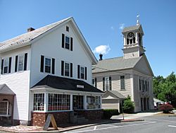
Lunenburg Town Hall
and Hadwen Park Market |
||
|
||

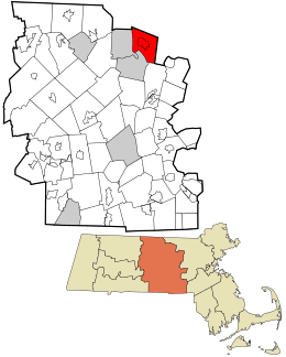
Location in Worcester County and the state of Massachusetts.
|
||
| Country | United States | |
| State | Massachusetts | |
| County | Worcester | |
| Settled | 1718 | |
| Incorporated | 1728 | |
| Government | ||
| • Type | Open town meeting and Board of Selectmen | |
| Area | ||
| • Total | 27.7 sq mi (71.7 km2) | |
| • Land | 26.4 sq mi (68.4 km2) | |
| • Water | 1.3 sq mi (3.3 km2) | |
| Elevation | 510 ft (155 m) | |
| Population
(2020)
|
||
| • Total | 11,782 | |
| • Density | 425.3/sq mi (164.32/km2) | |
| Time zone | UTC-5 (Eastern) | |
| • Summer (DST) | UTC-4 (Eastern) | |
| ZIP code |
01462
|
|
| Area code(s) | 351 / 978 | |
| FIPS code | 25-37420 | |
| GNIS feature ID | 0618370 | |
| Website | http://www.lunenburgma.gov/ | |
Lunenburg is a town in Worcester County, Massachusetts, United States. It is a place with a rich history and a growing community. In 2020, about 11,782 people lived here.
Contents
History of Lunenburg
Early Settlement and Name
Europeans first settled in Lunenburg in 1718. The town officially became a town in 1728. Its name comes from one of the titles of King George II of Great Britain. He was also known as the Duke of Brunswick-Lüneburg.
Challenges and Changes
During a conflict called King George's War (1744–1748), some Native American groups raided the village. They took settlers as captives to Quebec. This was a difficult time for the early residents.
Later, parts of nearby Fitchburg used to be part of Lunenburg. But around 1764, those settlers wanted their own town center. It was too far for them to walk to church and town meetings in Lunenburg. So, Fitchburg became its own separate town.
Whalom Park: A Fun Place
For many years in the 20th century, Whalom Park was a famous amusement park in Lunenburg. It was located on Whalom Lake. The park had a well-known roller coaster called the Flyer Comet. Sadly, the park closed in 2000. It could not compete with newer, bigger parks like Six Flags New England.
Geography of Lunenburg
Land and Water
Lunenburg covers a total area of about 27.7 square miles (71.7 km2). Most of this area, about 26.4 square miles (68.4 km2), is land. The rest, about 1.3 square miles (3.3 km2), is water. This means about 4.59% of the town is covered by water.
Neighboring Towns and Roads
Lunenburg shares its borders with several other towns. To the north is Townsend. To the east is Shirley. Lancaster is to the southeast. Leominster is to the south. Fitchburg is to the west. And Ashby is to the northwest.
Several main roads, called state highways, pass through Lunenburg. These include Route 2A, Route 13, and Route 225. These roads help people travel to and from Lunenburg.
Population of Lunenburg
| Historical population | ||
|---|---|---|
| Year | Pop. | ±% |
| 1900 | 1,332 | — |
| 1910 | 1,393 | +4.6% |
| 1920 | 1,634 | +17.3% |
| 1930 | 1,923 | +17.7% |
| 1940 | 2,195 | +14.1% |
| 1950 | 3,906 | +77.9% |
| 1960 | 6,334 | +62.2% |
| 1970 | 7,419 | +17.1% |
| 1980 | 8,405 | +13.3% |
| 1990 | 9,117 | +8.5% |
| 2000 | 9,401 | +3.1% |
| 2010 | 10,086 | +7.3% |
| 2020 | 11,782 | +16.8% |
| 2022* | 11,835 | +0.4% |
| * = population estimate. Source: United States Census records and Population Estimates Program data. |
||
In 2000, there were 9,401 people living in Lunenburg. This number has grown over the years. By 2020, the population reached 11,782 people. The town is home to many families. The average age of people in Lunenburg in 2000 was 39 years old. About 25.8% of the population was under 18 years old.
Education in Lunenburg
Public Schools
Lunenburg has several public schools for students. Younger students attend Lunenburg Primary School and Turkey Hill Elementary School. Older students go to Lunenburg Middle-High School. The middle and high schools are in the same building. It is located next to the Turkey Hill building.
Other Schools
There are also other school options. Applewild School is a private school nearby in Fitchburg. It teaches students from pre-school up to eighth grade. Lunenburg students can also attend Montachusett Regional Vocational Technical High School. This school offers technical and vocational training.
Transportation in Lunenburg
Getting around Lunenburg is possible in several ways. The Montachusett Regional Transit Authority helps elderly and disabled residents with special transportation services. Some parts of Lunenburg are also on its regular bus routes. For train travel, the closest stations are Shirley, Fitchburg, and North Leominster. These stations are on the MBTA Commuter Rail Fitchburg Line.
Notable People from Lunenburg
Many interesting people have connections to Lunenburg.
- Zabdiel Adams, a minister.
- William Austin, an author.
- George S. Boutwell, who was the Governor of Massachusetts and a U.S. Secretary of the Treasury.
- Asa Brigham, a politician involved in the Texas Revolution.
- Earle Brown, a composer.
- Luther Burbank, a famous botanist and agricultural scientist.
- Frederick Cushing Cross, Jr., a naval officer.
- Dominik Dijakovic, a professional wrestler.
- Gordon Edes, a baseball writer for ESPN.
- Derek Kerswill, a musician.
- Dorothea Leighton, a psychiatrist.
- Josiah Litch, a preacher.
- David Pelletier, a figure skater.
- James Reed, a soldier.
- Abel Stearns, a trader and cattle rancher.
- Asahel Stearns, a congressman.
- Eleazer D. Wood, an army officer.
- Dijak, another professional wrestler.
See also
 In Spanish: Lunenburg (Massachusetts) para niños
 | Laphonza Butler |
 | Daisy Bates |
 | Elizabeth Piper Ensley |


