
Shirley, Massachusetts facts for kids
Quick facts for kids
Shirley, Massachusetts
|
||
|---|---|---|

Old Shirley Municipal Building in 2008.
|
||
|
||

Location in Middlesex County in Massachusetts
|
||
| Country | United States | |
| State | Massachusetts | |
| County | Middlesex | |
| Settled | 1720 | |
| Incorporated | 1753 | |
| Government | ||
| • Type | Open town meeting | |
| Area | ||
| • Total | 15.9 sq mi (41.2 km2) | |
| • Land | 15.8 sq mi (41.0 km2) | |
| • Water | 0.1 sq mi (0.2 km2) | |
| Elevation | 279 ft (85 m) | |
| Population
(2020)
|
||
| • Total | 7,431 | |
| • Density | 467.4/sq mi (180.36/km2) | |
| Time zone | UTC-5 (Eastern) | |
| • Summer (DST) | UTC-4 (Eastern) | |
| ZIP code |
01464
|
|
| Area code(s) | 351 / 978 | |
| FIPS code | 25-61590 | |
| GNIS feature ID | 0618234 | |

Shirley is a town located in Middlesex County, Massachusetts, in the United States. It is about thirty miles northwest of Boston. In 2020, the town had a population of 7,431 people. Shirley is known for its historic town center, which has been well-preserved over the years.
The town is also home to a state correctional facility. Inside the grounds of this facility, you can find the remains of an old Shaker village.
Contents
A Look Back: Shirley's History

Long ago, the area now known as Shirley was home to the Nipmuc (or Pennacook) Native American people. They called this land Catacunemaug. English settlers first arrived around 1720. At that time, Shirley was part of a larger area called "The Plantation of Groton."
In 1753, Shirley became its own town, separating from Groton. It was named after William Shirley, who was the governor of Massachusetts from 1741 to 1757. The town quickly grew with new businesses. A paper mill was built around 1790, and the first of seven cotton mills opened in 1812. Other things made in Shirley included iron, nails, fabrics, rope, belts, suspenders, and sports gear. Today, two of the big 19th-century mill buildings are used by modern businesses.
The Shaker Village in Shirley

A special religious community called the Shirley Shaker Village was started in Shirley in 1793. The Shakers were a group of people who believed in living peacefully, sharing everything, and living in communal groups. They were famous for their simple and beautiful furniture and buildings.
The Shaker movement was most popular in the 1840s. However, over time, fewer people joined. This might have been because of new job chances during the Industrial Revolution. Also, younger generations might have found the Shaker way of life too strict. The Shirley Shaker Village closed its doors in 1908.
Today, a state correctional facility is built on the land where the Shaker village once stood. The town also has a Senior Center at 9 Parker Road, which used to be a school for young children.
Shirley's Geography
Shirley covers a total area of about 15.9 square miles (41.2 square kilometers). Most of this area, 15.8 square miles (41.0 square kilometers), is land. Only a small part, 0.1 square mile (0.2 square kilometers), is water.
The town is bordered by the Squannacook and Nashua rivers. It also has smaller streams like Mulpus Brook and Catecunemaug Brook. Important wetland areas include Spruce Swamp and Tophet Swamp.
Population and People
Shirley has seen its population grow over the years. In 1850, there were 1,158 people living in the town. By 1950, the population had grown to 4,271. The most recent count in 2020 showed 7,431 people living in Shirley.
Schools in Shirley
Shirley is part of a regional school system with the nearby town of Ayer. This system officially started in 2011.
- Lura A. White Elementary School
- Ayer Shirley Regional Middle School
- Ayer Shirley Regional High School
Parks and Fun Places
Shirley has several parks and outdoor areas where you can enjoy nature and recreation.
- Benjamin Hill Recreation Area
- Fredonian Nature Center
- Whitley Park
- Farandnear Reservation
Interesting Places to Visit
There are many interesting spots to explore in Shirley:
- Shirley Historical Society Museum: Learn about the town's past.
- Shirley Shaker Village: See the remains of the historic Shaker community.
- Shirley Senior Center: A community hub for older residents.
- Shirley Meeting House: A historic building used for gatherings.
- Storybook Cottage: A unique house with fun storybook figures and signs. This special place was created by Dave Holden and artist Tom Fleming.
- Hazen Memorial Library: The town's public library.
Getting Around: Transportation
You can travel to and from Shirley by train. The MBTA provides commuter rail service from Boston's North Station. There is a train stop in Shirley on the Fitchburg Line. For elderly and disabled residents, the Montachusett Regional Transit Authority (MART) offers special transportation services.
News and Media
Shirley has local newspapers and a public access television channel.
Newspapers
- Nashoba Valley Voice (used to be called Shirley Oracle)
- Fitchburg Sentinel & Enterprise
- The Lowell Sun
- Worcester Telegram & Gazette
Cable
- Shirley Public Access Corporation
Famous People from Shirley
Many notable people have connections to Shirley:
- Simon Atherton: A Shaker leader.
- Clara Bancroft Beatley: An educator, speaker, and writer.
- Oliver Holden: A person who wrote hymns.
- Benton MacKaye: A forester who suggested creating the famous Appalachian Trail.
- Sarah Carter Edgarton Mayo: A writer and editor.
- Daniel Parker: A general who held important government roles.
- Earl Tupper: The person who started the Tupperware company.
- Jerry White: A former professional baseball player.
Images for kids
-
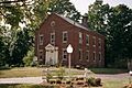
Old Shirley Municipal Building in 2008.
-
The official seal of Shirley, Massachusetts.
-
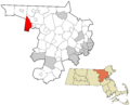
A map showing Shirley's location in Middlesex County.
See also
 In Spanish: Shirley (Massachusetts) para niños
