Nashua River facts for kids
Quick facts for kids Nashua River |
|
|---|---|

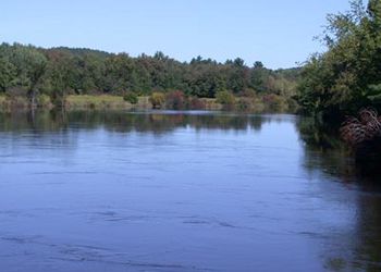
Nashua River, just outside Groton, Massachusetts
|
|
| Country | United States |
| States | Massachusetts, New Hampshire |
| Counties | Middlesex, MA Hillsborough, NH |
| Towns and cities | Lancaster, Shirley, Ayer, Groton, Pepperell (MA), Hollis, Nashua (NH) |
| Physical characteristics | |
| Main source | Confluence of North Nashua River and South Nashua River Lancaster, MA 233 feet (71 m) 42°26′50″N 71°40′9″W / 42.44722°N 71.66917°W |
| River mouth | Merrimack River Nashua, NH 95 feet (29 m) 42°45′58″N 71°26′49″W / 42.76611°N 71.44694°W |
| Length | 37.5 mi (60.4 km) |
| Basin features | |
| Basin size | 108 square miles (280 km2) |
| Tributaries |
|
| Type: | Scenic |
| Designated: | March 12, 2019 |
The Nashua River is a beautiful river, about 37.5 miles (60.4 km) long. It flows through parts of Massachusetts and New Hampshire in the United States. This river is a major branch of the Merrimack River.
The Nashua River starts in eastern Worcester County, Massachusetts. It forms where two smaller rivers, the North Nashua River and the South Nashua River, meet. From there, it flows generally north-northeast. It passes towns like Groton before joining the Merrimack River in Nashua, New Hampshire. The area drained by the Nashua River, called its watershed, covers a large part of north-central Massachusetts and a smaller part of southern New Hampshire.
The North Nashua River begins west of Fitchburg and Westminster. It flows about 30 miles (48 km) southeast past Fitchburg. It then joins the South Nashua River. The South Nashua River is considered the main part of the Nashua River.
Contents
History of the Nashua River
The name "Nashua" comes from an Algonkian word. It means "beautiful river with a pebbly bottom."
Early Industry and Pollution
For a long time, the Nashua River was very important for local industries. This was especially true during the colonial period and the early years of the United States. In the late 1700s and early 1800s, many paper mills were built along the river. These mills, especially near Fitchburg, used a lot of dyes. Sadly, this led to a lot of pollution. The river downstream from the factories often turned different colors because of the waste.
Cleaning Up the River
In the mid-1960s, a determined woman named Marion Stoddart started a big effort. She wanted to clean up the Nashua River and its smaller streams. Marion worked with many different groups, including business leaders and even the paper companies that were causing the pollution.
With help from the federal government, eight water treatment plants were built or improved along the river. These plants helped clean the water before it went back into the river. Also, a wide protected area was created along about half of the river and its two main branches. By the early 1990s, most industries were still along the river. However, many parts of the river were clean enough for swimming again! Marion Stoddart's amazing work is shown in a documentary movie called Marion Stoddart: Work of 1000.
River Recovery and Recreation
Thanks to these cleanup efforts, the river became much healthier. This recovery has led to more people using the river for fun activities. Places like Mine Falls Park in Nashua are now popular for recreation.
Today, the Nashua River Watershed Association helps watch over the river's condition. This group is mostly made up of volunteers and is based in Groton, Massachusetts.
In 2013, a special law was passed. It named 27 miles (43 km) of the Nashua River as a National Wild and Scenic River. This means it's protected for its natural beauty and importance. This law was supported by the Nashua River Watershed Association and The Wilderness Society.
Nashua River Watershed
A watershed is an area of land where all the water drains into a single river or body of water. The Nashua River watershed is quite large!
The South Nashua River starts from the Wachusett Reservoir in Clinton, Massachusetts. It flows north and meets the North Nashua River in Lancaster. The North Nashua River flows southeast from Fitchburg and Leominster to Lancaster.
From Lancaster, the Nashua River flows north. It winds through towns like Harvard, Groton, Dunstable, and Pepperell. Finally, it empties into the Merrimack River at Nashua, New Hampshire.
The entire Nashua River watershed covers about 538 square miles (1,390 km²). About 454 square miles (1,176 km²) are in Massachusetts, and 74 square miles (192 km²) are in New Hampshire. The Nashua River itself flows for about 56 miles (90 km). About 46 of those miles (74 km) are in Massachusetts.
Many smaller rivers and streams feed into the Nashua River. These include the Squannacook, Nissitissit, Stillwater, Quinapoxet, North Nashua, and South Nashua rivers. The watershed includes parts of 31 communities. Seven of these are in southern New Hampshire, and 24 are in central Massachusetts. The biggest water body in the watershed is the Wachusett Reservoir. This reservoir provides drinking water to two-thirds of Massachusetts' population!
Important Parts of the Watershed
- The Wachusett Reservoir is the largest body of water in the watershed.
- The Stillwater River flows into the Wachusett Reservoir from the northwest.
- The Quinapoxet River also feeds the Wachusett Reservoir from the west.
- The Wachusett Reservoir Dam holds back the South Nashua River.
- The North Nashua River joins the South Nashua River at Lancaster.
- The Squannacook River joins the Nashua River where the towns of Shirley, Groton, and Ayer meet.
- The Nissitissit River joins the Nashua River at Pepperell.
Images for kids
-
Nashua River, just outside Groton, Massachusetts
See also
 | Emma Amos |
 | Edward Mitchell Bannister |
 | Larry D. Alexander |
 | Ernie Barnes |


