
Quinapoxet River facts for kids
Quick facts for kids Quinapoxet River |
|
|---|---|

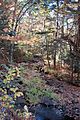
View from Princeton Road in Holden
|
|
| Physical characteristics | |
| Main source | Princeton, Massachusetts 802 ft (244 m) 42°23′46″N 71°52′59″W / 42.396°N 71.883°W |
| River mouth | Wachusett Reservoir 384 ft (117 m) 42°23′06″N 71°47′49″W / 42.385°N 71.797°W |
| Length | 7.9 miles (12.7 km) |
| Basin features | |
| Basin size | 57 sq mi (150 km2) |
| Tributaries |
|
The Quinapoxet River is a river in northern Massachusetts, United States. It is part of the Nashua River watershed. This river is very important because it helps supply drinking water to the greater Boston area. It is managed by the Massachusetts Water Resources Authority.
Contents
Where Does the Quinapoxet River Start?
The Quinapoxet River begins in the town of Princeton, Massachusetts. This area is known as the Upper Worcester Plateau. It is also called the Monadnock Upland. The highest point in this area is Mount Wachusett.
Water from this high ground flows in different directions. Water flowing east feeds the Nashua River watershed. Water flowing west goes to the Ware River or the Millers River watersheds. These rivers eventually lead to the Connecticut River.
The Quinapoxet Dam
The Quinapoxet Dam is located in Holden, Massachusetts. This dam creates the Quinapoxet Reservoir. The reservoir holds about 1.1 billion US gallons of water. This water is used as a drinking water supply for Worcester.
Below the dam, the Quinapoxet River flows about 7.9 miles (12.7 km) east. It eventually reaches the Wachusett Reservoir. Here, it joins the Stillwater River. Together, they form the south branch of the Nashua River. This happens in the Oakdale part of West Boylston.
The city of Worcester can use up to 36% of the Quinapoxet River's water. The Quinapoxet Dam is made of earth with a concrete spillway. The amount of water flowing out cannot be changed. This means the reservoir only sends extra water to the Quinapoxet River.
The Wachusett Reservoir: A Key Water Source
The Quinapoxet and Stillwater rivers are the two main rivers that flow into the Wachusett Reservoir. This reservoir is the main source of water for 2.5 million people. These people live in 43 communities across central and eastern Massachusetts.
To keep the water clean, the United States Geological Survey works with the Massachusetts Department of Conservation and Recreation. They have special equipment to measure the flow of water near where both rivers enter the reservoir. This constant monitoring helps make sure the water in the reservoir stays high quality. The water from these rivers has been very clean for many years.
Protecting the River's Land
About 35% of the land around the Quinapoxet River is protected. This includes the surface water of the Worcester reservoirs. The City of Worcester owns the land right around its reservoirs. It also owns about 25% of the entire area that collects water for its supply. This land is a highly protected forest. People are not allowed to enter it.
The Massachusetts Water Resources Authority (MWRA) also owns a lot of land here. The Town of Holden owns over 600 acres (2.4 km²) as the Trout Brook Conservation Area. The Massachusetts Audubon Society owns hundreds of acres in the Wachusett Meadow Wildlife Sanctuary. There are other protected areas in this region too.
River Health and Quality
The lower part of the Quinapoxet River is watched closely for its biology, chemistry, and water flow. Chaffins Brook, a smaller stream, has some pollution. Its lower section has unwanted aquatic plants in a ponded area.
Trout Brook in Holden is considered to have very good habitat. It has not been disturbed much by human activity. There are also several areas around Holden center where a lot of groundwater can be found. To protect this important water source, the town has passed a special law called an aquifer protection bylaw.
Images for kids
-
The headwaters of the Quinapoxet River

