
Princeton, Massachusetts facts for kids
Quick facts for kids
Princeton, Massachusetts
|
|||
|---|---|---|---|

Town Common in Princeton, MA
|
|||
|
|||

Location in Worcester County and the state of Massachusetts.
|
|||
| Country | United States | ||
| State | Massachusetts | ||
| County | Worcester | ||
| Settled | 1743 | ||
| Incorporated | 1771 | ||
| Government | |||
| • Type | Open town meeting | ||
| Area | |||
| • Total | 35.8 sq mi (92.8 km2) | ||
| • Land | 35.4 sq mi (91.8 km2) | ||
| • Water | 0.4 sq mi (1.0 km2) | ||
| Elevation | 1,175 ft (358 m) | ||
| Population
(2020)
|
|||
| • Total | 3,495 | ||
| • Density | 97.63/sq mi (37.662/km2) | ||
| Time zone | UTC−5 (Eastern) | ||
| • Summer (DST) | UTC−4 (Eastern) | ||
| ZIP Code |
01541
|
||
| Area code(s) | 351/978 | ||
| FIPS code | 25-55395 | ||
| GNIS feature ID | 0618380 | ||
| Website | town.princeton.ma.us | ||


Princeton is a town in Worcester County, Massachusetts, in the United States. It is surrounded by other towns like Sterling, Leominster, and Westminster.
A very important place in Princeton is Mount Wachusett. This mountain is partly in Princeton and partly in Westminster. But you can enter it from Princeton.
Long ago, in 1675, a woman named Mary Rowlandson was set free at a place called Redemption Rock. This rock is now in Princeton. She was released by a Native American leader named King Philip.
In 2020, about 3,495 people lived in Princeton. It is a quiet, rural town. Many people who live here travel to nearby cities for work. These cities include Worcester, Gardner, and Boston.
Contents
History of Princeton
Early Days and Name
In 1676, during a conflict called King Philip's War, Native Americans brought a captive named Mary Rowlandson to Princeton. They released her to the colonists at Redemption Rock.
The town of Princeton officially became a town in 1759. Before that, its land was part of Rutland. The town was named after a person called Reverend Thomas Prince.
Over the years, Princeton grew. In 1810, it added a piece of land from Hubbardston. Later, in 1870, it added another piece from Westminster.
Historic Places to Visit
Princeton has five places listed on the National Register of Historic Places. These are special places that are kept safe because of their history.
- East Princeton Village Historic District: This area is along Main Street and Leominster Road. It was added to the list in 2004.
- Fernside-Vacation House for Working Girls: This house is at 162 Mountain Road. It was added in 2002.
- Princeton Center Historic District: This area is where Hubbardston and Mountain Roads meet. It was added in 1999.
- Russell Corner Historic District: This district includes Merriam, Gregory Hill, East Princeton, and Sterling Roads, plus Bullock Lane. It was added in 2006.
- West Village Historic District: This area is where Allen Hill and Hubbardston Roads meet.
-
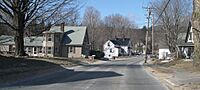
East Princeton Village Historic District along Route 140
-
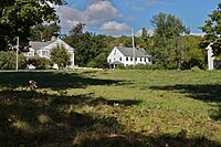
West Village Historic District
-
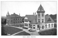
Princeton Public Library at right and Bagg Hall (town hall) at left, 1899
-
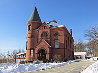
Bagg Hall, the town hall of Princeton


Geography of Princeton
Princeton covers a total area of about 35.8 square miles (92.8 square kilometers). Most of this area, about 35.4 square miles (91.8 square kilometers), is land. The rest, about 0.4 square miles (1.0 square kilometer), is water.
People of Princeton
| Historical population | ||
|---|---|---|
| Year | Pop. | ±% |
| 1850 | 1,318 | — |
| 1860 | 1,201 | −8.9% |
| 1870 | 1,279 | +6.5% |
| 1880 | 1,100 | −14.0% |
| 1890 | 982 | −10.7% |
| 1900 | 975 | −0.7% |
| 1910 | 818 | −16.1% |
| 1920 | 682 | −16.6% |
| 1930 | 717 | +5.1% |
| 1940 | 713 | −0.6% |
| 1950 | 1,032 | +44.7% |
| 1960 | 1,360 | +31.8% |
| 1970 | 1,681 | +23.6% |
| 1980 | 2,425 | +44.3% |
| 1990 | 3,189 | +31.5% |
| 2000 | 3,353 | +5.1% |
| 2010 | 3,413 | +1.8% |
| 2020 | 3,495 | +2.4% |
| 2022* | 3,504 | +0.3% |
| * = population estimate. Source: United States Census records and Population Estimates Program data. |
||
In 2000, there were 3,353 people living in Princeton. There were 1,166 households, and 959 families. The town had about 94.6 people per square mile.
Many households, about 41.9%, had children under 18 living with them. Most households, 74.7%, were married couples.
The people in Princeton were spread out by age. About 28.9% were under 18 years old. The average age was 40 years. For every 100 females, there were about 102 males.
The average income for a family in Princeton was about $152,884 per year.
Education in Princeton
Schools for Students
Princeton is part of the Wachusett Regional School District.
- The Thomas Prince School is for younger students. It teaches children from kindergarten up to 8th grade.
- For high school, students can go to Wachusett Regional High School in Holden, MA. This is a traditional public high school.
- Another option is the Montachusett Regional Vocational Technical School in Fitchburg, MA. This school teaches job skills and trades.
College and Library
- Princeton is also served by Mount Wachusett Community College. Its main campus is in Gardner, Massachusetts.
- The Princeton Public Library opened in 1884. It helps people in the town learn and read.
Fun Places to Visit

- Cornerstone Ranchers
- Harrington Farm
- Mount Wachusett
- Princeton Historical Society
- Wachusett Meadow Wildlife Sanctuary
- Wachusett Mountain Ski Area
- Wachusett Mountain State Reservation
- Redemption Rock
- Hubbard farm
Famous People from Princeton
- Daniel Davis Jr. (1813–1887) - He was an inventor.
- Ward Nicholas Boylston (1747–1828) - He was a kind person who gave money to the town. He helped the church, its minister, and supported widows and orphans.
- Moses Gill (1734–1800) - He was a lieutenant governor and acting governor of Massachusetts.
- Louise H. Gregory (1880–1954) - She was a professor who studied animals at Barnard College.
- Ruth Ellen Grout (1901–1998) - She was a professor of health education at the University of Minnesota.
- Ezra Heywood (1829–1893) - He was a person who fought for freedom and women's rights.
- Edward Savage (1761–1817) - He was an artist who painted portraits and owned an early museum.
See also
 In Spanish: Princeton (Massachusetts) para niños
