
Millers River facts for kids
Quick facts for kids Millers River |
|
|---|---|

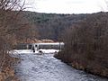
Millers River at Athol, Massachusetts
|
|
| Physical characteristics | |
| Main source | Confluence of Bear Meadow Brook and Bluefield Brook, Ashburnham, Massachusetts 1,124 feet (343 m) |
| River mouth | Connecticut River at Millers Falls, Massachusetts 175 feet (53 m) |
| Length | 52 miles (84 km) |
| Basin features | |
| Basin size | 390 square miles (1,000 km2) |
The Millers River is a 52.1-mile (83.8 km) long river in northern Massachusetts. It starts in Ashburnham and flows into the Connecticut River near Millers Falls, Massachusetts. People enjoy using parts of the river for exciting whitewater kayaking. Other sections are great for flatwater canoe races. The river is also a popular spot for fishing, especially for pike.
Contents
Discover the Millers River's Old Names
Long ago, Native American tribes had their own names for the Millers River.
What Does Papacontuckquash Mean?
The Nipmuc people called the river Papacontuckquash. This name means "split banks river." It comes from their words papahe (split), akun (bank), tekw (river), and esh (a plural ending). This name was written on old land deeds for Hampshire County. It also appeared on an ancient map at Williams College. A 17th-century Pocomtuc leader named Sonskqua Mishalisk also used the name Papcontuckquash for the river.
Why Was It Also Called Paquag?
Some people thought the river was called "Paquag," "Baqaug," or "Pacquoag." However, "Paquoag" actually referred to the area where the town of Athol is today. In 1932, a leader named Kchisogmo Henry Lorne Masta confirmed this. He said Pakwaik meant "arrows place." This was because of the arrowwood plants (Viburnum dentatum) that grew there. People used these plants to make arrow shafts.
Where the Millers River Flows
The Millers River collects water from a large area called a watershed. This watershed covers about 390 square miles (1,000 km2). Most of this area, about 313 square miles (810 km2), is in Massachusetts. The rest is in New Hampshire.
What the Land Looks Like
About 78 percent of the land in the river's watershed is covered by forests. Another 11 percent is open land, and 8 percent is wetland. Only 3 percent of the area has towns and cities. The watershed includes parts of 17 different towns. About 87,000 people live in this area. The main towns in the watershed are Winchendon, Gardner, Athol, and Orange.
Lakes and Ponds in the Watershed
Many wetlands in the area show where shallow lakes and ponds used to be. Over time, these areas slowly filled in. There are 107 lakes and ponds in the watershed. Seventy-two of these are 10 acres (40,000 m2) or larger. Only one lake, Lake Monomonac, is bigger than 500 acres (2.0 km2). Lake Monomonac is 592 acres (2.40 km2) and is located in Winchendon, Massachusetts and Rindge, New Hampshire.
How the Millers River Began

The Millers River was formed a long, long time ago. This happened at the end of the last Ice Age. Several large glacial lakes joined together. Eventually, their water drained into the Connecticut River, creating the Millers River. The main start of the river is in Ashburnham, Massachusetts. The North Branch of the river begins in Mountain Pond. This pond is at the western base of the Wapack Range in New Ipswich, New Hampshire.
River Path and Connecting Streams
The North Branch and the main part of the Millers River meet in Winchendon. From there, the river flows west until it reaches the Connecticut River.
Important Tributaries of the River
Several smaller rivers and streams, called tributaries, flow into the Millers River.
- Tarbell Brook joins the river about two miles west of Winchendon Center.
- The Otter River flows into the Millers River in Winchendon, within the Otter River State Forest.
- The Tully River joins the Millers River in Athol.
These tributaries mostly flow through wetlands.
How Steep is the River?
Overall, the Millers River has a moderate slope. It drops about 18 feet for every mile it travels from its start to the measuring station at Erving. This distance is about 43 miles (69 km).
However, there's a 5-mile (8.0 km) section of the river between South Royalston and Athol. This area is called the "Bear's Den." Here, the river drops about 43 feet per mile. This is about five times steeper than the average for rivers in Massachusetts! This part of the river flows through some of the roughest and steepest land in central Massachusetts. The Otter River, a tributary, drops about 18 feet per mile over 11.5 miles (18.5 km). The East Branch Tully River, another tributary, drops about 52 feet per mile over 13 miles (21 km).
Protecting Against Floods

The Birch Hill Dam helps control floods on the Millers River. It is located in South Royalston, Massachusetts. This dam is part of a larger system of dams on rivers that flow into the Connecticut River.
Building the Birch Hill Dam
The Birch Hill Dam was finished in 1941. It cost about $4 million to build. It was one of the first dams built by the Army Corps of Engineers in New England. Its main purpose was to stop big floods like those that hit Athol and Orange in 1936 and 1938. The dam can hold back a huge amount of water, about 16.3 billion US gallons (61.7 million m3).
How the Dam Works
A special team called the Reservoir Regulation Team (RRT) manages dams like Birch Hill. They are like the "brain" for flood control in New England. They use radios and satellites to constantly check river levels and weather. This helps them decide how much water to release from the dam. The dam has four large gates, each 6 feet (1.8 m) wide and 12 feet (3.7 m) tall. When there's a lot of water, the gates are lowered to hold it back. The water is only released when the rivers downstream are no longer flooding.
For example, in April 1987, two storms brought over 6 inches (150 mm) of rain. This caused the water level at the dam to rise over 33 feet (10 m). The dam used 80% of its storage space. It's believed that the Birch Hill Dam prevented over $9 million in damage to homes and businesses downstream during that one storm.
Images for kids
-
The Millers River at Athol, MA
