
Millers Falls, Massachusetts facts for kids
Quick facts for kids
Millers Falls, Massachusetts
|
|
|---|---|

Bird's-eye view in 1907
|
|

Location in Franklin County in Massachusetts
|
|
| Country | United States |
| State | Massachusetts |
| County | Franklin |
| Town | Montague |
| Area | |
| • Total | 0.96 sq mi (2.48 km2) |
| • Land | 0.91 sq mi (2.36 km2) |
| • Water | 0.05 sq mi (0.12 km2) |
| Elevation | 295 ft (90 m) |
| Population
(2020)
|
|
| • Total | 994 |
| • Density | 1,088.72/sq mi (420.56/km2) |
| Time zone | UTC-5 (Eastern (EST)) |
| • Summer (DST) | UTC-4 (EDT) |
| ZIP code |
01349
|
| Area code(s) | 413 |
| FIPS code | 25-41410 |
| GNIS feature ID | 0609184 |
Millers Falls is a small community in Franklin County, Massachusetts, United States. It is known as a census-designated place (CDP). This means it's a special area defined by the government for counting people. In 2010, about 1,139 people lived there. Millers Falls is part of the larger Springfield, Massachusetts area.
Contents
History of Millers Falls
Millers Falls started as a farming town in 1824. It was first called Grout's Corner. This name came from Martin Grout, one of the first people to settle there.
Railroads and Water Power
In the 1860s, railroads became very important. New train lines connected Grout's Corner to other towns. This made the area grow quickly. The village was a great spot for mills because of its strong water power from the falls.
The Millers Falls Company
The village got its current name from the Millers Falls Manufacturing Company. This company started in 1868 near the Millers River. They were famous for making excellent hand tools. The central part of the village was added to the National Register of Historic Places in 2021. This means it's an important historical site.
Geography and Location
Millers Falls is located in Massachusetts, close to the town of Erving, Massachusetts. It covers a total area of about 2.4 square kilometers (0.9 square miles). Most of this area is land, with a small part being water.
Rivers and Roads
The Millers River flows through the village. This river eventually flows into the larger Connecticut River. Millers Falls is also crossed by two main roads: Massachusetts Route 2 and Massachusetts Route 63.
Population and People
| Historical population | |||
|---|---|---|---|
| Census | Pop. | %± | |
| 2020 | 994 | — | |
| U.S. Decennial Census | |||
In 2020, the population of Millers Falls was 994 people. In 2000, there were 1,072 people living in the area. There were 439 households, which are groups of people living together. About 31% of these households had children under 18. The average age of people in Millers Falls was 35 years old.
Images for kids
-
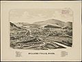
Lithograph of Miller's Falls from 1889 by L.R. Burleigh with list of landmarks
-
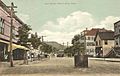
Main Street in 1910
-
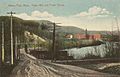
Millers River in 1912
-
Paper mill in 1912
.jpg)


See also
 In Spanish: Millers Falls (Massachusetts) para niños
