Erving, Massachusetts facts for kids
Quick facts for kids
Erving, Massachusetts
|
||
|---|---|---|
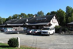
Freight House Antiques
|
||
|
||
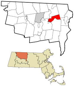
Location in Franklin County in Massachusetts
|
||
| Country | United States | |
| State | Massachusetts | |
| County | Franklin | |
| Settled | 1801 | |
| Incorporated | 1838 | |
| Government | ||
| • Type | Open town meeting | |
| Area | ||
| • Total | 14.4 sq mi (37.3 km2) | |
| • Land | 13.9 sq mi (35.9 km2) | |
| • Water | 0.5 sq mi (1.3 km2) | |
| Elevation | 515 ft (157 m) | |
| Population
(2020)
|
||
| • Total | 1,665 | |
| • Density | 115.6/sq mi (44.64/km2) | |
| Time zone | UTC−5 (Eastern) | |
| • Summer (DST) | UTC−4 (Eastern) | |
| ZIP Code |
01344
|
|
| Area code(s) | 413 | |
| FIPS code | 25-21780 | |
| GNIS feature ID | 0618163 | |
Erving is a small town in Franklin County, Massachusetts, United States. It's home to about 1,665 people, based on the 2020 census. Erving is part of the larger Springfield area.
Contents
History of Erving
Erving is located along the historic Mohawk Trail. Long ago, this area was home to the Pocomtuc Indian Nation. They had villages nearby, like Squawkeag and Peskeompscut. Over time, many native people were forced to leave their homes because of conflicts, including King Philip's War.
White settlers first came to Erving in 1801. The town officially became a town in 1838. It was one of the last areas in Massachusetts to become an official town. The town is named after John Erving, who was an early settler in the area.
In the 1800s, Erving was known for its forests and farms. There were many sawmills, which cut timber. People also made chairs, pails, and even children's carriages here. The forests provided lots of wood for railroad ties and telegraph poles. In one year, they cut almost 1.5 million poles!
Today, Erving has a school, a police department, and a fire department. It also has a public library, some small shops, and restaurants. The biggest employer in town is Erving Industries, a paper mill. This mill has a long history, connected to the "Paper City era" of Holyoke, Massachusetts.
Geography and Nature
Erving covers about 14.4 square miles (37.3 square kilometers). Most of this area is land, with a small part being water. The Millers River, which flows into the larger Connecticut River, runs through the town.
The land in Erving is quite hilly and rugged. Most of the town's buildings are located along the river. Northfield Mountain takes up a large part of the northern area. This mountain is home to a special power plant called a pumped storage hydroelectric facility. It stores energy by moving water between two reservoirs at different heights.
Route 2, a busy state highway, also passes through Erving.
Outdoor Fun in Erving
Erving is a great place for outdoor activities! The Erving State Forest offers places for recreation and camping during certain seasons. The Millers River is popular for fishing and whitewater kayaking, which is like rafting in a small boat.
Northfield Mountain has many trails for cross-country skiing and hiking. It's also a popular spot for rock climbing at a place called Farley Ledges. The long 114-mile (183 km) Metacomet-Monadnock Trail also goes through this area.
Population in Erving
| Historical population | ||
|---|---|---|
| Year | Pop. | ±% |
| 1850 | 449 | — |
| 1860 | 527 | +17.4% |
| 1870 | 579 | +9.9% |
| 1880 | 872 | +50.6% |
| 1890 | 972 | +11.5% |
| 1900 | 973 | +0.1% |
| 1910 | 1,148 | +18.0% |
| 1920 | 1,295 | +12.8% |
| 1930 | 1,263 | −2.5% |
| 1940 | 1,328 | +5.1% |
| 1950 | 1,322 | −0.5% |
| 1960 | 1,272 | −3.8% |
| 1970 | 1,260 | −0.9% |
| 1980 | 1,326 | +5.2% |
| 1990 | 1,372 | +3.5% |
| 2000 | 1,467 | +6.9% |
| 2010 | 1,800 | +22.7% |
| 2020 | 1,665 | −7.5% |
| 2022* | 1,667 | +0.1% |
| * = population estimate. Source: United States Census records and Population Estimates Program data. |
||
As of the year 2000, there were 1,467 people living in Erving. These people lived in 600 households. About 29% of these households had children under 18 living there.
The population includes people of all ages. In 2000, about 23% of the people were under 18 years old. About 14% were 65 years or older. The average age of people in Erving was 39 years old.
Education for Students
Erving has its own elementary school, called Erving Elementary School. After elementary school, students go to Great Falls Middle School. For high school, students attend Turner Falls High School in Montague.
See also
 In Spanish: Erving (Massachusetts) para niños
 | Sharif Bey |
 | Hale Woodruff |
 | Richmond Barthé |
 | Purvis Young |


