
Mohawk Trail facts for kids
Quick facts for kids |
|
|
Mohawk Trail
|
|

The Mohawk Trail, with Todd Mountain in the background
|
|

Location in Massachusetts

Location in the United States
|
|
| Nearest city | Greenfield and North Adams, Massachusetts |
|---|---|
| Area | 2,275 acres (921 ha) |
| NRHP reference No. | 73000283 |
| Added to NRHP | April 03, 1973 |
The Mohawk Trail is a famous road in northwestern Massachusetts. It follows an ancient path first used by Native American tribes. This historic route connected tribes near the Atlantic Ocean with others in Upstate New York. Today, it's known as one of the most beautiful drives in the state.
Contents
A Journey Through History
The Mohawk Trail began as an important trade route for Native American tribes. It helped them connect and trade goods across long distances. The trail followed rivers like the Millers River and Deerfield River. It also crossed the Hoosac Range mountains. This area is now northwestern Massachusetts.
Today, the Mohawk Trail is part of Routes 2 and 2A. It mostly follows the original Native American path. The modern trail stretches about 69 miles (111 km). It goes from Westminster, Massachusetts to Williamstown, Massachusetts. Along the way, it passes through many towns. These include Orange, Greenfield, and North Adams. You can see the beautiful Berkshire mountains from many spots.
Amazing Views and Fun Stops
The modern Mohawk Trail is famous for its stunning scenery. It is considered one of the most beautiful drives in Massachusetts. There are many interesting places to stop along the way. You will find scenic viewpoints and unique roadside attractions. There are also many gift shops.
One special stop is the Hail to the Sunrise statue at Mohawk Park. This statue honors Native American history and culture. Part of the trail runs next to the Deerfield River. It also passes through the village of Shelburne Falls. Here, you can see the unique Bridge of Flowers. The route crosses the Connecticut River on the historic French King Bridge. This bridge is 140 feet (43 meters) high!
The road reaches its highest point at Whitcomb Summit, at 2,272 feet (693 meters). On the western side, there's a popular hairpin turn and lookout. From here, you can see the city of North Adams and the Taconic Mountains. On the eastern side, the highway goes steeply downhill. It follows the Cold River to the Deerfield River. This section includes a famous curve called Dead Man's Curve.
Nature and Wildlife
A large part of the Mohawk Trail is surrounded by the Mohawk Trail State Forest. This forest covers about 6,400 acres (26 km²). It is a popular place for camping. You might even spot some wildlife here. Sometimes, people see bobcats and black bears.
The forest also has many old growth trees. These are very old and tall trees. Some of the tallest trees in Massachusetts are found here. Experts from the Eastern Native Tree Society have confirmed this.
The route also comes close to Vermont's southern border. You can take other roads north into Vermont. These lead to places like Harriman Reservoir. The western end of the trail in Williamstown connects to Mount Greylock. It also connects to U.S. Route 7 and New York State Route 2.
A Protected Historic Site
A section of the original Mohawk Trail footpath is very important. This part runs through Florida, Savoy, and Charlemont. It follows the Cold River valley. This historic section was added to the National Register of Historic Places on April 3, 1973. This means it is a specially protected area. Even though the original path is no longer fully visible, its historical importance is recognized.
Images for kids
-

Repair of Route 2 after a 6-mile washout along the Cold River caused by Hurricane Irene.
-
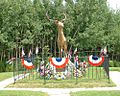
"The Elk On The Trail" statue, Whitcomb's Summit
-
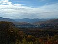
The Western Summit near the end of the Mohawk Trail, looking towards North Adams and the Taconic Range
-
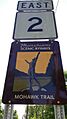
Massachusetts Route 2 at the beginning of the Mohawk Trail, Williamstown


