
Upstate New York facts for kids

Upstate New York is a large area in New York State that is north and northwest of the busy New York City area. It includes many different parts, like the Hudson Valley, the Capital District, the Mohawk Valley region, Central New York, the Southern Tier, the Finger Lakes region, Western New York, and the North Country. Some of the main cities you'll find in Upstate New York are Albany (which is the state capital), Utica, Binghamton, Syracuse, Rochester, and Buffalo.
Long before Europeans arrived, this land was home to several Native American tribes. The powerful Iroquois Confederacy, also known as the Six Nations, lived here. In 1609, Henry Hudson was the first European to explore the area. The Dutch then built Fort Orange (now Albany) in 1624, which was the first lasting European settlement in New York. Upstate New York saw many battles during the American Revolutionary War. After the war, the Iroquois tribes gave up most of their land to the new United States.
A big change happened in 1825 with the opening of the Erie Canal. This canal made it much easier to move goods from the Midwest and the Great Lakes through Upstate New York to New York City. Because of this, Upstate New York became a hub for factories during the Second Industrial Revolution. Famous companies like General Electric, IBM, Kodak, and Xerox started here. Many immigrants came to the region looking for factory jobs. However, since the mid-1900s, many factories have closed, leading to fewer jobs and people moving away. This area is now often considered part of the Rust Belt.
Upstate New York has a mix of landscapes, including cities, suburbs, forests, and farms. Its large rural areas mean farming is a big industry. The region is known for its dairy products, maple syrup, and fruits, especially apples. It's also a great place for winemaking. Important rivers like the Susquehanna, Delaware, and Hudson all start here. The Saint Lawrence River and the Great Lakes border its northern and western sides. This makes Upstate New York a key source of hydroelectric power (electricity from water) and drinking water for places like New York City. Many people visit Upstate New York for fun, enjoying places like Niagara Falls, the Adirondack and Catskill Mountains, the Thousand Islands, and the National Baseball Hall of Fame.
Contents
What is Upstate New York?


There isn't one exact line that separates Upstate New York from downstate New York. Some people think Upstate New York is everything except New York City and Long Island. This idea is common among people who live in New York City.
Other people draw the line further north, where New York City's suburbs end and smaller towns begin. This means that some parts of the Lower Hudson Valley, like most of Westchester and Rockland counties, are considered downstate. But the northern parts of these counties might be called upstate. Many people who live in the area use Interstate 84 as a way to tell the difference.
People who live in Upstate New York often identify more with smaller areas within it, such as the Hudson Valley, the Capital District, the Mohawk Valley, the North Country, Western New York, or Central New York.
History of Upstate New York
Early Times

Before Europeans came, the area was home to people who spoke Iroquoian languages, mostly west of the Hudson River, and people who spoke Algonquian languages, mostly east of the Hudson River. The Iroquois confederacy (Haudenosaunee), made up of five (later six) nations, was very powerful. Their land stretched from the Mohawk River Valley west through the state. They also controlled other large areas in the northeastern United States.
In the 1600s, the Dutch set up a colony called New Netherland in the Hudson Valley. They built Fort Orange (now Albany) in 1624. This area was important for the fur trade, which was very profitable. The French also set up trading posts further north. In 1664, England took over New Netherland and renamed it New York.
In the 1700s, the British became stronger in the region. William Johnson, a Scottish trader, lived among the Mohawk people, learned their language, and became their ally. The British also encouraged other Europeans, like German Palatines, to settle in the Mohawk Valley.
In 1754, leaders from seven British colonies met in Albany. They discussed a plan to unite the colonies, which was one of the first ideas for a united government. The region also saw many battles during the French and Indian War. By 1760, the British had taken over French lands in North America.
American Revolution and After

During the American Revolutionary War (1774-1783), colonists fought each other. The Iroquois were divided, with some supporting the British and some the Americans. In 1779, the American army, led by General George Washington, forced many Haudenosaunee from their homes.
Upstate New York was very important for both sides in the war. Key battles like the Battle of Saratoga (1777) happened here, which was a major turning point in the war. After the war, the Treaty of Paris set the border between New York and British Canada.
After the Revolution, New York State took land from people who had stayed loyal to the British. Many of these Loyalists and their Haudenosaunee allies moved to Canada. The United States recognized the Haudenosaunee's right to their remaining land. However, New York State officials later made deals to take more of this land. Today, three Iroquois reservations still exist in the region.
Many settlers came to Central and Western New York from New England. Land was given to Revolutionary War veterans in areas like the Central New York Military Tract.
The 1800s


Battles of the War of 1812 (1812-1815) were fought in Upstate New York, including the Battle of Plattsburgh. The city of Buffalo was even burned down by the British.
Slavery existed in New York for a long time. In the late 1700s, John Jay tried to end it. New York began to slowly end slavery in 1799. By July 4, 1827, the last 2,800 enslaved people in New York State were freed.
The Erie Canal was a huge project that started in 1817 and finished in 1825. It connected Albany to Buffalo, making it much easier and cheaper to transport goods. This helped Upstate New York become a major industrial area. Later, the New York Central Railroad also followed this route, helping cities grow even more.
In the years before the Civil War, Upstate New York became a center for people who wanted to end slavery. It was an important part of the Underground Railroad, a secret network that helped enslaved people escape to freedom. The women's rights movement also began here. The first women's rights convention was held in Seneca Falls in 1848.
The 1800s also saw many religious movements in Upstate New York. Because of this, the region was called the "Burned-Over District" by an evangelist named Charles Grandison Finney. Many new religious groups, like the Shakers and the Oneida Community, started here. The Mormons, Seventh-day Adventists, and Spiritualists are some groups that began here and still exist today.
By the 1870s, people realized that too many trees were being cut down in the Adirondacks, which could affect the water supply for the Erie Canal. This led to the creation of the Adirondack Park and Catskill Park, which are protected "forever wild" areas.
The 1900s and Today

After World War II, Upstate New York was very important to the national economy. Companies like IBM, General Electric, Kodak, and Xerox were very successful. The opening of the New York State Thruway in the 1950s made it easier to travel and transport goods. However, over time, many factories closed or moved, leading to fewer jobs and people leaving the area.
Despite these changes, there have been efforts to bring new businesses to the region. For example, GlobalFoundries, a company that makes computer chips, moved its main office to Malta, New York in 2021. Many Amish and Mennonite families have also moved to the area, helping farming grow again.
Upstate New York is known for its low crime rates, good schools, and affordable living. Cities like Syracuse, Rochester, Albany, Schenectady, and Buffalo have even been named great places to raise a family.
Geography of Upstate New York


Many important rivers, like the Delaware, Susquehanna, Mohawk, Hudson, and Allegheny, start in Upstate New York. The region has big mountains, large lakes, and huge forests.
The Catskill Mountains are in the southeastern part of the state, closer to New York City. The Adirondack Mountains are in Northern New York. These mountains are not part of the Appalachians but are an extension of the Canadian Shield.
The valleys of the Hudson River and Mohawk River have always been important routes for travel. Western New York, near Buffalo, is very flat because it was once the bottom of a glacial lake. The only "hills" in Niagara County are the Niagara Escarpment, which formed Niagara Falls.
Upstate New York shares a long border with the Canadian province of Ontario to the north and west, mostly along lakes and rivers. To the east, it borders Québec.
Upstate counties and towns are usually larger in size but have fewer people compared to those downstate. For example, Hamilton County has the fewest people, and St. Lawrence County is the largest in area. Both are in Upstate New York.
Climate

Upstate New York is famous for its cold and snowy winters, especially compared to the milder climate of downstate New York. Cities like Buffalo, Rochester, Oswego, and Syracuse get a lot of snow because of "lake-effect snow" from Lake Ontario and Lake Erie. Places in the Adirondacks, like Old Forge and Saranac Lake, are often some of the coldest spots in the country during winter nights.
Many of the natural features in Upstate New York, like the Finger Lakes, were formed by huge glaciers during the Ice Age.

Major Cities and Regions
Big Cities and Metro Areas
- Albany (the state capital) - Schenectady - Troy (this area is called the Capital District)
- Binghamton
- Buffalo - Cheektowaga (this is the largest city and metro area in Upstate New York)
- Rochester
- Syracuse (Central New York)
- Utica - Rome (Mohawk Valley)
-
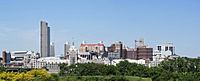
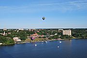
Albany
-
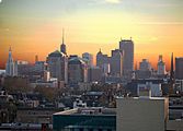
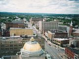
Binghamton
-
Buffalo
-
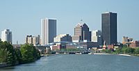
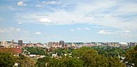
Rochester
-
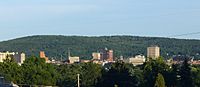
Poughkeepsie
-
Syracuse
-
Utica


Smaller Regions within Upstate New York

- Adirondack Mountains
- Capital District (the area around Albany)
- Catskill Mountains
- Central New York (the area around Syracuse)
- Finger Lakes (a region with long, narrow lakes)
- Hudson Valley (the middle and upper parts, not near New York City)
- Mohawk Valley (includes Utica and Schenectady)
- North Country (the very northern part of New York)
- Southern Tier (the area near the border with Pennsylvania)
- Western New York (the far western part, including Buffalo and Niagara Falls)
People and Culture

In 2020, New York State had over 20 million people. About 14 million lived in the New York City area, leaving about 6 million for the rest of the state, which is Upstate New York. If Upstate New York were its own state, it would be the 20th most populated state in the U.S.!
Upstate New York has a much lower population density than downstate. It has lots of farmland, forests, big lakes, and mountains, with cities spread out. Many people in Upstate New York have English, German, Irish, and Italian backgrounds.
The North Country has many people of French Canadian heritage. Italian Americans are the largest group in some counties, while Irish Americans are the largest in the Capital District, Syracuse, and Binghamton. Cities like Buffalo, Rochester, Syracuse, and Albany also have many African Americans.
The native Haudenosaunee (Six Nations) people also live in the region. They have special tribal lands, like the Seneca Nation in Western New York and the Onondaga nation south of Syracuse.
Local Foods and Festivals
Upstate New York has its own special foods:
- Buffalo wings and beef on weck sandwich (from Buffalo)
- Cornell chicken barbecue (from Ithaca)
- Garbage Plate (from Rochester)
- White hot dogs, called a white hot or Coney (from Rochester and Western New York)
- Salt potatoes (from Syracuse)
- Spiedies (from Binghamton)
- Chicken riggies, tomato pies, Utica greens, and halfmoon cookies (from Utica)
Winemaking is growing in the Finger Lakes. Welch's also has one of the oldest grape juice factories in the U.S. in this area.
Two very famous rock festivals happened in Upstate New York:
- The Woodstock Festival in 1969 in Bethel, New York.
- The Summer Jam in 1973 at the Watkins Glen International Raceway.
Economy of Upstate New York
The average household income in New York State was about $75,157 in 2021. Most counties in Upstate New York have incomes lower than this state average. The minimum wage in Upstate New York is $14.20 per hour, and it's planned to go up to $15.00 per hour.
Upstate New York has a strong mining industry. New York State is one of the top states for mineral production, and most of this comes from upstate. Central New York is a big salt-producing area. New York is also the only state that produces garnet (the state gemstone) and wollastonite. Logging is also important here.
Outdoor fun is a big part of the economy too. The Adirondack Park is visited by 7 to 12 million people every year, which is more than the Grand Canyon gets! New York State has the most ski resorts in the U.S. (52), and most of them are in Upstate New York.
Farming in Upstate New York
Upstate New York grows many farm products, including dairy, corn, hay, fruits, cabbage, and potatoes. It has a big dairy industry, and New York State is the largest producer of yogurt, cottage cheese, and sour cream in the U.S. Chobani, the biggest yogurt maker in the U.S., is located in Upstate New York.
The region also makes a lot of wine. New York State is the second-largest wine producer in the country, with most of it coming from the Finger Lakes area. New York is also the second-largest producer of apples, snap peas, maple syrup, and cabbage in the U.S., with the most production happening in upstate counties.
Factories and Technology
Upstate New York has a strong manufacturing sector. Many companies that make computer chips are here. This includes the main office and a factory for GlobalFoundries, one of the world's largest chip makers, in Malta. Other chip facilities are coming to Clay (Micron) and Marcy (Wolfspeed).
Upstate New York is also known for making glass. Corning Inc., a huge glassmaker that developed Gorilla Glass, is in Corning. In the past, Corning was even called "The Crystal City" because of its glass production. Tesla also has a factory, Gigafactory 2, in Buffalo.
Energy Production
Upstate New York produces more than half of the state's energy. Most of this electricity comes from nuclear power and renewable sources like hydroelectricity. In 2017, these sources made up 91% of the energy produced in the upstate region.
New York State is the third-highest producer of hydroelectric power in the U.S., and most of it is made upstate. The Robert Moses Niagara Hydroelectric Power Plant is one of the largest in the country. Upstate New York also has all of the state's nuclear energy plants, like the James A. FitzPatrick Nuclear Power Plant and the Nine Mile Nuclear Power Plant. Other important energy sources in the region include wind and natural gas.
Historic Events in Upstate New York
- The Albany Congress, 1754
- Battles of Saratoga, a turning point in the American Revolutionary War, 1777
- Sullivan Campaign, 1779
- The Erie Canal opens, 1825
- Publication of the Book of Mormon, 1830
- The Seneca Falls Convention, the first women's rights convention in the United States, 1848
- Jerry Rescue, 1851
- President William McKinley was assassinated in Buffalo, 1901
- Woodstock music festival, 1969
- Attica Prison riot, 1971
- Winter Olympics in Lake Placid, 1980
- Northeast blackout of 2003
- Continental Airlines Flight 3407 crash, 2009
- 2022 Buffalo shooting
Major Highways
- The New York State Thruway
- The Adirondack Northway
- Interstate 81
- Interstate 87
- Interstate 88
- Interstate 90
Major Universities and Colleges
Public Colleges (SUNY)
State University of New York (SUNY)
- University at Albany
- Binghamton University
- University at Buffalo
- SUNY Cortland
- SUNY Geneseo
- SUNY New Paltz
- SUNY Oneonta
- SUNY Oswego
- SUNY Plattsburgh
- SUNY Upstate Medical University
United States Military Academy at West Point
Private Colleges
- Alfred University
- Bard College
- Colgate University
- Cornell University
- Elmira College
- Hamilton College
- Ithaca College
- Marist College
- Niagara University
- Rensselaer Polytechnic Institute
- University of Rochester
- Rochester Institute of Technology
- Syracuse University
- Union College
- Vassar College
Fun Places to Visit


- Adirondack Mountains (great for hiking and nature)
- Baseball Hall of Fame (in Cooperstown)
- Catskill Mountains (another beautiful mountain range)
- Corning Museum of Glass (see amazing glass art and how it's made)
- Enchanted Forest Water Safari (a fun water park in Old Forge)
- Erie Canal (you can visit parts of this historic waterway)
- Finger Lakes (beautiful lakes for boating and exploring)
- Fort Niagara (a historic fort)
- Fort Stanwix (a reconstructed fort from the Revolutionary War)
- Howe Caverns (explore underground caves)
- Lake George (a popular lake for vacations)
- Lake Placid (host of the Winter Olympics twice)
- Letchworth State Park (known as the "Grand Canyon of the East")
- National Women's Hall of Fame (in Seneca Falls)
- Niagara Falls (a world-famous waterfall)
- Saratoga Race Course (famous horse racing track)
- Six Flags Darien Lake (a theme park)
- Six Flags Great Escape Resort (another theme park)
- Thousand Islands (a scenic area with many islands)
- Watkins Glen International Raceway (a famous race track)
Images for kids
-

Niagara Falls in the Niagara Falls National Heritage Area.
See also
 In Spanish: Upstate New York para niños
